Spring 2005
Spring 2005 |
|||||||
|
|
|||||||
City of El Paso, Texas, Implements an Enterprise GIS for Traffic and Pavement Management |
|||||
|
El Paso, Texas, and its sister city, Ju�rez, Mexico, constitute the largest metropolitan Maintaining existing roads and building new ones are challenges for any growing municipality. Without coordinated digital tools for planning, scheduling, and performing work, the city was documenting service requests and work orders with an antiquated DOS-based system. Status reporting was activity based and did not address asset-based accounting or inventory.
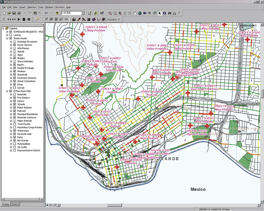
El Paso decided to meet these challenges by implementing a Traffic Management Information System (TMIS). The city began to search for a solution that would satisfy its requirements, which ranged from asset, service request, work order, and equipment management to pavement management. GIS functionality was seen as central to the system. Gerald Pucel, assistant street director, indicated that the key differentiator during the selection process was that the solution be GIS driven. The proposed enterprise solution placed the power of GIS at the system's core, giving the Street Department the ability to leverage the citywide GIS that was already in place while ensuring that any new GIS features developed by the Street Department would be accessible to all other city departments. The Esri team was selected by a citywide selection committee. The Esri Professional Services Division and Esri Business Partners Azteca Systems and TRANSMAP Corporation teamed up to develop and propose a comprehensive solution that would address the city's needs. System ImplementationTMIS was implemented in three phases. Phase I involved the deployment of an enterprise ArcSDE geodatabase, ArcEditor, and Azteca Cityworks asset and work order management software. Esri and El Paso configured the system and loaded the data necessary to provide Street Department personnel with the ability to create and manage service requests and work orders. The city was issuing service requests and work orders within three months. "The rapid deployment was well received by the user community during the first month," says Luis Vel�zquez, Street Department computer applications supervisor, "when more than 400 service requests and 1,500 work orders were created. Staff immediately realized the benefits of the GIS tools when locating service requests and work orders and planning daily maintenance activities." Phase II of the project involved collecting pavement and asset inventory information along 588 miles of existing roadway and 60 miles of new roadway. TRANSMAP Corporation, whose ON-SIGHT imaging technology was employed, led this phase of the project. Asset information was captured by a mapping van equipped with an inertial GPS and four positionally mounted digital cameras. The end product of Phase II was a highly accurate linear referencing system, a collection of road right-of-way assets, and pavement condition index ratings, all of which were stored in the ArcSDE geodatabase.
City staff had considered using traditional surveying techniques with GPS units to gather the information but found that it would be costly and time consuming. "The imaging approach eliminated the need to send Street Department staff into the field to collect this information manually," says Daryl Cole, street director. "The approach was safe, fast, and accurate and eliminated the thousands of potential man-hours that doing the work with city personnel and equipment would have required." Phase III built upon the previous two phases by adding enriched work order and pavement management functions and GIS data to TMIS. Esri implemented Micro PAVER, an application developed by the Construction Engineering Research Laboratory of the U.S. Army Corps of Engineers, and the Azteca Cityworks Micro PAVER interface on top of the existing enterprise ArcSDE geodatabase driven TMIS. System BenefitsThe primary focus of the Street Department is pavement management. Its most visible function is pothole patching, a task that is performed by as many as seven work crews throughout the city. Equipped with specialized trucks, these crews patch in excess of 200,000 square feet of city streets per year. One of the city's most cost-effective maintenance programs is the annual crack sealing activity. This program extends the life of paved surfaces by sealing the surface and preventing moisture infiltration to the base and subgrade. More than 270,000 linear feet of city streets are maintained yearly by two specialized crews using trailer-mounted crack sealers. The new integrated TMIS is capable of assessing pavement condition in such detail that each pothole and crack on the paved surface can be identified. It can also calculate an overall pavement condition index for the roadway section, implement the maintenance activities recommended by the pavement system, and map the pavement condition and work history in ArcEditor. "The geodatabase permits the seamless integration between these systems," says Cole. "This GIS-based approach has allowed Street Department managers to better plan and budget preventive pavement maintenance." The new TMIS replaces the previous system. Now all service requests and work order assignments are entered into the system in real time and immediately assigned to crews electronically. Status reporting is constantly being done, and updates are displayed on the map interface as they occur. Since September 2003, when TMIS started to work, the Street Department has processed more than 8,000 service requests and 28,000 maintenance and inspection work orders. The system has saved time by eliminating data entry duplication. It has also permitted better tracking of labor, equipment, and material usage costs, allowing the Street Department to justify the additional funding needed to maintain the city streets. One of the unexpected results of the project is that the Street Department now has access to more than 60 GB of digital images of every street surveyed during the project. These images are available for playback via an ArcEditor tool. The tool allows staff to go to any location in the city to perform a virtual drive down the streets in a matter of seconds and view digital images that represent a particular snapshot in time. Another unexpected result of the project is improvement in the accuracy of the city's street centerline basemap. This result benefits more than a dozen city departments that use this basemap. "The project leveraged the city's existing investment in GIS," says Robin Ransom, city of El Paso GIS manager, "and has resulted in a return on investment that can be seen many times over through the enhancements that have been made." TMIS has also improved customer service. The details of a citizen's request can be recorded, located, and assigned to a crew while the citizen is still on the phone. Call takers can access the history of each citizen's past calls to determine whether related problems have been reported in the past. The GIS also notifies the call taker of similar problems that have been reported recently in the vicinity. Future DirectionsThe Street Department has initiated another phase of the project with the Esri Professional Services Division. This phase, which began in March 2005, will include an additional pavement condition survey. The Street Department has developed a long-term partnership with Esri and its business partners Azteca Systems and TRANSMAP, helping bring the Street Department to the forefront of accountability, operational efficiency, and customer service. Says Cole, "We look forward to building upon the successes achieved with TMIS to help provide the public with better service and to provide safer streets for travel." For further information, contact Luis Vel�zquez, computer applications supervisor, city of El Paso (tel.: 915-621-6750; e-mail: VelazquezLA@elpasotexas.gov), or Eric Floss, Esri Professional Services (e-mail: efloss@esri.com; tel.: 678-417-1883, ext. 18). |
 area on the border of the United States and Mexico. Maintaining El Paso's vast network of roads and keeping up with the demand for new development are the primary responsibilities of the El Paso Street Department. The department has more than 300 employees and serves the citizens of El Paso through seven divisions: Street and Flood Control, International Bridge Toll Collections, Parking Meter Collection and Maintenance, Graffiti Removal, Sweeping, Traffic Signals and Signs, and Resurfacing Programs. The department maintains all city roads, alleys, ditches, ponding areas, medians, traffic control and school flasher devices, signs, crosswalks, and street striping.