Spring 2005
Spring 2005 |
|||||||
|
|
|||||||
Assessment and Coordination of a Complex Emergency
GIS Supports Indian Ocean Tsunami Disaster Relief |
|||||
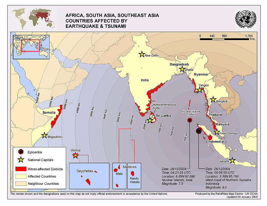
The devastating Indian Ocean earthquake and tsunami resulted in one of the world's most damaging and complex natural disasters in recent history. Estimates of nearly 300,000 casualties; 143,000 missing; nearly a dozen countries affected; and billions of dollars in international aid provide just a glimpse into the enormous impact of the terrible catastrophe. Entire cities and regions were destroyed, and landscapes and shorelines were changed forever. In the immediate aftermath, countless international organizations, relief organizations, and nations around the world responded, offering monetary donations, supplies, personnel, equipment, services, and much more. GIS played a pivotal role in the response activities for many of these organizations. The United Nations and U.S. government agencies that traditionally focus on international humanitarian emergencies were initially challenged to estimate the scope and extent of the disaster. From the beginning, GIS technology played a critical role in guiding emergency responders to affected areas and, once there, mapping the enormous impact of the event to coordinate the relief effort. The United Nations Office for the Coordination of Humanitarian Affairs (UNOCHA) was tasked with not only providing on-the-ground support and guidance for relief workers but also globally disseminating information on the event for the international community. UNOCHA established two Humanitarian Information Center (HIC) offices, one in Sri Lanka and the other in Sumatra. Each office made extensive use of GIS in the production of maps for humanitarian workers, such as maps of injured populations, damage assessments, and internally displaced persons. Among the most valuable products that HIC produces is the "Who Is Doing What Where" maps and database. These products are invaluable in communicating to relief workers which organizations are already addressing problems in a given area and where help is potentially still needed. More information on active Humanitarian Information Centers around the world can be obtained at humanitarianinfo.org. To promote the dissemination of information on global humanitarian events, UNOCHA maintains the ReliefWeb site (www.reliefweb.int). ReliefWeb is the world's most visited humanitarian information portal with more than one million hits a day. The ReliefWeb Map Centre is a repository of published maps on humanitarian events around the world. In addition to situation maps produced by UNOCHA, the Map Centre includes products from a diverse array of international sources. Another entity that has used GIS extensively in tsunami response activities is the United Nations Joint Logistics Center (UNJLC). UNJLC is an interagency facility whose mandate is to coordinate and optimize the logistics capabilities of humanitarian organizations during large-scale emergencies. UNJLC employed GIS to produce a detailed atlas of the damage to the transportation infrastructure of northern Sumatra; the atlas identified 178 damaged or destroyed bridges. With support from technical staff from the Vietnam Veterans of America Foundation, UNJLC used spatial analysis to determine that 41 of the identified bridges should be considered a priority in the redevelopment effort. Other United Nations agencies that used GIS technology in their response to the Indian Ocean tsunami disaster include the Food and Agriculture Organization of the United Nations, the United Nations Children's Fund (UNICEF), the United Nations High Commissioner for Refugees, the United Nations World Food Programme, UNOSAT, the World Health Organization (WHO), and others. U.S. government agencies played an enormous role in the response to the Indian Ocean tsunami disaster. The National Oceanic and Atmospheric Administration was one of the first to publish detailed animations of the tsunami that swept across the Indian Ocean. This and other products allowed responders to quickly realize the enormity of the event. In addition to deploying disaster assistance response teams to affected countries immediately following the event, the U.S. Agency for International Development (USAID) used GIS to produce maps of affected countries and related U.S. government programs in the area. The U.S. Department of State Humanitarian Information Unit, an interagency working group, used GIS to estimate the inundated areas of the tsunami as well as produce common operating picture maps that include economic impact, infrastructure damage, and U.S. government assistance. The U.S. Geological Survey disseminated a wide array of GIS products related to the tsunami via The National Map's Hazard's Data Distribution System. Many other U.S. government agencies played an active role in the tsunami response, including the Federal Emergency Management Agency and the U.S. Pacific Command's Joint Task Force/Civil-Military Operations Center. Unlike many previous international humanitarian emergencies, existing GIS infrastructure was able to rapidly meet the demands of the disaster response. One such example is the Pacific Disaster Center (PDC) whose existing GIS capacity was able to rapidly support the dissemination of valuable data, products, and imagery to the global response community. The PDC's mission is to provide research and analysis for the development of more effective disaster management and humanitarian assistance in the Asia Pacific region. In the wake of the tsunami disaster, PDC immediately embarked on several GIS-related activities, including the deployment of an ArcIMS software-based Map Viewer and its underlying service: the South East Asia and Indian Ocean Tsunami Response Map Viewer. The Map Viewer is designed to serve site visitors and GIS users and displays Landsat imagery, Shuttle Radar Topography, mission-derived shaded relief images, LANDSCAN-derived population density, detailed coastlines, damage polygons, and high-resolution imagery received from the U.S. government's Commercial Satellite Imagery Library. PDC also launched the Indian Ocean Tsunami Response Geospatial Information Service, an ArcIMS map service, supporting the GIS needs of emergency managers by providing direct access to data in the Map Viewer via ArcInfo software's ArcMap application, as well as convenient downloadable data to support field applications. This service is part of the PDC-hosted Asia Pacific Natural Hazards Information Network (apnhin.pdc.org). Although PDC has been a long-time user of ArcSDE, ArcIMS, ArcInfo, and other ArcGIS software, Esri sent technical staff to provide on-site assistance to help PDC ensure high availability of these critical information services in light of the extremely high traffic that they generated. Another example of existing GIS infrastructure that played a supporting role in the disaster response was the Geospatial One-Stop. A dedicated channel for the disaster was created on geodata.gov to catalog data sources, map products, and dynamic mapping services related to the tsunami. The geodata.gov Map Viewer allows users to integrate diverse ArcIMS and Web Map Server mapping services into a dynamic browser and produce maps that can be saved or shared with others. The architecture of the Geospatial One-Stop was well suited to information about nonspatial resources, as well as such volunteer organizations, local GIS firms, international organizations, and commercial companies that were interested in providing support.
As in countless pervious humanitarian emergencies, the nongovernmental organizations (NGOs) played an enormous role in responding to the tsunami disaster. One such NGO is MapAction, a United Kingdom-based international charity that specializes in applying GIS to mapping of disaster areas and supplying GIS products and information to support humanitarian relief operations. MapAction worked actively to map the damaged areas in Sri Lanka in support of the Sri Lankan government. Some of the valuable products that MapAction provided to the Sri Lankan government included maps of land mine hazards, damaged bridges, damaged schools, and camp locations of internally displaced persons. In support of its users around the globe, Esri and many of its international distributors quickly mobilized to provide support to international organizations, governments, and individuals responding to this complex emergency. One such distributor was Esri (Thailand) Co. Ltd. whose volunteers conducted damage assessments and assisted in the search for casualties (see sidebar on page 4). Using ArcGIS, the volunteers produced an atlas of the affected area—which included a one-kilometer reference grid—that allowed search and rescue personnel to effectively survey the damaged area. The survey team's observations were integrated into a daily situation map that was distributed to diverse organizations, such as the Rural Highway Department, the Telephone Organization of Thailand, local governments, and other volunteers. In addition, Esri (Thailand) employed video mapping technology, which coupled video shot from vans and helicopters with GPS data. Video mapping technology helped the response team rapidly estimate damaged areas over a large spatial extent. Another volunteer team from Esri (Thailand) assisted the Ministry of Natural Resources and Environment in the development of an ArcIMS service used to publish the geospatial data of the damage area in the southern part of Thailand. GIS data in the map service includes imagery, damaged areas, disaster operation centers, and recommended routes to affected areas and uses ArcData Thairoad as the basemap. The Web mapping application also provided an input mechanism for submitting information on the location of victims of the tsunami disaster. Many other Esri distributors in the affected areas contributed to the tsunami disaster response, including EMSO Limited (Sri Lanka), Esri Australia Pty. Ltd., Esri South Asia, and NIIT-GIS Ltd. (Esri India). Esri distributors who were not in the affected area, such as Esri Geoinformatik AG (Switzerland), Esri Italia, Esri Sweden, and Esri (UK) Ltd., became active in the response by supporting relief agencies in their regions. GIS professionals are increasingly making themselves available to support international development and humanitarian programs through volunteer organizations. The Urban and Regional Information Systems Association GISCorps was founded to coordinate short-term, volunteer-based GIS professional services for international programs. GISCorps (www.giscorps.org) was founded in 2003 as a not-for-profit volunteer organization aimed at matching interested and qualified GIS professionals with programs in need around the world. In response to the tsunami disaster, GISCorps provided volunteers and remote support to a variety of programs including Global MapAid, MapAction, Map Relief, Sustainable Environment and Ecological Development (India), and Vietnam Veterans of America Foundation. Within hours of the devastating Indian Ocean earthquake and tsunami, Esri began directly supporting many United Nations organizations, government agencies, and disaster responders with GIS software; mapping; GIS professional services; data collection, management, and dissemination; and industry expertise. "This was one of the largest disasters in history," says Russ Johnson, Esri's public safety industry manager, "and one of the immediate needs we recognized was the ability to identify what data was needed, where it was located, and which data needed to be built instantly. Getting the right data to the right people in the easiest, most efficient manner became a paramount concern. Mapping is important during the response and recovery stage of a disaster. It is critical in positioning facilities and services, determining a triage method to repair infrastructure, and determining loss in order to begin work on recovery. Esri and many of our business partners, including EarthSat, IBM, and Trimble, were ready to help with these efforts." Recovering from the tsunami disaster and returning the affected communities to their preevent condition will likely take decades. As the acute humanitarian risks are mediated, the long-term challenges of sustainable development, repatriation, relocation, and sanitation will need to be addressed. "Development activities will take place for months and years," says Johnson, "and GIS has a role to play here. Information will provide government officials and others with the support they need for addressing a myriad of concerns. The reconstruction, economic, and social factors involved all have a time and space component. GIS provides an invaluable framework for building an information base and providing the best decision support, communication, and collaboration possible." In addition to the long-term mitigation strategies, preplanning for future events is also underway. Discussions are taking place to evaluate and learn from current activities and to develop new processes and methods for rapid response for future emergencies of this scale. This involves identifying in detail how technology supported rescue, recovery, and rehabilitation; understanding where these implementations occurred; and describing how GIS technology can assist in preventing loss of life and property in future catastrophes. "There is a lot we can learn to be more prepared in the future," adds Johnson. Adversity can bring out the best in the human spirit as was demonstrated by the outpouring of support from around the world following the tsunami disaster. It should be duly noted that countless individuals and organizations put tremendous effort into responding to the disaster; clearly it was only possible to mention a fraction of them in this article. "GIS professionals really responded to the call and made a difference in the immediate, short-term, and long-term rescue and recovery efforts," says Jack Dangermond, president of Esri. "There were so many vital contributions; there's just not enough that can be said about the nations, agencies, volunteers, and others who helped when needed. In the aftermath of this disaster, organizations are looking at long-term spatial technology strategies that will aid in preevent planning and postevent rescue and recovery efforts for years to come." For more information, contact David Gadsden, Esri (e-mail: dgadsden@esri.com). |