Spring 2005
Spring 2005 |
|||||||
|
|
|||||||
Greensboro, North Carolina, Simplifies Access to City Services With GIS and a New One-Call System |
|||||
Situated in central North Carolina, Greensboro is the state's third largest city with a population of more than 220,000. Its economic roots date back to the early 1800s when it emerged as a textile manufacturing center. Today, this has given way to a mix of services, manufacturing, and product distribution. In a blend of old and new, the city skyline includes shimmering skyscrapers while the downtown district is listed on the National Register of Historic Places. An education center, Greensboro is home to two universities and three colleges, which add to its diversity and cultural activities. Greensboro's population and businesses steadily grew since its establishment in 1808 and so did the need for municipal services. The city is now a shining example of a culture dedicated to providing "excellence in service" to its citizens. Whether providing prompt answers to questions regarding the city library's operating hours or quickly repairing a broken streetlight, city employees believe in offering high-quality service. "This commitment has long been part of our culture and is the driving force behind everything we do," states Stephen Sherman, GIS manager for the city of Greensboro. Previously, Greensboro published more than 400 city service telephone numbers, and citizens did not know whom to call for help. "We wanted to make it easier for citizens to receive services from us," explains Sherman. The city began implementing a one-call center to receive citizen calls and ensure that inquiries are effectively addressed. Since many calls result in service requests, a new approach to city asset and work order management was required. "We needed to consolidate all work order and asset management into one system," explains Sherman. "We knew the location data in our GIS would tie the system together." In August 2003, Greensboro formed a committee and spent the next year planning, prototyping, and testing the implementation of a new enterprisewide asset management system that leveraged the city's GIS, its enterprise resource planning (ERP) systems, and the emerging Contact Center. Esri Business Partner Datastream (Greenville, South Carolina) was chosen as the asset management system provider after an elaborate evaluation process. "Tying Datastream to our enterprise GIS via Web services adds another dimension to this notion of creating a 'holistic' technology solution for how we manage our assets," states Sherman. Nearly a decade ago Greensboro began using ArcInfo to build an enterprisewide GIS system to serve as the foundation to improve the way services are delivered to citizens. The implementation began in August 2004 with the Greensboro Department of Transportation (GDOT). "We began with GDOT because its data is representative of other city departments," explains Sherman. GDOT has warehouse facilities that require materials handling and management; linear features, such as streets and pipes; and point features, such as street signs and signals. "Experience with these feature types will help us as we roll out the system across the city."
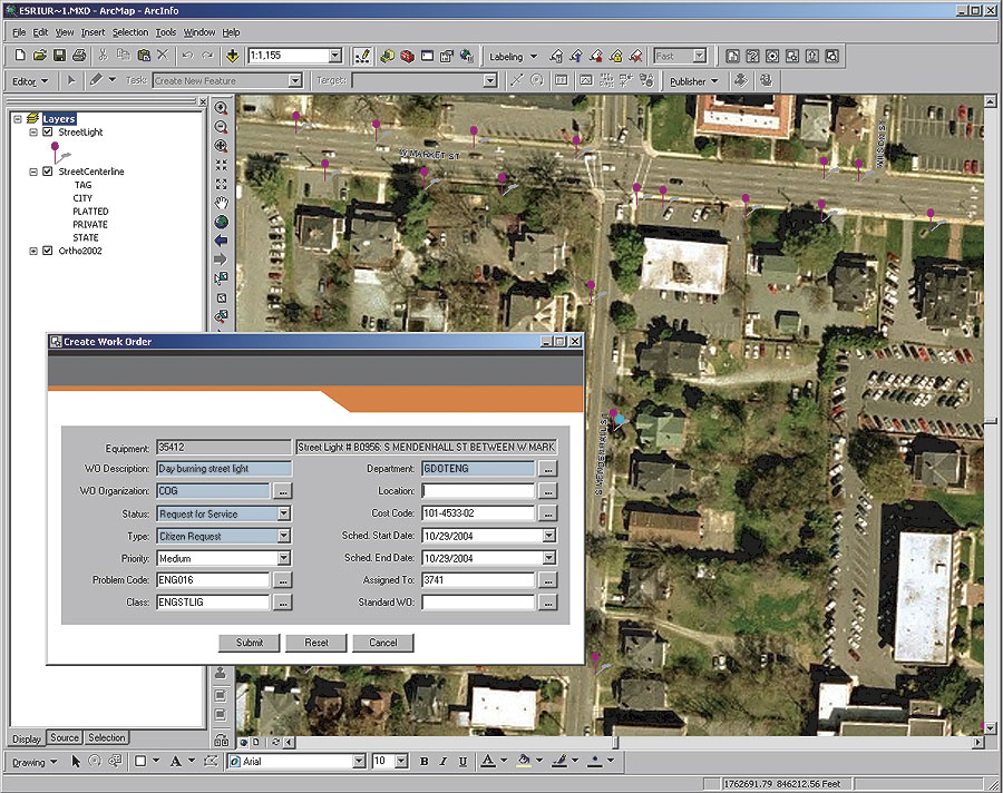
The city's Management Information System Department developed a customized application featuring an embedded ArcIMS map service, which accesses ArcSDE running on Microsoft's SQL Server. During GDOT's implementation, the city also built the connection to the ERP system and integrated the Contact Center with Datastream 7i, which, with ArcIMS, processes data in the background and is unknown to end users. This integration of assets, GIS, and the Contact Center provides city service representatives (CSRs) a customized browser-based view of all data needed to assist a caller. A work order begins when a citizen calls the Contact Center and is greeted by a CSR who listens to the concern—a pothole, for example. The CSR requests location information (street address or intersection) and geocodes and zooms the map display to the pothole's location. In this case, street centerlines automatically become the active layer. The CSR clicks the centerline containing the pothole to access the GIS record that is linked with a corresponding asset. The CSR adds comments, a problem code, and the citizen's name and phone number for follow-up. After the work order is created, it is automatically written to the asset management system using a Web services call. Sherman explains, "Previously, city personnel used paper maps to prepare work orders. Now, access to geodatabase data is embedded in their work order system." Next, the work order is automatically e-mailed to a supervisor's inbox, which shows new work orders and existing work in progress. The supervisor selects the new work order, views the map to identify the problem's location within GDOT's service districts, and assigns a crew. After the work is performed, paperwork is returned, hours and materials are recorded, and the job is closed. "Now we know turnaround time, as well as material, equipment, and labor costs to complete the job," says Sherman. "We also have detailed data of work performed on the street segment. Over time, a maintenance history is built. Using ArcInfo, we can identify and analyze streets with structural problems that previously could not be detected." Sherman explains, "By integrating ArcInfo with asset management tools, Greensboro also experiences faster turnaround time in performing work, particularly when it involves coordination between multiple departments. For example, a broken waterline requires Water Resources to dig up the street and fix the waterline. Next, GDOT fills the hole and patches the street. Finally, a different GDOT team repaints the street lines. Our system allows one team to complete its portion of a job and transfer the work order electronically to the next group and then on to the last. Previously, this repair required more time because it involved three different work orders and three different work order systems that were not tied together. Now we can efficiently repair the waterline and look at when the call was received, when the work order was completed, and what it really cost to fix the waterline." The city has leveraged additional value from its ArcSDE geodatabase. GDOT maintains an extensive inventory of the storm water system, representing more than 50,000 features that were collected for modeling but had not been used for maintenance. "The storm water system ArcSDE data was fed into Datastream 7i," adds Sherman, "giving immediate access to all assets needed to write work orders. We did not need to recollect 50,000 storm water features through a different process to load them into a work order system. The marriage of GIS and asset management is the core of what we've done with this project. This integration helped create feedback mechanisms. When assets change, such as construction of a new storm water curb inlet, we have a process by which completed fieldwork is fed back to the geodatabase, which keeps the GIS data current. The integration of these systems is truly complementary. "This application is a good example of how to embed ArcInfo into core IT technology," continues Sherman. "For asset management to work in a city, you must use GIS. You can't simply dig up a pipe to look at the serial number. The pipe's location is what makes it unique. ArcInfo and ArcIMS allow us to use location in conjunction with asset data so work orders can be written within the enterprise asset management system." For additional information on this project, contact Stephen Sherman, GIS manager, city of Greensboro (e-mail: stephen.sherman@greensboro-nc.gov), or Marty Osborn, Datastream (e-mail: marty.osborn@datastream.net), or Datastream (www.datastream.net). |