Spring 2005
Spring 2005 |
|||||||
|
|
|||||||
In Jefferson County, Kentucky, Voters Find Election Information on the Web With GIS |
|||||
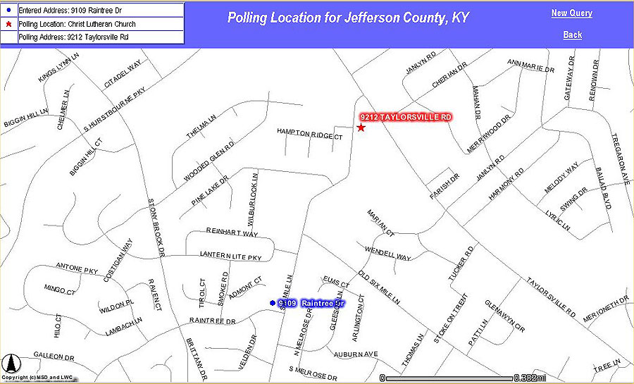
While the 2004 presidential race created more than the usual stress and scrutiny, it was not the only election the Jefferson County Board of Elections staff had to deal with. Local ballots for the 2004 elections included hotly contested races for U.S. Congress, state legislature, the local board of education, and several judicial seats. There were also 83 local suburban cities with races on the 2004 ballot. The board of elections wanted to develop alternative ways of getting more timely information out to voters using local data from the Louisville and Jefferson County Information Consortium (LOJIC) GIS. LOJIC is a partnership between the Louisville Metro Government, Louisville Water Company, Jefferson County Property Valuation Administrator, and Louisville/Jefferson County Metropolitan Sewer District. A longtime user of ArcInfo and ArcGIS, the board of elections maintains spatial databases of 506 local precincts, 143 political jurisdictions, and 271 polling locations in the community's shared LOJIC GIS. The wealth of other spatial data from LOJIC, including local site addresses and streets, combined with the capabilities of ArcIMS allowed the creation of a simple tool to provide voter information and site maps through the Internet. Voter Connection is available at www.lojic.org and provides interactive access to Jefferson County polling locations; site maps; and lists of local, state, and federal officials based on any local address. Voter Connection was enhanced for the 2004 election to include 279 jurisdiction-specific ballot styles to allow citizens to preview ballots and candidate names before going to the polls. The board of elections creates and maintains GIS data as Esri coverages (it has done so since 1992). Initially ArcInfo was used on UNIX workstations, which has evolved into the use of ArcView and, within the past year, the board of elections migrated to ArcGIS Desktop (ArcInfo). In addition, LOJIC staff has extensive programming experience in ArcInfo and ArcView and has created many complex and innovative applications used daily by its 350 users. This project was an excellent opportunity for the staff to start learning how to program in ArcIMS because it had a focused purpose and did not involve many data layers or complex queries. Because of the potential for high demand, a quicker option was also needed for citizens to be able to find the polling location for an entered address without viewing a map. Macromedia ColdFusion was selected to access the voter information database and provide a fast response.
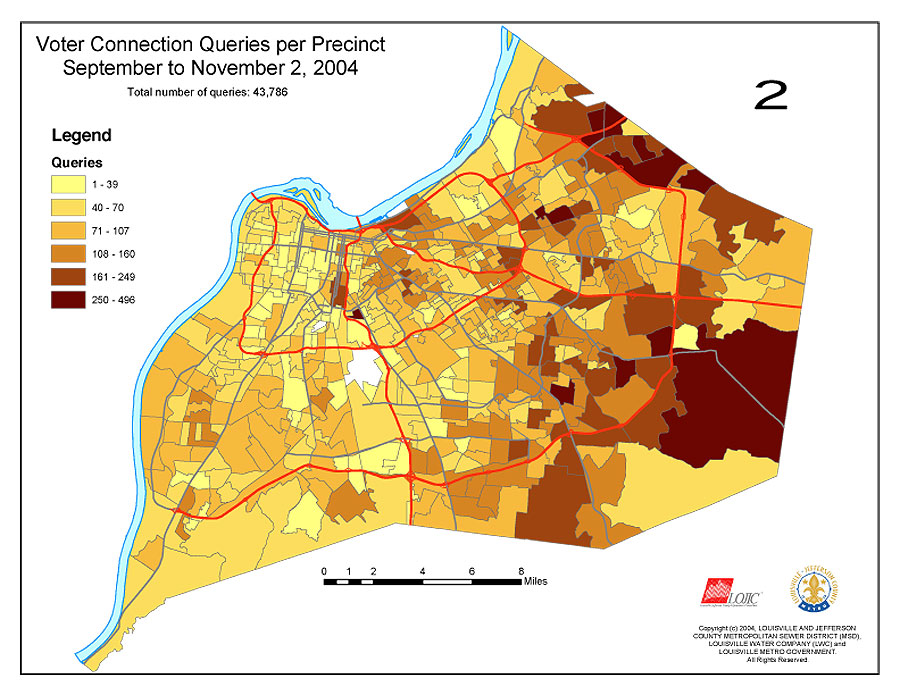
To build the voter information database, an ArcInfo ARC Macro Language (AML) program joined all the appropriate LOJIC GIS political data into one table based on precinct. This table relates to a street range database maintained by the board of elections that defines residential address ranges per precinct. An address is entered into the ColdFusion application that uses the street range database to find the correct precinct. This precinct is the key to finding the correct polling location and all the elected official information relating to that precinct. Citizens get basic voting information immediately, then have an option to view the information in a map. The precinct information is then passed to the ArcIMS application, which shows the entered address and the polling location on the street network. In 2004, sample ballots were also available for viewing. Because of the large number of suburban city races on the ballot, 279 unique ballots were used throughout the county. Precincts were again used to find the correct ballot for an entered address. Because these ballots look similar to the actual ballots used, many citizens found this addition extremely useful. Voter Connection had more than 43,000 successful queries from September through the November 2, 2004, election, and usage logs indicated that voters in every precinct accessed the tool. And in the end, local voter turnout was higher than usual as 71 percent of the nearly 500,000 registered voters in Jefferson County came to the polls. Links to Voter Connection appeared on the Web sites of every major media outlet, as well as the Web sites of the county clerk, Louisville Metro Government, the Kentucky Secretary of State, and several candidates. It was also heavily publicized on the local public affairs cable channel. Bill Lile, codirector of the Jefferson County Board of Elections, says, "The main benefit has been the reduction of incoming phone calls for polling site information. We hope to see eventual relaxation of the requirement for printed advertising of the ballot, which cost $64,000 in the 2004 general election. This would require passage of legislation by the General Assembly of Kentucky." For more information about Voter Connection, contact Shawn Merrick, information systems manager, Jefferson County Board of Elections (e-mail: smerrick@mail.jc.state.ky.us, tel.: 502-574-6113); Lisa Kraft, mapping and statistical coordinator, Jefferson County Board of Elections (e-mail: lkraft@mail.jc.state.ky.us, tel.: 502-574-8284); or Jane Poole, GIS products specialist, LOJIC (e-mail: poole@lojic.org, tel.: 502-540-6435). Voter Connection can be found at www.lojic.org/apps/voter/index.cfm. |