Spring 2005
Spring 2005 |
|||||||
|
|
|||||||
Dr. Birut� Mary Galdikas—Working in the Jungles of Borneo for More Than 33 Years
The Orangutans of Borneo Are Aided With GIS |
|||||||
There are so many words that can describe Borneo, including verdant, vast, and vibrant. It is the world's third largest island with an extremely diverse flora and fauna that include more than 380 species of birds, 222 species of mammals, more than 2,000 species of orchids, and more than 3,000 species of trees. Borneo is one of 17,000 islands that comprise the country of Indonesia, and it's one of two places on the planet where orangutans live. Unfortunately, as in the case with many other tropical paradises, Borneo's forests are rapidly disappearing and the orangutans with it. More than 80 percent of Borneo's forests have already been logged. Over the last 20 years, the amount of wood exports from Indonesian Borneo has surpassed all tropical wood exports from tropical Latin America and Africa combined. Borneo also lost at least 39 percent of its orangutan habitat from 1992-2002. If the rate of destruction continues at its current clip, the rain forests and its orangutan residents could vanish by 2015. Dr. Birut� Mary Galdikas has worked in the jungles of Borneo for more than 33 years. She is one of three women that Dr. Louis Leakey recruited to work on the great apes; this is an illustrious group that also includes Dr. Jane Goodall (see Dr. Jane Goodall to Present Keynote Address at Esri User Conference) and the late Dr. Dian Fossey. With the increasing effects of illegal activities and the fires of 1997-1998, Dr. Galdikas and her team at Orangutan Foundation International (OFI) have had to redouble their efforts to save the site where she has done her life work: Tanjung Puting National Park (TPNP). TPNP covers roughly 4,000 square kilometers and is one of the largest protected areas of tropical heath and peat swamp forest in Southeast Asia. It also contains the largest population of orangutans in a protected area, approximately 6,000. Working in conjunction with World Education Inc., OFI received funding from the United States Agency for International Development (USAID) in October 2003 for a program that aims to apply an integrated conservation and development approach to the protection of TPNP and its resident orangutans. The project's objectives are fourfold:
ArcView software plays a significant role in this project and is now being used to support stakeholder decision making while improving biological analyses and monitoring. Going forward, GIS will support the integration of land use planning with local economic and conservation needs and assist in the effort to develop a more thorough understanding of the orangutan population of TPNP. GIS activities are already providing the first comprehensive, large-scale mapping and analysis of orangutan habitats in TPNP. Critical areas for conservation and management are being identified, and GIS data under development now will support long-term management of the park's valuable resources. In October 2003, OFI began a comprehensive GIS program as part of its USAID work. Data layers of physical and political features were created from existing GPS, GIS, and hard-copy data from a variety of sources. Satellite imagery was used to generate a land cover map of the area, which will provide the key element of orangutan habitat mapping and conservation planning.
The primary challenge in using optical remotely sensed imagery to detect land cover in tropical regions, such as Borneo, is prevalent cloud cover that obscures ground conditions. Therefore, it was necessary to examine a number of Landsat scenes using a Web GIS application, the United States Geological Survey Global Visualization Viewer (glovis.usgs.gov), to preview the imagery and discern whether cloud-free images could be obtained. The GIS team obtained the most recent image, an ETM+ scene from April 2003, from the Tropical Rainforest Information Center at Michigan State University. 1999 and 2001 Landsat TM scenes were obtained through nonprofit partners. The GIS team determined the 2001 and 2003 scenes to be the most useful. It used ERDAS IMAGINE to composite the 2001 and 2003 images and classify land cover using unsupervised classification. In November 2004, OFI began recruiting volunteers to assist with satellite imagery ground-truthing fieldwork, which was conducted for one month in June 2004. The results of this fieldwork were used to identify ground conditions for all land cover classes in diverse settings throughout the park. The volunteers recorded data for vegetation type, canopy height, canopy closure, water level, and disturbance. This data was then used to conduct a supervised classification and refine the land cover map.
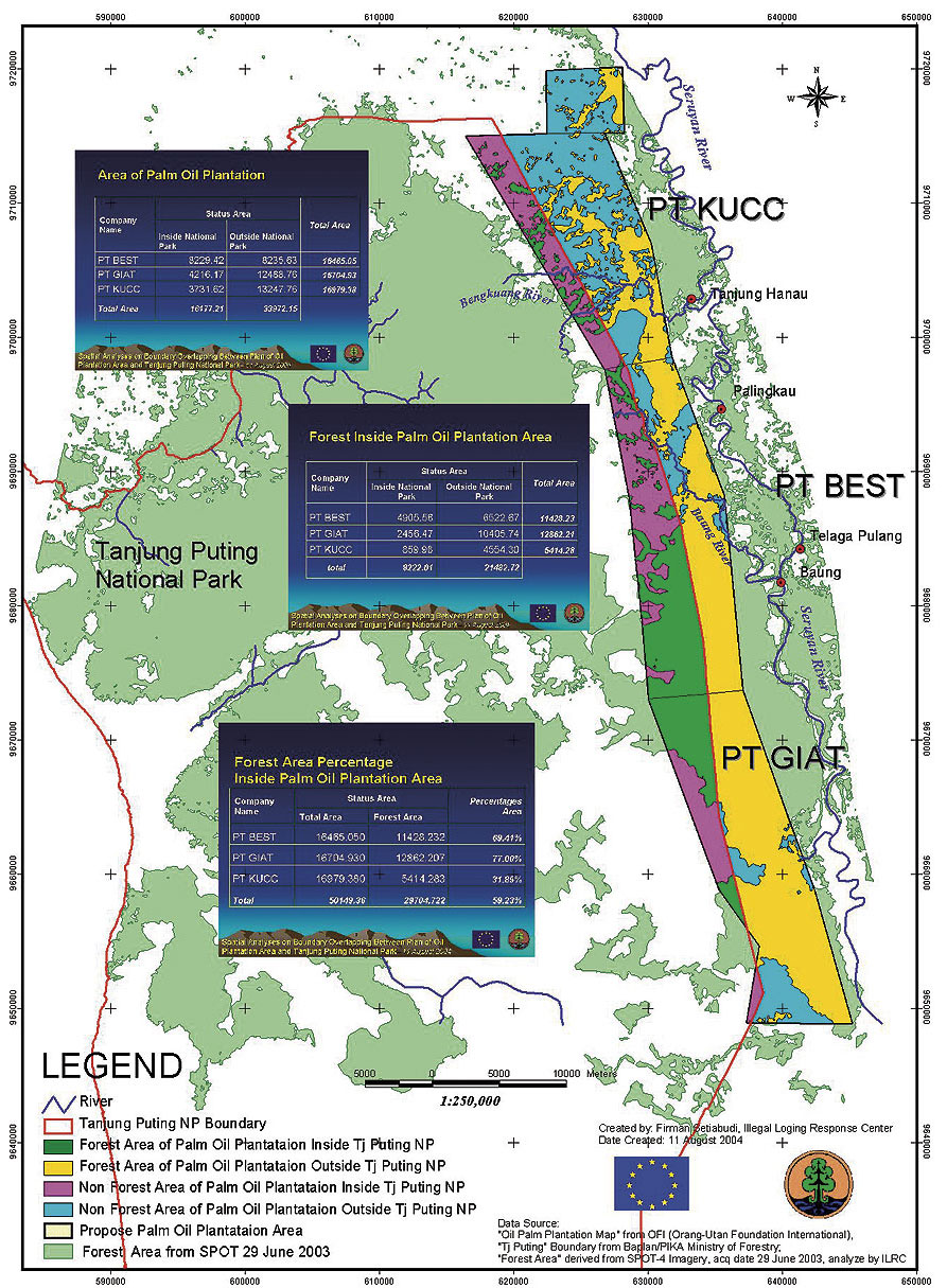
The volunteers also collected detailed data in agricultural areas, including large-scale rice plantations in the western part of TPNP and an extensive palm oil plantation along the northern border of the park. They visited logging canals still operating in the eastern part of the park so these critical areas could be mapped and more effectively monitored. The volunteers, all with prior experience using GIS and GPS technologies, convened in May 2004 for two days of intensive training and again in June at Camp Leakey for another day of training. Each field team used a GPS unit to map land cover point and line features that were later compared to the spectral signature of the satellite imagery. Tropical field conditions were rough; everyone slogged through knee- to waist-deep swamps daily. Once the data was collected from the field, it was merged into thematic files using Trimble PathFinder software, edited by each field team in ArcView software, and uploaded to the data server as shapefiles. Vector data needed by the program was acquired from the Global Forest Watch Web site (www.globalforestwatch.org). The other major source of data was Conservation International (www.conservation.org). The GIS team displayed, queried, edited, and analyzed all the vector data initially using ArcView software in the OFI team headquarters in San Diego, California, and then in the OFI office in Borneo. During the data analysis process, the GIS team discovered the survey line of a proposed palm oil plantation that encroached three miles into the existing park boundary. Based on the GIS analysis, OFI investigated and discovered that the plantation owner had scheduled forest clearing to begin July 1, 2004. OFI staff immediately contacted the Indonesian Ministry of Forestry to protest this illegal encroachment into the park. There was also an outcry from the local community that didn't want to see the neighboring lush forest turned into rows of palm oil trees, which would destroy their rice fields, river water quality, and fishing. The Indonesian Ministry of Forestry required the plantation owners to stop their plans to bulldoze the forest inside the park boundary. Unfortunately, the boundary controversy has not been permanently settled, since the Indonesian Ministry of Forestry has now designated the long-established park boundary as "temporary." The ArcView GIS Intersect geoprocessing tool was used to calculate the areas and quality of habitat remaining inside the area proposed for palm oil conversion. Using this information, OFI is now working with its partners, including the Illegal Logging Response Centre, to secure permanent status for the current park boundary. GIS will continue to play an important role in assessing habitat conditions in TPNP. As part of ongoing data collection, OFI is currently mapping the villages inside the park. These village maps will be used to help resolve border issues and prioritize management for the park. To support growing GIS activities, GIS training was conducted (see The Field Staff of the Orangutan Foundation International Trained in GIS) for the OFI local staff in November 2004 in Borneo. With the recent availability of ArcInfo 9 licenses, more advanced data editing, image registration, and GIS analysis capabilities will be used to calculate the areas and quality of orangutan habitat remaining inside the park. GIS will also provide a spatial context for regional analysis of habitat conservation, helping planners and decision makers protect the park and identify surrounding areas in need of conservation. This work will help preserve TPNP as prime orangutan habitat for many years to come. For more information, contact Leslie Smith, GIS project manager (e-mail: labsmith@ucdavis.edu, Web: www.orangutan.org) or Dr. Birut� Mary Galdikas (e-mail: ofi@orangutan.org). |

 Land cover at TPNP is dominated by peat swamp and upland heath forest types in a mosaic of secondary forest and ruderal vegetation. For the initial land cover map, the focus was on delineating broad vegetation and land cover classes. Given the size of the study area and the level of detail needed, the GIS team determined that Landsat imagery satisfied the spatial and spectral resolution required to conduct land cover classification. Landsat Thematic Mapper (TM) and Enhanced Thematic Mapper Plus (ETM+) scenes cover approximately 31,000 square kilometers in Borneo, and all of TPNP was included in one image. Landsat sensors TM and ETM+ provided 30-meter spatial resolution and seven spectral bands, which enabled the differentiation of 40 image classes. The GIS team recoded them into 14 major habitat types using ERDAS IMAGINE classification tools.