Spring 2006
Spring 2006 |
|||||||
|
|
|||||||
New Orleans, Louisiana, Leverages Spatial Data to Aid in Damage Assessment Efforts After Hurricane Katrina |
|||||
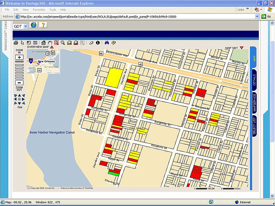
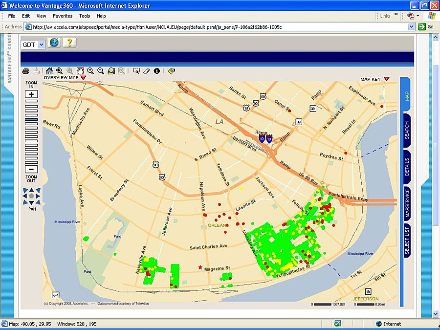
Located in southeastern Louisiana along the Mississippi River, the greater metropolitan New Orleans area extends about 360 square miles (200 land, 160 water) through the parishes of Orleans, Jefferson, St. Bernard, and St. Tammany. In September 2005, Hurricane Katrina devastated most of New Orleans and the surrounding Gulf Coast communities. Once survivors were rescued and floodwaters were drained, one of the city's most important tasks involved damage assessment of the city's commercial and residential buildings. Of the city's 180,000 structures, 125,000 were flooded and half of those sat for days or weeks in more than six feet of water. Inspecting these buildings was going to be an enormous task, but the city was well prepared. Automating the Business of GovernmentIn 2003, following a period of evaluation, the city's Department of Safety and Permits implemented a Web-based land management solution to automate key department activities, including permitting, inspections, and application review. The application, which was developed by Esri Business Partner Accela, Inc., tied ArcIMS to the city's land permitting and management system, automating the map analysis and streamlining the daily activities of the department. While using the land management application on a daily basis immediately following the hurricane, city officials realized the technology could be leveraged to expedite damage assessment. Working in close partnership with technology partners Tele Atlas/TomTom and Panasonic, the Accela team configured and preloaded 25 Toughbook laptops, donated by Panasonic, with mobile inspection management software and important geographic data gained from ArcIMS that would be needed to complete inspections. Anticipating a lack of wireless connectivity in the field, the mobile units had to be configured with as much information and resources as possible so inspectors would be able to effectively do their jobs. Esri Business Partner Tele Atlas/TomTom provided complete street network and parcel data to augment the city's existing GIS database. Mapping the DamageCity inspectors were dispatched to the field to perform inspections in New Orleans and the surrounding parishes. Inspectors were able to identify buildings in various ways�using verified addresses from the city's GIS database, using built-in GPS capabilities in the laptops to assign x,y coordinates to the inspection site, or by entering a physical description of the area. The flexibility of these geolocation tools was important because, following the hurricane, many street landmarks were moved, destroyed, or missing. In addition, inspectors were confident that the data they were collecting was based on validated address information, ensuring accurate results.
Because the system was built on the ArcIMS platform, it was able to support bidirectional communication between the field applications and existing GIS datasets, such as parcels, addresses, street centerlines, etc. The Accela system also facilitated inspectors performing their house-to-house recovery jobs. Once the structures were inspected, they were assigned a color-coding based on the extent of the damage (red, yellow, green). The system then mapped this information automatically to a GIS map layer, highlighting individual parcels as red, yellow, or green. This feature is especially valuable for city officials who want to see a big picture view of the most heavily damaged areas. Automating the damage assessment process expedited the department's work tremendously. According to Mike Centineo, director of the Department of Safety and Permits, "Doing this huge task with written reports would have been a nightmare. Putting the data into a database after the fact is cumbersome and can be inaccurate. We were able to conduct the inspection; upload the data for instant reporting, viewing, and GIS integration; and have a visual picture of where we stood instantly." Using a mobile inspection management solution, the department was able to process more than 3,000 inspections per day. The city completed all of its initial inspections—more than 125,000 structures—in less than three months. Continues Centineo, "I can truly say that without the help of this technology, we would be doing these inspections by paper and pencil and then would have the huge task of converting all this data into a database suitable for reporting needs. I cannot imagine how long that would take; this was blessed help in our darkest hour." Looking AheadThe city has published this information on its Web site so residents can look up inspection results for their property address. Depending on the extent of the damage, residents will have the option to repair or demolish their homes. To expedite this process, the city is providing online access to permit processing. Visitors to City Hall can access one of eight available kiosks to get online and view damage assessment reports, find information about next steps, and immediately apply for the necessary permits. City officials anticipate that of the 125,000 buildings inspected, approximately 92,000 will need some type of permit. As the city continues its cleanup and rebuilding efforts, the Department of Safety and Permits feels confident that it will be able to continue providing efficient and effective services to the citizens of New Orleans. More InformationFor more information, contact Mike Centineo, director of New Orleans Department of Safety and Permits (e-mail: MCentineo@cityofno.com), or contact Accela, Inc. (e-mail: info@accela.com, Web: www.accela.com/katrina). |