Spring 2006
Spring 2006 |
|||||||
|
|
|||||||
The Province of Qu�bec, Canada, Manages Stream Crossings and Forest Roads with GIS |
|||||
|
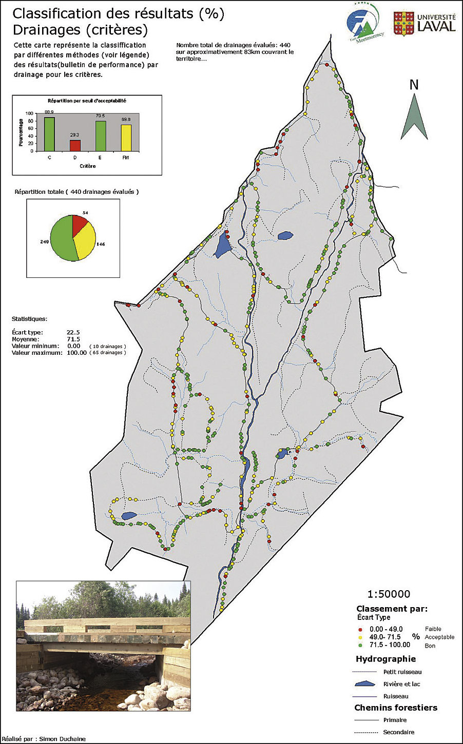
By Dominic Toupin and Hugues Sansregret, Universit� Laval, Qu�bec, Canada
How do landscape managers deal with wildlife habitats, road construction or maintenance, and stream crossing degradation with a planning and economic perspective? The province of Québec, Canada, is well known for its natural water network and downstream (watershed). With more than 4,500 stream crossings in the Montmorency downstream (1,150 km2 or 284,170 acres), information about stream crossing location, quality, and management is critical. In 1964, the government of the province of Qu�bec turned over management of 66 km2 (16,500 acres) of territory to Universit� Laval. In return, the university undertook to manage it using the best known forest management methods in accordance with the principles of multiple-use management. The For�t Montmorency (FM) is located in the Montmorency downstream approximately 70 km (42 miles) north of Qu�bec City. Universit� Laval needed historical data for stream crossings and roads to help in the management and planning of repairs and maintenance of those structures. Consequently, the FM Traverse 2005 project was developed to acquire the data and provide the analysis required for forest stream crossing and wildlife habitat management. One of the FM Traverse 2005 objectives was to develop a spatial database to store and analyze data collected in the field. This spatial database is part of the environmental management system used in a water quality continuous improvement initiative. Universit� Laval has been using ArcGIS Desktop (ArcInfo) for both educational and research purposes. ArcGIS is the instructional application utilized by the students of the Facult� de Foresterie et de G�omatique, and For�t Montmorency also uses ArcInfo for its fieldwork and development. The board of directors of For�t Montmorency and researchers first identified a list of environmental objectives to pursue based on provincial government regulations. Then, a geodatabase was created with the necessary attributes for data collection. A user-friendly data entry form needed to be programmed so it could be used by forestry technicians. The geodatabase model was the best spatial data management model to accomplish this goal. A Getac mobile computer with an integrated Garmin GPS receiver was used to capture the x,y locations of stream crossings and store scoring of the environmental objectives for each.
A Visual Basic for Applications-coded interface with data entry forms was developed in Microsoft Access to add the x,y location data directly into the geodatabase. Thematic maps with data classification were then produced with the ArcGIS application ArcMap to give the For�t Montmorency board of directors a global view of the stream crossing installations and their degradation caused by both weather and use of the roads. These maps helped manage and plan stream crossing repairs and maintenance. A color system (green=good, yellow=objectives/problems, red=crossing repairs needed) was used to illustrate stream crossings. Thus, these maps gave For�t Montmorency managers a support system tool. A survey of the territory within the compass of FM Traverse 2005 combined with ArcGIS has already shown an improvement in the For�t Montmorency management system. GIS helps visualize the environmental objective score for the 440 roadbed drainages and more than 60 culvert and crossing installations. The FM Traverse 2005 project has proved useful for assessing economic priorities in accordance with environmental objectives. So far, this system gives the opportunity to maintain a continuous survey of the historical archives for forestry management operations and road construction. For more information, contact Hugues Sansregret, director, For�t Montmorency, Universit� Laval, Qu�bec (e-mail: hugues.sansregret@ffg.ulaval.ca, tel.: 418-846-2046, Web: www.fm.ulaval.ca). |