Spring 2006
Spring 2006 |
|||||||
|
|
|||||||
Federal Geographic Data Committee Cooperative Agreement Program
Westchester County Awarded Grant to Boost Local Government GIS Programs |
|||
|
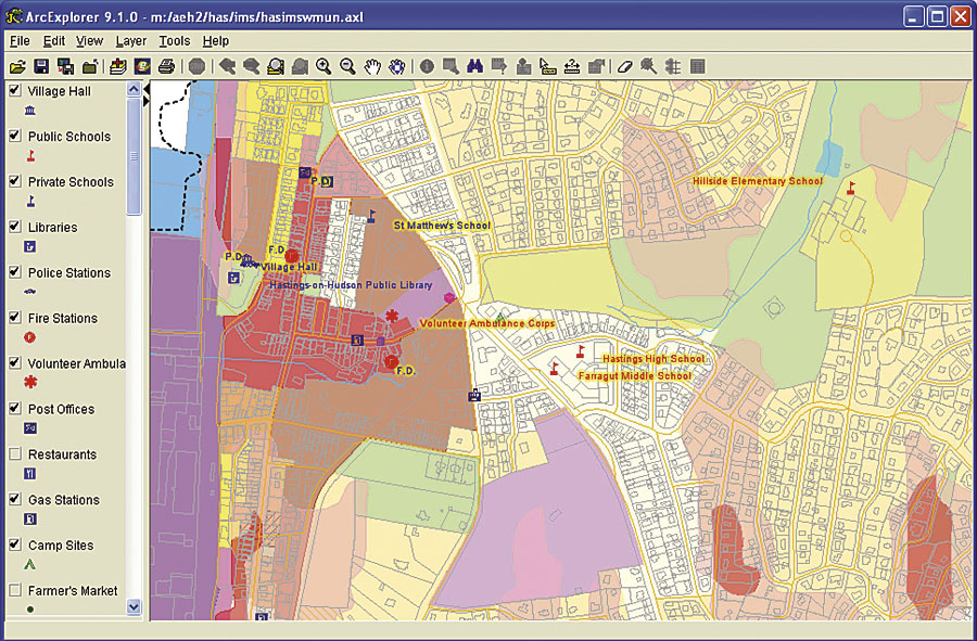
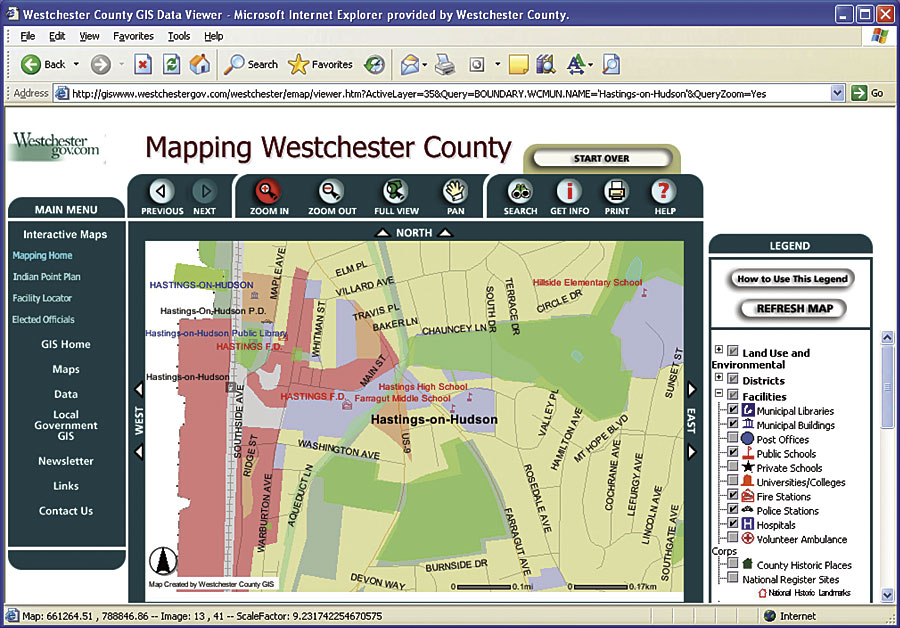
Westchester County, New York, located just north of New York City, recently received a U.S. grant to expand its GIS and Web mapping programs with local governments. The county is one of 36 public agencies or national organizations to receive the grant in 2005 and will leverage its existing GIS and Web mapping architecture to build individualized Web mapping capabilities with three municipal partners, the city of Mount Vernon, town of Mamaroneck, and village of Hastings-on-Hudson. A central component of the project will be registering the local government Web mapping services with the Geospatial One-Stop (GOS) program.
"The grant gives us the opportunity to help build applications for local government," says Sam Wear, GIS manager in the county's Department of Information Technology. "We want to showcase the efficiencies of leveraging a built county GIS environment to assist local governments in creating Web services for their needs." The grant is administered by FGDC, which is developing the National Spatial Data Infrastructure (NSDI). As an extension of NSDI's relationship to FGDC, GOS was created to improve the ability of the public and government to use geospatial information to support the business of government and facilitate decision making. GOS provides an innovative way to share geographic information. The portal "harvests" metadata from local sources, such as Westchester County, and makes the information available at the GOS Web site. Utilizing search and query functions available at the GOS site, users can search and view Westchester County GIS metadata, download county GIS data, or view online mapping applications. The GOS application also enables users to interactively access and integrate data from other ArcIMS Web mapping services. Wear compares the way GOS is set up to the concept that made the music-sharing portal Napster such a success, saying, "Data generators and data consumers are increasingly using search tools that are powerful and easy to use and gain access to geospatial datasets with a minimum amount of administrative overhead. The GOS Web portal is a lighter and evolving means of searching for and accessing geospatial data. Extending the capability for smaller governments to make spatial data and Web mapping services' metadata available through the GOS portal is very significant." The multigovernment collaborative project includes preparing a generic Web mapping portal that can be customized for each municipality. Users will be able to view/identify and perform general ad hoc queries, add/remove layers, geocode single address locations, and create letter-size maps depicting a wide range of environmental, demographic, planimetric, cultural, and facility data using a predefined map template. Access to each of the portals will be through individual Web sites. The grant will also support integration of new datasets, such as tax parcels, that are being developed and managed at the local level. Metadata training is being provided to local government officials so FGDC-compliant metadata can be developed for registering local data sources and mapping services with GOS.
Angie Witkowski, director of Planning, village of Hastings-on-Hudson, comments, "The GIS applications have been a great asset�particularly for the tax office and the police, planning, and building departments." Westchester County GIS has been developing its spatial data repository since 1986 and has a history of participating in similar collaborative activities, including preparing GIS needs assessments, leading development of a large-scale countywide basemap, and proactively sharing spatial data in government and industry. Its current enterprise GIS system is based on ArcGIS Desktop architecture running with Oracle and supports applications ranging from environmental planning and transportation to engineering and public works. "By taking all the county information with any type of location information in it, making it viewable through an enterprise GIS, and extending this capability to municipalities, we are able to share a common language and ability to coordinate," says Dr. Norman J. Jacknis, chief information officer, Westchester County. Westchester is also the first county in the United States to contribute and publish metadata through GOS. County staff developed a customized application that allows GOS search engines to pick up the county's metadata records on a regular basis and used the ArcGIS Desktop application ArcCatalog to create and publish metadata to the application. Software components required to develop the application included ArcGIS Desktop, ArcIMS, ArcSDE, and the Oracle relational database. In 2004, Westchester County began updating the countywide digital basemap, including planimetric and street feature datasets. The update is augmented by the production of new high-resolution, color orthophotography and new two-foot contour data. A separate state grant for $22,500, awarded in 2006 by the New York State Department of Environmental Conservation's Hudson River Estuary Grant Program, will allow the Department of Information Technology to create an inventory of vacant Hudson River frontage properties. That data will be integrated into the online mapping program and be used to further open space planning initiatives at the regional, county, and municipal levels. For more information, visit the Westchester County GIS Web site (giswww.westchestergov.com) or contact Sam Wear (e-mail: stw1@westchestergov.com). For more information on the Federal Geographic Data Committee, visit its Web site (www.fgdc.gov) and the Geospatial One-Stop portal (www.geodata.gov). |