Spring 2007
Spring 2007 |
|||||||
|
|
|||||||
New Features Added—Enhanced Performance and Functionality Assist Users with Critical Decisions
ArcGIS Business Analyst 9.2 Now Shipping |
|||||
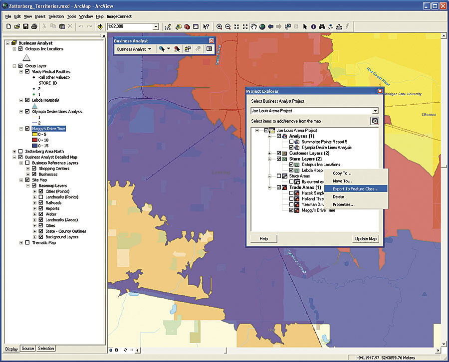
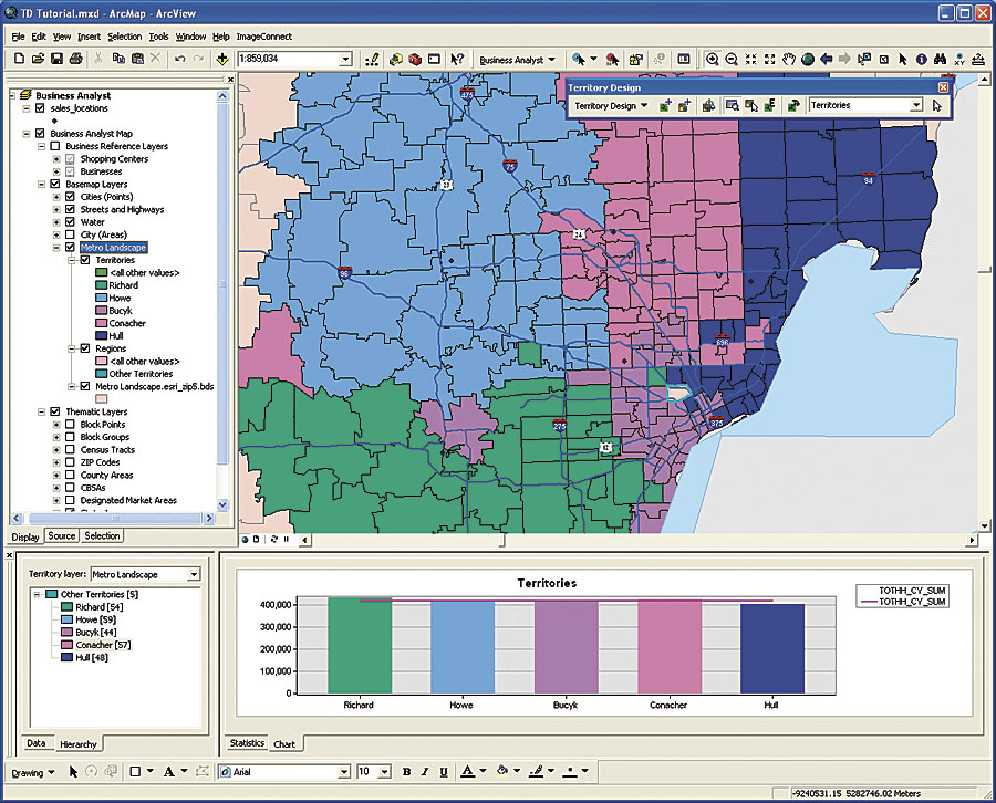
ArcGIS Business Analyst desktop software combines Esri's leading GIS technology with extensive business, demographic, and consumer household data to assist users with critical decisions, such as analyzing the market and competition, finding the ideal site for a new business location, or targeting direct mail. ArcGIS Business Analyst allows users to perform sophisticated business analyses in one easy-to-use application. By combining information such as sales data, demographics, and competitor locations with geographic data such as census boundaries, territories, and store locations, ArcGIS Business Analyst helps users better understand their market, their customers, and their competition. For the past three years, sales and usage of ArcGIS Business Analyst desktop analytic software have grown significantly in industries that perform marketing analytic applications. This pattern of growth is expected to continue as more organizations discover the unique capabilities of ArcGIS Business Analyst. Building on this success, the release of ArcGIS Business Analyst 9.2 includes more performance improvements and additional functionality. Based on client feedback, performance has been improved for report generation, data aggregation, drive times, and geocoding. Noteworthy new features include a unique territory design toolbar with automatic balancing, a capability normally developed as a stand-alone application; a new custom report wizard that makes it easier to use the Crystal Reports interface; a new geocoder using the Tele Atlas/TomTom address point database; and ImageConnect premium imagery from GlobeXplorer, an Esri Business Partner. Territory Design ToolbarArcGIS Business Analyst clients have requested a tool to help them define sales territories and analyze territory performance. Many organizations define and assign areas solely by size. An area's sales potential may be related less to the geographic size than to the underlying demographics or potential consumer expenditure characteristics of the customers who live there. Performance goals assigned for potential territories mean much more when they are based on quantifiable reasoning instead of an adjustment from last year's numbers. ArcGIS Business Analyst 9.2 demographic and consumer expenditure data can be used with location information for current customers and sales territories to set more justifiable and achievable performance goals.
The Territory Design toolbar, a complete territory management application in ArcGIS Business Analyst 9.2, can be used to create, edit, and manage sales, account management, and service territories. This tool provides the ability to automatically generate and balance territories by several methods to compare area sizes, drive times, demographic characteristics, consumer expenditure variables, multiple weighted variables, or a user's own data. With this information, a territory's sales potential is known before the area's sales goals are defined. Territory design functions are completely integrated with the ArcGIS Business Analyst 9.2 datasets, enabling users to create territories with geographies, including states, ZIP Codes, census tracts, counties, and block groups. To develop, edit, and manage territories, users can also apply custom polygon data in any format supported by ArcGIS. Hierarchies can also be built to sum territories into regions. Custom Report WizardTwo options for generating presentation-quality Crystal Reports are now available in ArcGIS Business Analyst 9.2 software. Users can continue to generate reports with the Crystal Reports Designer or use the custom report wizard and a selection of standard report templates to develop their own customized reports. Users can now simply drag and drop fields from ArcGIS Business Analyst data or custom data into one of the standard templates, then add percentages, averages, or index calculations to build the desired custom report. Users can also edit report elements, such as style, color, and font, with the Advanced Editor feature. Also included is the ability to combine several different reports into a single report booklet format. Two new client-requested reports have been added. The Mean Store Center report enables users to compare an existing store location to a theoretical "best" store location that minimizes the distance to a current set of customer locations. The Summarize Points report uses any polygon layer to summarize a point count and all field values in each polygon, append results to the polygon layer, and generate a report with the summarized results. New Geocoder and Faster Drive TimesEsri's new geocoder in ArcGIS Business Analyst 9.2 is significantly faster and integrates an address-based approach with more than 40 million residential and commercial U.S. address records from the Tele Atlas/TomTom address point database. To improve geocoding precision, an actual structure location is the primary match method followed by the street address; then the ZIP Code; and, finally, the city/state. Drive times, drive distances, and routing calculation times in ArcGIS Business Analyst 9.2 are faster using the StreetMap routing method to produce somewhat more generalized areas. To create highly detailed areas, apply barriers, or use other ArcGIS Network Analyst features, the ArcGIS Network Analyst method can be selected. Project Explorer and GlobeXplorer Premium ImageryProject Explorer, a new data management tool in ArcGIS Business Analyst 9.2, is provided for easy retrieval of all layers associated with a particular project or in creating new projects. Project Explorer catalogs all customer layers, store layers, trade areas, study areas, and analyses. Previously created layers can be easily dragged and dropped from Project Explorer into new projects. Users can also share projects among computers with the Export/Backup Project feature. The ImageConnect Premium Imagery toolbar from GlobeXplorer has been upgraded in ArcGIS Business Analyst 9.2. This option integrates premium-level, georeferenced satellite and aerial photos from the GlobeXplorer online database into ArcGIS Business Analyst 9.2. This georeferenced premium imagery is of more recent vintage than the standard imagery and shows the results of any recent construction-related changes in an area. All these improvements have been made in response to client requests for improved performance and functionality. Performance has been enhanced for the reporting, data aggregation, drive times, and geocoding applications. The new features for territory design with automatic balancing; a custom report wizard to improve easier use of the Crystal Reports interface; a high-speed, more accurate geocoder using the Tele Atlas/TomTom address point database; and the ImageConnect premium imagery from GlobeXplorer all contribute to produce a greatly enhanced ArcGIS Business Analyst 9.2 software product. More InformationFor more information about ArcGIS Business Analyst desktop software, visit www.esri.com/ba. |