Spring 2007
Spring 2007 |
|||||||
|
|
|||||||
Bring Back Geography! |
|||||
|
By Jerome E. Dobson
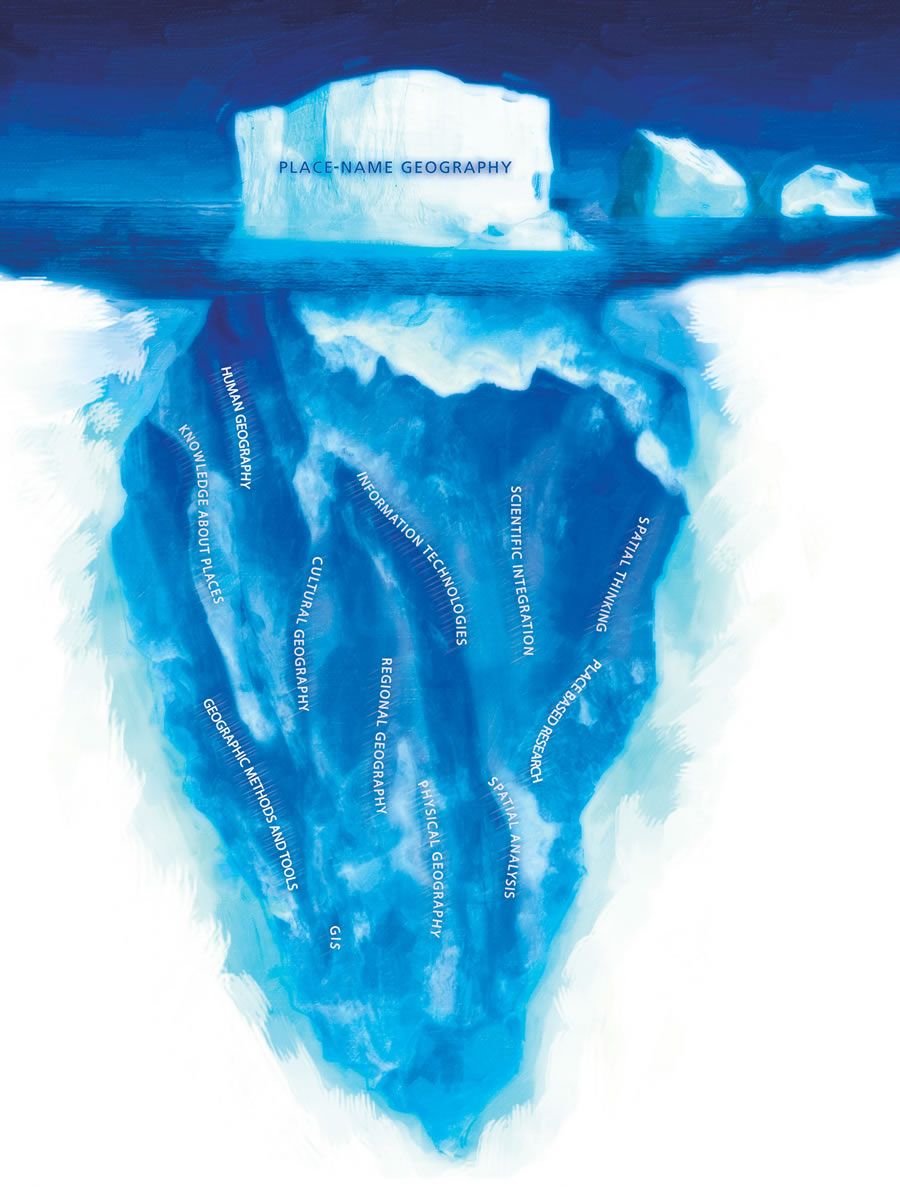
Quiz after quiz has shown that kids today don't know where any place is. How often have you heard this lament about "geographic ignorance" or "geographic illiteracy," as it is commonly called? Now, take that complaint and turn it around. What does it say about geography? It says geography means knowing where places are. That's what geographers call "place-name geography." It's vital, but it's the least of what we expect budding geographers to learn. Geography is more than you think. Geography is to space what history is to time. It is a spatial way of thinking, a science with distinctive methods and tools, a body of knowledge about places, and a set of information technologies that have been around for centuries. Geography is about understanding people and places and how real-world places function in a viscerally organic sense. It's about understanding spatial distributions and interpreting what they mean. It's about using technology to study, in the words of the late professor J. Rowland Illick, "why people do what they do where they do it." Geography is a dimensional science and humanity based on spatial logic in which locations, flows, and spatial associations are considered to be primary evidence of earth processes, both physical and cultural. Its hallmarks are spatial analysis, place-based research (e.g., regional studies, area studies, urban studies), and scientific integration. The familiar litany also implies that geography is just for kids, something you learn in elementary school or high school if you're lucky, and use for the rest of your life without any need for new learning. Does geography really matter for grownups? Of course it does. Geographic knowledge, understanding, and skills matter, for instance, in formulating foreign policy, designing and using GIS, and just about everything else in society that involves locations, movements, and flows. An Excellent InventionGeography was founded at least 2,500 years ago and advanced by Greek, Roman, and Chinese scholars throughout the Classical Age. Prior to the Renaissance, geography and astronomy—interrelated, spatially oriented disciplines—were preeminent sciences. For a thousand years, geography was recognized and valued. "How excellent inventions are geography, arithmetic, astrology, and the rest!" wrote Saint Augustine in The City of God in the early 5th century. Then came the Great Interruption of the Middle Ages, and geography became a fantasy. For a thousand years, its real body of knowledge was preserved by Irish monks and advanced by Arab and Persian scholars. Its rediscovery by European scholars was central to the enlightenment of the Renaissance. It thrived from c. 1450 to 1948 based on exploration, from c. 1600 to 1900 based on the information needs of westward expansion, and from c. 1915 to 1947 based on geopolitics. Its accomplishments include the following:
The Purge of Geography
Soon after World War II, however, geography was purged in the United States, and the impact continues today. From 1948 to 1988, the discipline was expunged at the University of Chicago, Columbia, Harvard, the University of Michigan, Northwestern, Stanford, Yale, and other esteemed American universities, oddly even during periods when universities were expanding faster than at any other time before or since. In truth, nobody knows why geography was targeted on such a broad scale. For decades, there have been no geography departments in the Ivy League, except Dartmouth's undergraduate department. Of the top 20 private universities in the United States, only two currently have geography departments, though 15 of the top 20 public universities do. The purge was an American phenomenon. In the United Kingdom to this day, Oxford and Cambridge universities continue to have strong academic programs offering doctoral degrees in geography. Lately, geography is enjoying a resurgence due to the phenomenal success of GIS and the need for better understanding of foreign lands and peoples in this age of globalization and geopolitical turmoil. Peers in other disciplines now respect, and some are adopting, our hallmarks—spatial analysis, place-based research, and scientific integration. What this resurgence means is that existing geography departments are adding faculty and new graduate degrees. Unfortunately, however, only four new undergraduate degree programs have been added in the past 10 years, and only one new department is being discussed at present in a serious way. As incredible as it may seem, the purge continues, and there will be a net loss this year as Southern Oregon University closes its geography department. The panoply of disciplines must evolve, of course, and obsolete ones should disappear. Geography, however, was cut down in its heyday, just as it was shortly after Saint Augustine's effusive compliment. This not-so-great interruption from 1948 to the present is disturbingly reminiscent of the great one in the Middle Ages. I, for one, take enormous pride in how my discipline handled its fate. For half a century, geography's body of knowledge and pool of expertise have been preserved and advanced by American scholars in state universities and a few private universities and by foreign scholars. These geographers in exile have, in effect, "preserved the scrolls" as Irish monks did in the Middle Ages. Better yet, they continued to advance the field and contribute to science and society in impressive fashion. Their collective impact is far greater today than one would expect based on their diminished numbers and institutional base. Meanwhile, geographic education has been nearly eliminated from K–12 curricula in the United States. In elementary school, it has been lost in a mishmash called "social studies" that neglects physical geography and spatial thinking. Each semester, I ask my students in a large introductory class how many of them have ever had a geography course before at any level, and less than 10 percent raise their hands. Advanced Placement (AP) enrollments in geography are rising in high school, but the absolute number remains small (21,000 in 2006). Most matriculating students do not even know it is possible to earn a college degree in geography. The No Child Left Behind program provides funds to improve the teaching of all the essential subjects identified—except geography. Congress said geography is essential and then provided not a single dollar for it. The situation in government reflects what happened in academia. In ancient China, the Chou emperor had his geographer-royal. Louis XV had his geographer. The Continental Congress appointed its official geographer. President Wilson had his geographer (Bowman). President Roosevelt had his geographer (also Bowman). Since World War II, however, no U.S. president has had a geographer. Again, the deficiency is a distinctly American phenomenon. In the United Kingdom, Prince William, heir to the throne, is himself a geographer, having graduated from St. Andrews University in 2005 with a master's degree in geography. In the first half of the 20th century, geopolitics was a major focus of academic research, especially by geographers, and its influence on real-world politics was enormous. In the second half of the century, geopolitics gave way to political science and international affairs. Now, 9 of the top 15 schools of international affairs in the United States reside in universities without geography departments. The late Bill Wood, geographer of the United States, compiled a list illustrating that point and shared it with me shortly before he died. He was deeply concerned by the lack of geographic knowledge among graduates in international affairs and a similar lack of political understanding among geographers. He wanted to hire people with a broad understanding of geopolitics—both geography and politics—at the U. S. Department of State and could not find them in the labor pool. As one indication that geopolitics matters, consider geographer Bowman's warning in 1949, "we can lose our shirt in the swamps and canyons of the hinterlands" of Southeast Asia. Two decades later, the United States went to war in Vietnam fully committed to George F. Kennan's doctrine of containment, but Bowman's "scroll" was lost, and his warning never entered the debate. During my 26-year career at Oak Ridge National Laboratory and 6 years at the University of Kansas, I have participated in scores of meetings among insiders who provide decision support to foreign policy makers and military strategists. For about 2 years, I've sensed an historic opening for the restoration of geography. Many insiders now openly admit that geographic understanding is sorely missing from their deliberations, though only a few know to call it geography. As I listen to their Wilson's plight is especially instructive. On the eve of World War I, he knew the United States was poised to become a world power. The Great War and subsequent peace would be his nation's debut on the global stage. He relished the role of leading man, but who would play his supporting cast? For 140 years, America had practiced isolationism. No one in government—not even the officers and analysts of the Department of State or Military Intelligence—was ready to analyze foreign intelligence or face sophisticated European negotiators. Wilson, scholar that he was, recognized his problem as being geographic and called on the American Geographical Society (AGS) for help. AGS director Bowman led The Inquiry, a massive analysis of foreign intelligence staffed by 150 scholars from geography and other disciplines. Their task was to collect and analyze the information that would be needed to establish a "scientific" peace at war's end. As part of The Inquiry, the American Geographical Society was responsible for drafting Wilson's famous Fourteen Points, one of the most reassuring and effective policy statements ever written. When Wilson and the American delegation left for France aboard the USS George Washington, Bowman sailed with them. On arrival, Bowman pulled off an amazing bureaucratic coup, and Wilson decreed that analysts from the Department of State, Military Intelligence, and Central Bureau of Statistics would report to him through Bowman. In January 1919, AGS geographers and cartographers, led by Mark Jefferson, turned out more than 300 maps per week based on geographic analysis of The Inquiry's massive data collections covering language, ethnicity, resources, historic boundaries, and other pertinent information. America's delegation became the envy of Versailles. President Roosevelt, too, appreciated geography and even served on the Council of the American Geographical Society for more than a decade. During World War II, Bowman was his closest advisor and one of the top six architects of the United Nations. Bowman was the only individual present from the beginning to the end of the effort to establish the United Nations, and he personally convinced Winston Churchill that one global organization would be better than three regional organizations. During that war, one-third of all academic geographers were called to Washington, D.C., to serve in the Office of Strategic Services (OSS) and other agencies essential to the war effort. Their service, and especially Bowman's powerful role in both wars, adds to our puzzlement over why geography was purged just three years after the war ended and one year after the United Nations' charter. Today, considering our nation's new capacity for rapid warfare, it is worth noting that the American Geographical Society's role in World War I and Bowman's role in World War II had far more to do with peace than war. Knowing the field of peace ahead of time is more important than ever. Continued on page 2 |
 concerns, I sense a striking similarity to the situation that Woodrow Wilson faced in World War I and Franklin D. Roosevelt in World War II. Yet those wars ended in victories viewed today as intelligence triumphs. They found a solution in their day, and current leaders would be wise to ask what it was.