Spring 2007
Spring 2007 |
|||||||
|
|
|||||||
Pakistan Develops Full Potential of Natural Gas Resources with GIS |
|||
Highlights
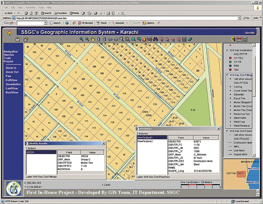
Pakistan's Balochistan Province boasts a formidable landscape dominated by barren, rugged mountains that stretch southward to the Makran, an infamous desert through which Alexander the Great, ruler of ancient Greece, marched his army on its return from conquests in South Asia in 325 BC.
The Greek historian Plutarch described Alexander's perilous journey across the Makran and the hardships that his army endured in his seminal book Parallel Lives: "And [Alexander] returned himself by land through the country of the Orites mountain people, where he was reduced to great straits for want of provisions, and lost a vast number of his men, so that of an army of one hundred and twenty thousand foot and fifteen thousand horse, he scarcely brought back above a fourth part out of India, they were so diminished by disease, ill diet, and the scorching heats, but most by famine." While the harsh environment of nearly 2,400 years ago continues to prevail today, the discovery of rich natural gas fields in 1952 near the city of Sui, in Balochistan, has allowed the province to become Pakistan's center for hydrocarbon exploration. The Sui Southern Gas Company Limited (SSGC), headquartered in Karachi, is the country's leading integrated natural gas company. It operates transmission and distribution systems throughout southern Pakistan in the Sindh and Balochistan provinces. SSGC's Gas Transmission Pipeline Network (gas field to city/town) comprises more than 3,000 kilometers of high-pressure pipeline ranging from 12 to 24 inches in diameter and extending from Sui to Quetta in Balochistan to Karachi in Sindh. The Gas Distribution Pipeline Network (within city or town), which includes more than 120 towns and 930 villages in the Sindh and Balochistan provinces, is organized through the company's six regional offices. The company supplies nearly 350,000 million cubic feet of natural gas to about 1.8 million users through the distribution network totaling approximately 26,000 kilometers of pipeline. SSGC's GIS is being implemented in a two-stage process. The first phase of the project includes the development of a basemap for both its transmission and distribution networks and will be completed by June 2007. After the completion of this stage, staff members will be able to visualize and query the network's georeferenced data for better planning and development within the company. This information will be distributed via the company's intranet-based Web GIS. The second phase will focus on the deployment of the GIS basemap for analytical purposes within the commercial, distribution, transmission, engineering, and management divisions of SSGC, as well as the integration of GIS with SSGC's customer information, SCADA, and enterprise resource planning systems. "SSGC is recognized as the most technology-enabled utility company not only in Pakistan but also in the South Asia region," says Zuhair Siddiqui, IT general manager at SSGC. He adds that SSGC now has the required proficiency to provide advisory services to other companies in Pakistan and the region on IT, as well as optimization and conservation technology. "The entire SSGC GIS system has been developed from scratch in-house, and it is a notable achievement that has been recognized by GIS professionals," says Munawar Baseer Ahmad, SSGC managing director. "The technology flag bearers—the IT Department, and the entire SSGC GIS team—deserve much credit." Because Esri provides a full spectrum of ready-to-use geospatial data products delivered either as Web services or as packaged media, SSGC chose to use several products within the ArcGIS software family, including ArcView for creating GIS projects and developing various mapping products, ArcSDE for spatial data storage and management, and ArcIMS for delivering dynamic maps and GIS data and services via the Web. ArcGIS Engine is being used for creating custom GIS desktop applications. In addition, Esri provides an easy-to-use software interface and comprehensive documentation for all levels of GIS users. Using ArcIMS, SSGC recently developed a Web-based GIS application for Karachi and Hyderabad, two major cities in its franchised area. The application allows SSGC's staff members in its various offices to visualize and query pipeline network information from the same central database for better planning and development. The GIS database was developed from high-resolution satellite imagery (2.5 meters) and scanned paper maps. The data layers include land-use functions, administrative units, water resources, gas pipeline network and fittings, road and railway networks, and major and minor landmarks. According to Syed Ali Naqi, GIS manager at SSGC, "One of the primary objectives of our GIS implementation is to increase efficiency and productivity in our existing operations. For the planning, development, management, analysis, maintenance, and operation of our existing pipeline network, SSGC uses more than 5,000 paper maps. Since our gas pipeline network is continuously expanding, the number of these paper maps is also increasing. Therefore, the day-to-day handling, storage, restorage, and maintenance of these maps are becoming a significant problem. Moreover, these maps have outdated information and can't be combined with each other because of variable scales and several geometric problems. With the implementation of our GIS, these logistical issues will be resolved, and the GIS will provide us with a centralized and seamless asset information system. We want to create and promote an efficient GIS environment here at SSGC that fosters cooperation and geographic data sharing between the various divisions of our company." To develop a strong foundation for an asset information system, SSGC is planning to deploy GIS throughout its entire enterprise using the products from Esri and its partners for analysis, visualization, and decision support. With the rapidly expanding economies of countries in South Asia, plans to develop gas and petroleum pipeline grids to redistribute these resources throughout the region have been under discussion for many years. The geographic location of Pakistan, along with its own proven natural gas resources and a deepwater port at Gwadar, makes Pakistan a strategic player in any construction of a regional pipeline network. GIS will play a critical role in the development of this infrastructure. Concludes Ahmad, "It is widely recognized that Pakistan is ideally situated to cater to the energy and trading needs of other countries in the region, particularly the landlocked central Asian republics. Moreover, Gwadar, the new port of Pakistan, in the Balochistan Province is expected to provide a secure outlet for the Middle East and central Asia oil and gas supply corridor, as well as for the entire region." More InformationFor more information, contact Syed Ali Naqi, GIS manager, Information Technology Department, Sui Southern Gas Company Limited (tel.: 9221-9021509, e-mail: ali.naqi@ssgc.com.pk, Web: www.ssgc.com.pk). |