Spring 2007
Spring 2007 |
|||||||
|
|
|||||||
Georgia DOT Meets Challenge of How to Update and Maintain Data
Paving the Way to Enterprise GIS |
|||
Highlights
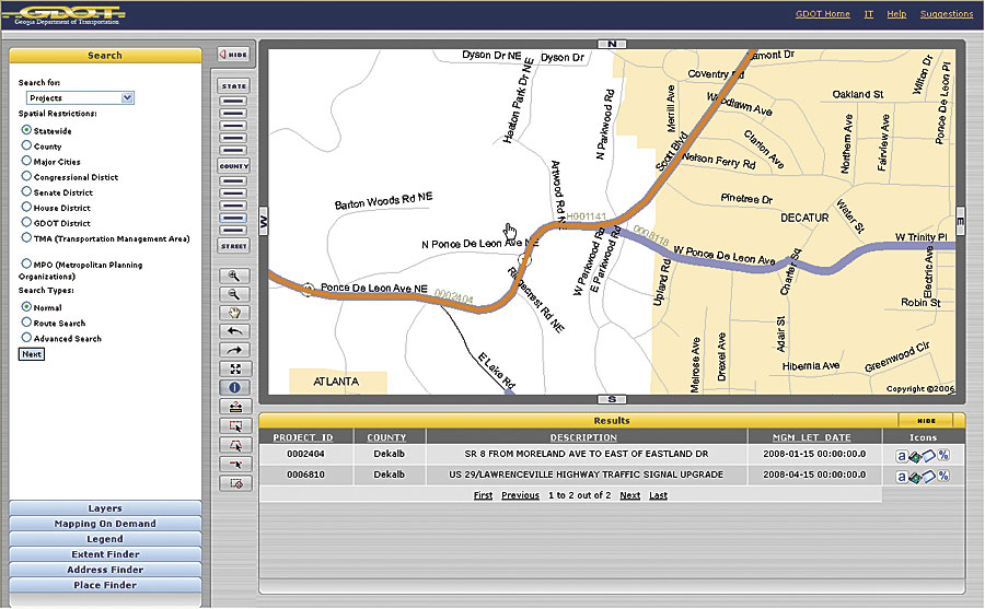
As the amount of GIS data grew, the agency faced the challenge of how to update and maintain the data, as well as leverage it as an asset throughout the agency. With a diverse workforce of 4,000, it could neither train everyone on desktop GIS nor require GIS experience as a hiring prerequisite. GDOT instead set its sights on creating highly visible and easy-to-use applications that made using GIS as easy as using the Internet. To build support for such an undertaking, GDOT implemented a pilot project called Transportation Explorer (TREX). Based on ArcIMS, TREX was designed as a Web application that served as an internal information clearinghouse and allowed the public to search GDOT maps, reports, and plans for all transportation projects in Georgia.
"Most important to the agency's GIS plans, TREX showed that GIS could improve operational efficiency and decision making," says Teague Buchanan, GDOT Enterprise GIS Program manager. As a result, Buchanan's team was given permission to contract with Esri Professional Services to develop an enterprise GIS needs assessment in 2005. The needs assessment identified seven enterprise GIS initiatives, including Mapping on Demand, a system to provide non-GIS users with the ability to create, modify, and print user-defined maps in multiple formats. Mapping on Demand became phase 1 of GDOT's enterprise GIS implementation, and it was accomplished by engaging Esri Professional Services to completely redesign the TREX architecture framework to work with ArcGIS Server 9.2 Java Application Development Framework (ADF) for ArcIMS and ArcGIS Server. The Java ADF provides standards for configuring data sources that allow them to be quickly integrated into TREX. As a result, the newly redesigned architecture integrated 12 internal transportation databases that contain maps, reports, photos, and plans, all of which can be retrieved in real time. The framework also makes it easy for GDOT to support and extend the system as needed. "The new TREX framework design has great benefits for GDOT programmers tasked to keep up with the growing demand for geospatial services," says Buchanan. Laying the Foundation for Enterprise GISThe redesign of TREX has laid the foundation for GDOT to deliver services and information needed to support departmental business processes. "Many tasks that used to take days and weeks can be accomplished in minutes using TREX," adds Buchanan. "We've seen an increase in timeliness of response to data and information inquiries, which has also resulted in a decrease in the department's cost of responding." Additionally, agency officials have noted an increase in the amount of citizen participation. The considerable amount of information available publicly has increased the transparency of GDOT's work, a mutually beneficial outcome for both GDOT and the traveling public. "Our greatest satisfaction is watching people use our application in their day-to-day business," comments Buchanan. "It's very gratifying to know that our application is providing a valued service to the public and our transportation partners." The real return on GIS investment for GDOT is in information sharing and broadening access to the data to its staff and the public. TREX proved the benefits of adopting enterprise GIS architecture and paved the way for further implementation. Next StepsGDOT plans to continue to implement enterprise GIS by building upon the new TREX ArcGIS Server 9.2 framework through projects that include upgrading NAVIGATOR, creating a tracking and dispatching system for roadside assistance vehicles, allowing distributed data collection and editing, and creating SOAP/XML Web services. During the past five years, GDOT GIS has grown from 60 GIS desktop product users to more than 12,000 users (including the public) of GIS data and services. GDOT plans to further leverage its investment in GIS to reduce the cost and time to deliver transportation project planning and design functions. Frameworks for rolling out multiple GIS services from central offices to statewide field/mobile operations are in the planning process. "With our enterprise GIS plans, GDOT is delivering key benefits to its transportation partners and the public," concludes Buchanan. More InformationFor more information, contact Teague Buchanan, GDOT Enterprise GIS Program manager (e-mail: Teague.Buchanan@dot.state.ga.us); Eric Floss, Esri project manager (e-mail: efloss@esri.com); or Wittaker Mathot, Esri Java development team (e-mail: wmathot@esri.com). |
 In the early 1990s, while preparing for the 1996 Olympic Games in Atlanta, Georgia, the Georgia Department of Transportation (GDOT) faced the challenge of providing intelligent transportation systems (ITS) that could handle the influx of more than two million visitors attending the games. In its first foray into GIS, GDOT used ArcInfo to support the online Georgia ITS NAVIGATOR, which to this day provides real-time information on traffic congestion, highway incidents, and construction activities. With the success of that initial application, GDOT expanded its use of GIS to a number of other applications, including digitizing paper maps, mapping all public-access roads, and participating in the creation of a statewide basemap.