Spring 2007
Spring 2007 |
|||||||
|
|
|||||||
Several New Titles from Esri Press |
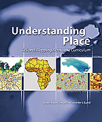
|||
This summer, several new titles from Esri Press will present innovative ways for industry professionals, teachers, researchers, and students to embrace GIS as the technology of choice to perform better and more accurate analyses. Authored by renowned GIS experts, these lavishly illustrated, reader-friendly editions will be important additions to any GIS reference collection. Smart Land-Use Analysis: The LUCIS Model—Written by Margaret Carr and Paul Zwick, this guide is required reading for anyone who must understand the intricacies of the land-use conflict identification strategy (LUCIS). The LUCIS model uses the geoprocessing framework in ArcGIS ModelBuilder to analyze the suitability and preference for major land categories, determine potential future category conflicts, and build future land-use scenarios. ISBN: 978-1-58948-174-9, 264 pp., $49.95. Thinking About GIS: Geographic Information System Planning for Managers, Second Edition—Dr. Roger Tomlinson, world-renowned authority on GIS, recently updated his classic with a new preface, an expanded index, and new information on implementing a GIS that meets an organization's requirements and expectations. Planning teams can use this methodology to assess their needs, implement a successful GIS, and bridge the gap between technical and nontechnical teams. ISBN: 978-1-58948-158-9, 266 pp., $24.95. GIS Tutorial: Workbook for ArcView 9, Second Edition—As more commercial, government, and education organizations embrace GIS, demand grows for effective training. Updated for ArcGIS 9.2, this workbook combines GIS tutorials with exercises that progress from basic applications to more difficult functionalities. Tutorials teach GIS users how to create maps, collect data, and develop advanced analyses with geoprocessing tools. A fully functional 180-day trial version of ArcGIS Desktop 9.2 software, data for the exercises, and Web-based teacher resources are included. ISBN: 978-1-58948-127-5, 374 pp., $69.95. GIS Tutorial for Marketing—Real-world scenarios and easy-to-follow exercises combined with valuable information provide an essential resource for anyone who solves vital business and marketing problems with ArcGIS Desktop software. Professionals and students will learn how to incorporate GIS into marketing applications, such as site selection and evaluation, customer profiling, market planning, and target marketing. A 180-day trial version of ArcGIS 9 software with extensions, a data CD with report templates, tutorial datasets, and sample data complete this comprehensive marketing applications resource. ISBN: 978-1-58948-079-7, 428 pp., $69.95. Research and Theory in Advancing Spatial Data Infrastructure Concepts—The latest research from international experts, compiled by Harlan Onsrud, president of the Global Spatial Data Infrastructure Association, offers insight into a possible direction for spatial data infrastructures (SDI). Examples will enhance understanding of this important topic. This information will be indispensable to anyone interested in theoretical SDI developments. ISBN: 978-1-58948-162-6, 322 pp., $24.95. Building European Spatial Data Infrastructures—Written by Ian Masser, a world leader in spatial data infrastructures, this book explores emerging European use of SDIs and European Union efforts to create a framework for a multinational spatial information infrastructure. Tasks to build European SDIs are described in concise, practical terms along with implications and key issues for future SDI debates. ISBN: 978-1-58948-165-7, 104 pp., $24.95. Understanding Place: GIS and Mapping Across the Curriculum—The successes and challenges of teaching college-level GIS are candidly discussed by contributors to this informative volume. Instructors can benefit from experiences of other faculty who use GIS to broaden students' understanding of natural sciences, social sciences, arts and humanities, and other departments. Teachers can also learn how to encourage student involvement by using GIS to manage, analyze, and visualize information. ISBN: 978-1-58948-149-7, 308 pp., $49.95. Arc Marine: GIS for a Blue Planet—As oceans become increasingly valuable resources, accurate marine information is critical. Marine researchers have developed a data model that supports seafloor mapping, fisheries management, marine mammal tracking, and other issues. Dr. Dawn J. Wright and other marine scholars present initial results of this model, which provides a structure for storing and analyzing marine data and helps users create maps and three-dimensional scenes of the marine environment. ISBN: 978-1-58948-017-9, 216 pp., $47.95. Cartographic Relief Presentation—Within the cartography discipline, Dr. Eduard Imhof's book is considered a classic. A unique display of analysis and portrayal, this English-language version carefully preserves Professor Imhof's forthright commentaries and presents his incomparable illustrations in a form of cartographic communication to anyone interested in mapmaking and cartography. ISBN: 978-1-58948-026-1, 412 pp., $59.95. Standards for Success: GIS for Federal Progress and Accountability—This volume describes how government agencies successfully use GIS to improve their geospatial analyses. The case study format details how agencies use GIS to improve processes, reduce maintenance costs, and produce more accurate maps of vulnerable areas. ISBN: 978-1-58948-047-6, 112 pp., $24.95. More InformationVisit www.esri.com/esripress for the availability dates of these books, ordering information, and a listing of other available titles. |