Spring 2009
Spring 2009 |
|||||||
|
|
|||||||
USGS Scientists Plan Life-Saving Disaster Response
GIS Versus the Volcano |
|||||
Highlights
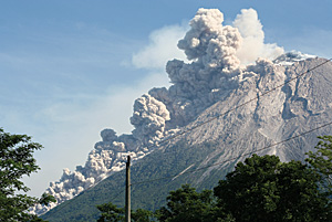
More than 1,300 people living on the slopes of Indonesia's Mount Merapi were killed when the volcano erupted in 1930. As one of Indonesia's youngest and most active volcanoes, the aptly named "Mountain of Fire" keeps nearby villagers, government officials, and volcanologists on alert.
Years after the deadly Mount Merapi eruption, scientists with the U.S. Geological Survey (USGS) Volcano Disaster Assistance Program (VDAP) can now predict volcanic activity and plan life-saving disaster response. A VDAP mobile volcano-response team was established by USGS and the U.S. Office of Foreign Disaster Assistance following the eruption of the Nevado del Ruiz volcano in Colombia that claimed more than 23,000 lives in 1985. "We work closely with local scientists to plan the best ways to improve the volcano-monitoring networks, install instruments, interpret monitoring data, and assess volcanic hazards," says Julia Griswold, a VDAP scientist. In volcano-prone territory, such as Indonesia, scientists are able to use satellite images, along with data from continuous monitoring, to detect changes in volcanic activity. Imagery and data are combined with the use of GIS technology to determine areas that will be clear of lava and mud flow in order to establish evacuation shelters in safe locations. With 129 active volcanoes in Indonesia, disaster planning is a hefty task, but one made simpler with the use of GIS-driven mapping and database technology. USGS scientists rely on ArcGIS Desktop to research, analyze, and forecast areas prone to volcanic hazards. "The ability to illustrate highly technical information or scientific concepts to public officials in a timely, effective manner really helps avert disasters," adds Griswold. ArcGIS Desktop extension tools provide viewshed analysis, grid algebra, and slope functions that are simple but critical for working in remote areas where access might be almost impossible. In 2006, when Mount Merapi again began to rumble, pouring out lava and spewing hot volcanic ash and smoke, authorities ordered mass evacuation. With the support of monitoring data from VDAP scientists, Indonesian authorities established an escape route and set up shelters away from predicted lava flow and noxious gases. Although the eventual 2006 eruption was considered mild—the 2.5-mile cloud of hot ash and gas never reached populated areas—volcanologists warned that the volcano could collapse at any time. "Knowing the location of the shelters beforehand helps us prepare support for the evacuation process, such as improving the infrastructures in the area in terms of roads and buildings, as well as establishing other supporting facilities, such as health clinics," says Dali Ahmad, a volcanologist at the Indonesian Center of Volcanology and Geological Hazard Mitigation (CVGHM).
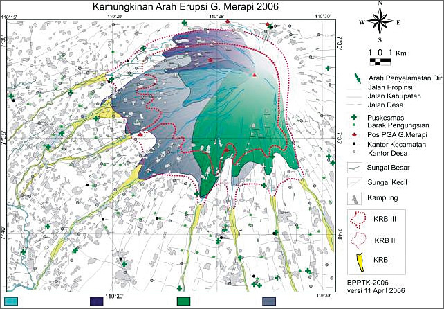
Scientists at CVGHM partner with the USGS team to save lives in the wake of a volcanic eruption in Indonesia. Within the GIS, CVGHM can query geological data, perform analyses, and store the results in a database that is accessible to other institutions and local government. Ahmad and his team can view 3D seismic epicenters beneath the volcano in order to monitor seismic changes in earthquake magnitudes and hypocenters for an indication of ascending magma or the extrusion of lava at the surface. Population centers or critical infrastructure can be layered in the GIS relative to the position of volcanoes to plan evacuations. Hazard zones modeled with GIS programs and topographic data predict areas of potential inundation by a lahar (a muddy landslide of volcanic debris and water). "We use GIS to design maps of predicted disaster areas, and we make the maps available as a reference for the policy makers—especially at local government level—to assist them in urban planning activities," explains Ahmad. "This way, the local government can better plan development in the areas. They can reduce or eliminate growth in areas that are prone to disasters and concentrate on the development of safe areas." Lesson LearnedVDAP's quick response to the catastrophic eruptions of Mount Pinatubo in the Philippines in 1991 ranks as its most notable success. A quick examination of the geologic record at Mount Pinatubo indicated the volcano's recent history of producing large, explosive eruptions. The assessment helped identify hazardous areas around the volcano before its cataclysmic eruption on June 15, 1991. VDAP and scientists from the Philippines noted developing unrest early enough to establish a monitoring network and complete a hazard assessment. They were able to provide accurate eruption forecasts for local government officials and U.S. military leaders. Evacuations and other civil-defense actions saved thousands of lives and hundreds of millions of dollars in U.S. military aircraft and hardware. Since the 1991 eruption of Mount Pinatubo, VDAP has responded to many volcanoes in Central America, South America, the Caribbean, Africa, Asia, and the South Pacific. The evolving volcano-monitoring techniques developed by USGS scientists and the experience gained by VDAP scientists responding to volcanic crises overseas help scientists protect people and property from future eruptions. More InformationFor more information, contact Julia Griswold, geologist, USGS (e-mail: griswold@usgs.gov, tel.: 360-993-8949). |