Spring 2009
Spring 2009 |
|||||||
|
|
|||||||
No-Cost GIS Provides Advanced Analysis and Visualization Tools to Decision Makers
Goochland County Creates Emergency Management Incident Interface |
|||||
|
By Qiana Foote, Goochland County, and Lowell Ballard, Timmons Group Highlights
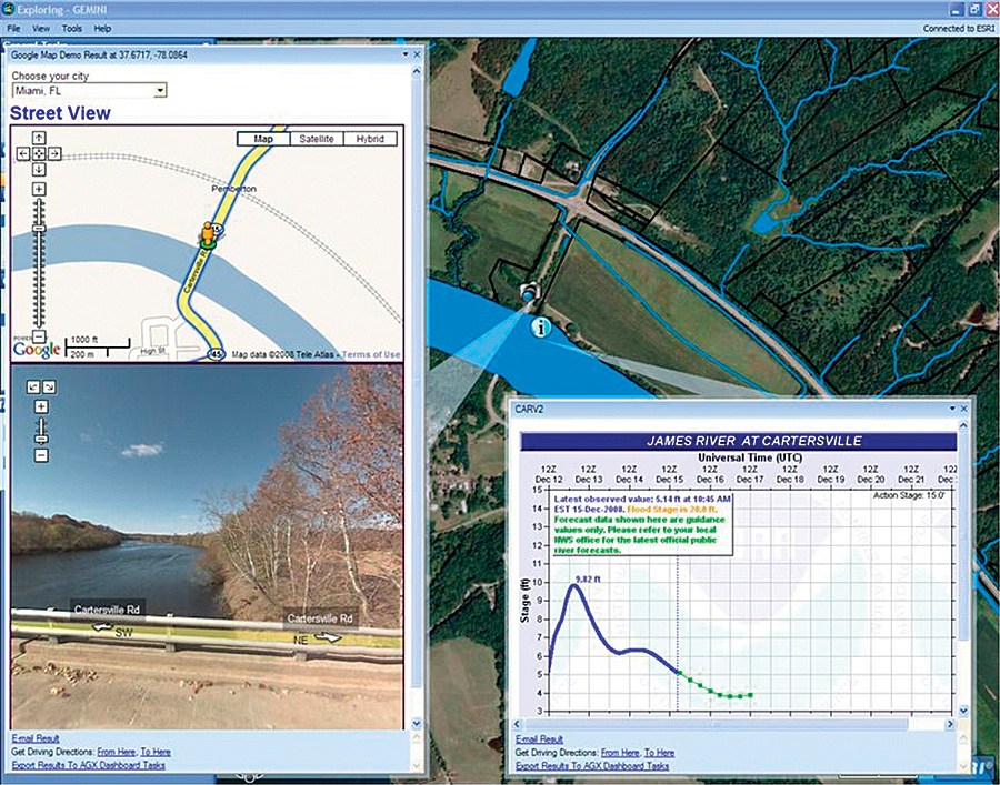
Goochland County is located in central Virginia, 15 miles west of Richmond and 30 miles east of Charlottesville. Its nearly 300 square miles are bound by Interstate 64 to the north and the James River to the south. The county's approximately 20,000 residents enjoy the natural beauty of a rural landscape with views of the James River Valley and the rolling hills of the Virginia Piedmont. The county is in relative proximity to a major nuclear power plant and conducts and participates in joint training exercises to plan for various what-if scenarios. Due to its proximity to major population centers, the county is continuing to grow at an ever-accelerating pace. In responding to the needs of this growth and laying the foundation for future responsible development, the Goochland County GIS Office has built and maintained a robust GIS infrastructure. To be in the best possible position to respond to and work with regional stakeholders in an emergency situation, the county desired to have a tool that leveraged the investment made in GIS while providing an easy-to-use interface.
Having the ability to consume, share, and visualize information across political boundaries is critical in deciding how to respond to situations that may affect an entire region and where resources may need to be pooled in a response. The use of geospatial technologies in emergency planning, response, and communications is widespread, is well documented, and exists in many capacities. Geospatial tools are most useful to planners and responders if they possess the ability to quickly consume and display information to facilitate the decision-making process. A number and variety of software applications exist that assist emergency managers in various ways. The county selected an ArcGIS Explorer software-based solution after a review of available technologies that might solve its need to efficiently visualize and effectively analyze data in a highly dynamic and fluid Emergency Operations Center (EOC) environment. The county consulted with Timmons Group (an Esri Business Partner in Richmond, Virginia) during the evaluation of possible solutions, then chose the company to build and scale the capabilities of ArcGIS Explorer to meet its requirements. This task-based approach facilitates inclusion of new capabilities (e.g., plume models, data feeds) without the overhead of seat-based license management or development scenarios. The solution assists in the visualization and analysis of data among local governments, state agencies, and other data consumers and providers. It also serves as the integration platform facilitating interoperability between ArcGIS Server; ArcGIS Server geoprocessing tasks; and third-party emergency management systems, such as Augusta, Georgia, Esri Business Partner ESi's WebEOC 7 Professional. In an effort to best address the core business requirements of Goochland County's emergency management staff, the county's Emergency Operations Plan (EOP) was reviewed by the GIS Office and the consultant. The EOP and associated action plans around various management scenarios (e.g., hazmat spill) were used as a starting point, driving the development of geospatial tools, tasks, and data feed inclusion. Prioritization and development of spatial tools and data feeds were done with the goal of automating a standard operating procedure from the state-mandated emergency operations plan. The consultant customized and extended the freely available GIS while leveraging ArcGIS Server 9.3 services to meet the county's requirements. The delivered solution enables the county to leverage local basemap data, including parcels, addressing, and utilities, which the GIS Office maintains as part of its normal duties. Additional data available from state and federal GIS data sources is used to provide a more complete and common operating picture of the region.
General scenario or mission-specific tasks for the software, written in C#, .NET, and Python, can be compiled with preloaded data layers and shared easily (via e-mail) with other emergency managers. Tasks can be chained together to solve relevant emergency management business problems. A buffer task, for example, will generate output given certain input (e.g., a point location and distance parameter). The results from this task (i.e., buffer shape) can be passed to an intersect task to determine the parcels, addresses, and landowners potentially affected by an event within the buffer area. The following is an example outlining the steps, in a scenario derived from the county's Emergency Operations Plan, that pass results from one task to another:
The types and nature of ArcGIS Explorer tasks vary. Relatively simple tasks might involve geocoding an address on a road network, whereas more complicated tasks might conduct Sea, Lake and Overland Surges from Hurricanes (SLOSH) model analysis. The Timmons Group built a "digital dashboard menu" as part of this project to allow users of the system to easily incorporate both data and tasks into their work sessions. These � la carte tasks work off of a home server, which manages the appearance of the initial map, data layers, and tasks. Goochland County's solution uses a custom home server that leverages ArcGIS Server technology on the back end, allowing tailored and advanced analytic tasks to be utilized and provisioned easily for end users. One of the county's primary concerns with an emergency management application such as this was the ability to develop and deploy updates with minimal offline time. Another benefit of the use of ArcGIS Explorer is that a home server enables notification as to when a new version of a task is available, thereby reducing the maintenance overhead on the county GIS staff. This development and maintenance model is cost-effective and greatly reduces the time typically required for development, testing, and deployment of updates. Having the ability to communicate data to government agencies at various levels, while still being able to operate in the event that Internet connectivity is lost, is obviously vital for Goochland County during an emergency situation. It helps that the State of Virginia Department of Emergency Management and many Virginia local governments utilize WebEOC software as an emergency management tool. One of the county's deciding factors in selecting ArcGIS Explorer was that it is freely available through Esri and can be downloaded directly from its Web site. Since this lightweight desktop application will be used by various EOC staff, the county needed the platform to be intuitive and to require a minimal amount of training. The available software development kit offers tools to further extend and customize the capabilities of the application, allowing for in-house development if needed. About the AuthorsQiana Foote is the GIS coordinator for Goochland County, Virginia, and president of the Virginia Association for Mapping and Land Information Systems. Lowell Ballard is the director of Geospatial Solutions for Timmons Group in Richmond, Virginia. More InformationFor more information, contact Qiana Foote, Goochland County, Virginia (e-mail: qfoote@co.goochland.va.us). For more information on ArcGIS Explorer, visit www.esri.com/arcgisexplorer. |