Spring 2009
Spring 2009 |
|||||||
|
|
|||||||
In China, GIS-Based Land Registry Aims to Protect Farming Rights and Enhance Food Security |
|||||||
|
By Peter Rabley and Elton Yuen Highlights
This article is part three of a multipart series focusing on GIS-based land and title registry. International Land Systems (ILS), Inc., an Esri Business Partner in Silver Spring, Maryland, teamed with Landstar Digital Technology, Beijing, China, and Esri Canada Limited (Esri's distributor in Canada), Toronto, to demonstrate the feasibility of applying state-of-the-art GIS and surveying technologies to solve one of the most pressing land policy challenges facing China today. Results of the recently completed field pilot may ultimately serve as the foundation for a nationwide GIS-based rural land registration and certification program that will enhance China's ability to feed its people by safeguarding the land rights of its 800 million farmers.
In many countries, food security, farmers' rights, and land registration are inherently related due to the fact that populations are growing while the acreage of arable land is not. In China, agricultural land areas may even be shrinking as local governments at the collective level in rural areas are enticed by opportunities to convert the collective-owned arable lands for development and other purposes. (There are approximately 1.5 billion arable land parcels in rural China.) The central Government of China (GOC) understands that once arable land is converted from farming to another use, it is probably lost forever as a source of agricultural production. To make matters worse, for every land parcel removed from agriculture, a family loses its livelihood and joins the ranks of the rural poor. To protect arable lands and foster sustainable agricultural practices, China has adopted policies and laws aimed at strengthening the land rights of individual farmers. Nearly all arable rural lands are owned by collectives and leased to the farmers by the local collective in contractual lease arrangements that sometimes date back decades. When land disputes arise, it is difficult or impossible for farmers to prove what rights they have to specific pieces of property without adequate documentation. As a result, China established the Rural Land Registration and Certification Pilot Program through its Agricultural University with funding from the United Nations Food and Agriculture Organization (FAO) and World Bank. The objective of this program is to explore and test legal, technical, and organizational solutions for sustainable rural land registration and certification. The long-term goal of the program is to register every rural land parcel and document its correct boundaries and to formally recognize the land tenure of every farming household in the nation. Implementation of a land registration system capable of achieving these objectives will provide a cascading series of benefits across China. For the individual farmer, there will be an enhanced sense of security in the knowledge that parcels he cultivates are protected should ownership or boundary disagreements occur. At the collective level, local officials will have access to accurate landownership records as they make decisions that impact land rights. And just as importantly, the central government will have more accurate rural land-use data at its disposal as it plans and carries out a variety of administrative policies to combat poverty and enhance food security. Commitment to Land TenureThe commitment to sustainable land registration comes from the highest levels of China's central government, the People's Party. The Rural Land Registration and Certification Pilot Program grew directly from 2005 collaboration between the World Bank and the China Development Research Centre of State Council to devise action plans related to the nation's land reform policies. The World Bank in principle agreed to fund future downstream implementation of a land registration system, assuming its technical feasibility could be demonstrated in a field pilot. At the request of GOC in 2006, a team was assembled to test the legal, technical, and organizational aspects of developing a GIS-based rural land registration system in China. This team included international and local partners with a long history of providing GIS consulting services and land registration systems worldwide. The team also sought and received additional funding for the pilot from the Canadian International Development Agency.
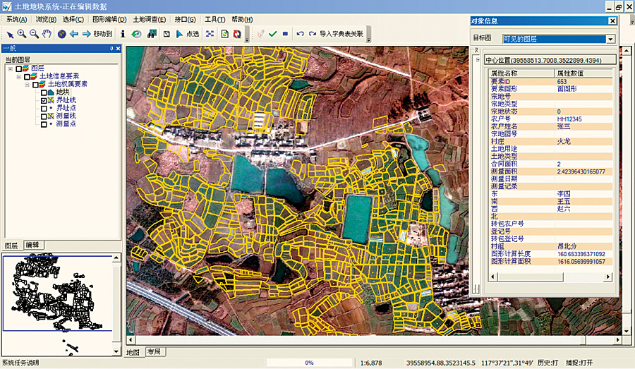
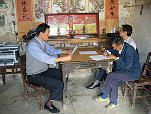
Partners, such as ILS, were selected because they have successfully implemented their cadastral-focused land titling systems in countries around the world using ILS' Land Registry System (LRS), an off-the-shelf suite of applications created specifically to bring modern real property title registration where little or none existed in the past. The project team relied on the LRS system to develop specific workflows and business rules, which would be used to customize the LRS software. The software would then be able to accurately manage the process of registering landownership deeds and agricultural leases and awarding relevant certificates to the owners and leaseholders. Landstar Digital Technology developed a cadastral data management system (CDMS) with ArcGIS software to serve as the GIS mapping solution for the pilot. The CDMS is used to build and store parcels, survey points and lines, and cadastral maps and reports. The Enterprise Services Group (ESG) International of team member Esri Canada was instrumental in acting as the systems integrator for this project and was able to quickly configure the LRS land registry software to accommodate local laws, Chinese language, and documentation, as well as provide integration with the land survey and other spatial data from the Landstar system. Specifically, a Web services interface was developed between the LRS and CDMS systems so that land registry documents and historical data could be accessed by clicking on an individual parcel in the map. A unique identification number was assigned to each parcel survey in the pilot. This ID number is the link between the CDMS maps and the LRS. Stakeholders in the project, including representatives from the Chinese government, evaluated several areas before deciding the pilot would take place in the Anhui Province. Ultimately, they selected two villages—Angbeifen and Longsan—in Shitang Township of Feidong County. Together, these two very small villages contain 89 farming households with rights to work approximately 800 parcels of land. Due to continual subdividing of land for distribution within families, a single agricultural parcel in this pilot area is often less than a mu (one mu equals 1/15 of a hectare, or 666 m2) in size. Preparation for the pilot included a review of the policies, laws, and procedures that would govern the registration and certification process for rural lands. As part of earlier land policy reform activities, FAO had assisted GOC in writing a Land Registration Manual with similar guidelines pertaining to urban land registration. Project participants spent considerable time modifying these existing documents to create a legal framework that could apply to rural lands. Pilot participants gathered available mapping data (provided by the Chinese Ministry of Land and Resources) to load into the CDMS. Already existing were 1:10,000-scale aerial photos, a land-use/land-cover "patch" map created from the aerial photos, and a landownership map of the villages. The ownership map depicted village borders and agricultural lands but did not contain boundaries of individual parcels. A 60-centimeter-resolution QuickBird satellite image was purchased from DigitalGlobe as an additional basemap. The Pilot BeginsThe Feidong County government established a project management office (PMO) and equipped it with a desktop computer running the land registration system (LRS and CDMS), a high-quality printer, and a laptop computer. Trimble China outfitted the PMO survey team with a Trimble S6 GPS Total Station, two Trimble R8 rover GPS units, and other equipment, and Esri provided software required to conduct survey-grade parcel mapping. The first step in the pilot included a visit to the village where the farmers were eager to learn more about land registration and its benefit to them. Many had been issued certificates years before by the Chinese Ministry of Agriculture, which were supposed to demonstrate the farmers' contractual rights to work in specific fields. But in the absence of surveying and mapping techniques at the time of issuance, most certificates lacked proper identification of field locations and boundaries. Next, the pilot participants explored the parcels that would have to be mapped and viewed the small sizes of most fields as a surveying challenge. On the positive side, the majority of fields were bordered by visible boundaries, such as streams, roads, and footpaths. Given the size of the parcels, the team determined that field surveys would have to be performed to an accuracy of 25 to 30 centimeters. The data collection phase of the pilot began in the county PMO where a land registration form was printed from LRS. A team of trained county personnel took one form to each farmer and helped the farmer fill it in with details about himself, his family, lease agreements, parcels, and crops. If the farmer had additional documents relating to his contract, the team collected them for scanning into the land registry.
As this occurred, a mapping team took the Trimble GPS equipment and surveyed the farmer's fields. In some cases, the boundaries were surveyed, while in others, just the corner points were captured. Neighbors were called in to agree on boundaries that were not clearly delineated. With one of the GPS rover units used as a base station, the crews usually achieved the 25-centimeter accuracy desired for the pilot. The surveys often took an entire day because fields worked by an individual farmer are typically noncontiguous and located throughout the countryside surrounding the village. For the sake of comparison, a second mapping team later visited the fields with the laptop computer and attempted to digitally sketch the boundaries of each parcel on the village map underlain by the QuickBird satellite image. Although the satellite image did not have sufficient resolution to meet the desired 25-centimeter accuracy, this method proved to be a fast and efficient technique for creating parcel maps for the majority of parcels because their borders were often so well defined by paths or other visible features. When there was no physical boundary, the boundaries were surveyed. After each interview and survey was completed, staff at the Feidong County PMO loaded the information into the land registration system. They also entered details from the questionnaire into the system and scanned related paper documents. The field surveys were downloaded from the GPS units and laptop into the GIS portion of the registry package. Technicians created accurate parcels and gradually populated the village basemap with the boundaries of every parcel under contract to a farmer. The pilot team printed completed parcel maps and returned to the villages where the farmer and his neighbors reviewed the work. Upon agreement by all interested parties, the parcel map was signed by them and scanned back into the land registry system as an official survey document. If the documentation relating to the farmer and his land contract was also completed, the system printed an official certificate identifying that farmer, the terms of his rights to the land, and legal descriptions of the parcels he farmed. Pilot RecapThe pilot spanned approximately three months in fall 2008. Then project stakeholders examined the results and culled lessons from the endeavor. A national rollout strategy report is under development. The overall reaction from all involved has been very favorable. Among those aspects of the pilot that may be modified if the project is expanded is the use of GPS to survey the boundaries of every field. Given the excellent visual delineation of parcels, it may be more cost-effective to capture boundaries with high-resolution orthorectified image data and rely on GPS to locate corner points. The experiences and lessons gathered from this pilot project are important to formulating recommendations for a national rollout strategy, but they are not nearly enough in their own right to provide the information the Government of China needs to ensure sustainable land registration throughout the country. Given the enormous differences in, and scale of, land issues within China, it is important that the next phase conduct a series of larger-scale pilot projects at different locations within China so that various hypotheses can be tested and appropriate solutions developed. These would include a series of legal, institutional, technical, and financial measures that could create a framework from which a national system can be developed. It will also be important for the government to decide on the appropriate institutional home for registration from which it can prepare the needed human resource base; define regulations and procedures; and establish funding mechanisms, including possible revenue generation to ensure sustainability. China may consider initially rolling out the registration program in coastal or peri-urban regions where land transfers are relatively frequent and land values relatively high. Finally, a sustainable land registration system means not only that it must be financially viable in the long term but that it must also contain no financial, legal, or time disincentives to the farmers themselves to enter and continue to use the system. This means that farmers must also be educated, through far-reaching public awareness programs, about the benefits to them to register their land. This will ensure that the system will continue to capture all subsequent transactions and will reflect a complete and transparent record of land transactions. However, there should be no underestimating the enormous task that lies ahead for China and its people. About the AuthorsPeter Rabley is the president of International Land Systems, Inc. Elton Yuen is the ESG International director of Esri Canada. ILS and Esri Canada have worked together on many GIS-based land registration projects internationally. More InformationFor more information, contact Peter Rabley (e-mail: prabley@landsystems.com). |