Spring 2009
Spring 2009 |
|||||||
|
|
|||||||
|
A column from Members of the Urban and Regional Information Systems Association Take Advantage of Their Knowledge, Expertise, Interest, and Use of GIS Interview Your Customers |
|||
|
By Mary Lynne Lackner, GIS Manager, City of Aspen and Pitkin County, Colorado Regardless of your GIS business (private firm, education, public agency, or software development), everyone has customers—clients, citizens, students, elected officials, employers, department users, colleagues, etc.—and they have needs, expectations, and demands of the GIS department. I am the GIS manager for the City of Aspen and Pitkin County, Colorado. Our GIS department consists of three staff members that support the GIS needs of approximately 600 city and county employees within 53 departments. On the most basic level, we maintain and develop spatial data, provide map production and analysis services, complete special projects, and provide technical support to our GIS customers. Since the majority of our work involves providing information or support to customers, we need to understand our customers to ensure we are meeting their needs.
When did you last talk to your customers? Perhaps it was the initial needs assessment that was performed before GIS was implemented in your organization. Expectations change from early needs assessment interviews to the final implemented GIS program. Changes occur to the project budget, system/database design, project implementation, layer development, and daily operations, and these affect the end customer. How many of your customers are still waiting on the promises made in the needs assessment 5 or 10 years ago? Are your customers expecting services or data that do not exist? How do you know their expectations are being met? Do you ever get weird feedback from a customer who is expecting a product that you have never heard about? Advantages of Customer InterviewsAspenPitkin GIS waited nine years from the initial GIS needs assessment (1989) until our first customer interviews (1998). From the feedback we received after the 1998 interviews, we realized the importance of conducting customer interviews on a more regular basis. We now conduct GIS customer interviews every three years. Here are some reasons why talking to customers is important:
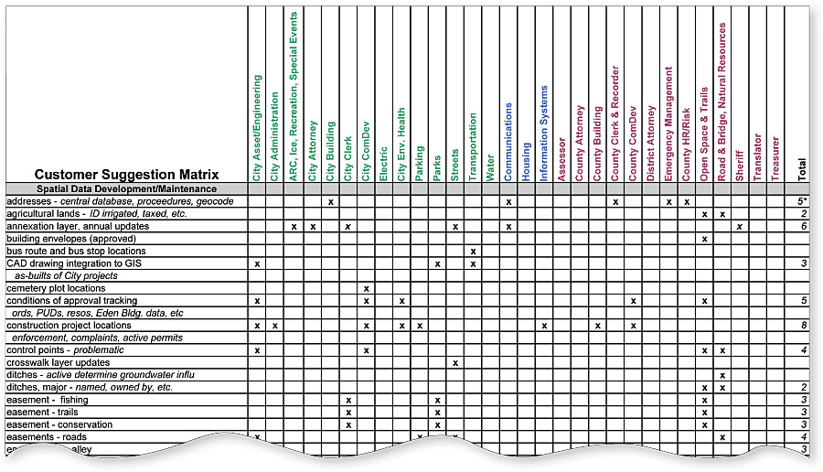
Sitting down face-to-face with each customer takes time. You may ask, "Isn't it easier to send a survey?" No! You learn more in an open two-way dialogue where you and the customer focus on GIS operations and delivery of services. It also builds relationships with customers and reduces surprises in the long run. Interviews can be structured many ways; the objectives of the interview are to listen to the customer's needs, wants, and desires; see if you can collaborate to make a work process or data layer better; identify resources the customer has available; and open an ongoing communication channel. It is also important to identify any "low-hanging fruit," that is, anything that can be done or delivered quickly and easily to the customer. After the InterviewWithin a few days of each interview, provide the low-hanging fruit to the customer. This builds rapport and shows your department's responsiveness to customer needs. Some examples of this could be updating plots of outdated maps, developing a map of the new wireless network sites, providing GPS training to a new employee, adding new spatial data layers to a Web mapping application, or providing a podcast or documentation on how to do an ArcMap function. Customer Suggestion MatrixThe meat of the customer interview should be recorded in the Customer Suggestion Matrix (CSM). This matrix provides a descriptive, visual, and quantified list of all customer suggestions. Ours is categorized into three areas: spatial data development/maintenance, ArcGIS Server/Web improvements, and GIS services, as this best categorizes projects for our environment. The matrix is much easier to review and comprehend than reading a several-page narrative. All organizations are limited by budget, time, and staff resources. The CSM is a very useful document to assist decision makers, staff, and customers to determine where to spend these finite resources. Once all interviews are complete, the CSM project list is quantified. Time and cost estimates are provided, projects prioritized, and funding identified. Customer suggestions related to financial support, staff availability, and customer participation are also studied. Once these factors are considered, GIS staff can now prioritize the projects. SummaryTake the initiative to talk to your customers; they appreciate the time you take to learn about their operations and needs, and you learn how you can improve GIS services. Quantifying customer suggestions into a matrix creates an easy-to-read visual and descriptive summary of all potential projects. This is a practical tool that assists in prioritizing multiple projects, can be referenced during the year as other projects are proposed, and will help in deciding what projects should be completed when funding becomes available. About the AuthorMary Lynne Lackner, GISP, has been with the City of Aspen and Pitkin County for 20 years and has been the GIS manager for the last 10 years. Being in a small GIS department with large customer expectations, she finds herself challenged and rewarded by the experience. More InformationFor more information, contact Mary Lynne Lackner, GIS manager, City of Aspen and Pitkin County, Colorado (tel.: 970-920-5106, e-mail: mary.lackner@ci.aspen.co.us). |