Spring 2009
Spring 2009 |
|||||||
|
|
|||||||
Maryland Improves Government Transparency, Accountability with GIS |
|||||
On February 23, 2009, President Barack Obama addressed the National Governors Association in the State Dining Room at the White House. He discussed the recently passed American Recovery and Reinvestment Act and the positive impacts it will have across the nation. He also noted efforts that governors have taken to create change in their states and improve the lives of residents. Highlighting the work of the governors of Maryland and Virginia, the president said, "Instead of passing the buck on accountability and efficiency, governors like Martin O'Malley and Governor Kaine have revolutionized performance management systems, showing the American people precisely how their governments are working for them." In Maryland, O'Malley is using GIS to accomplish these goals. Since taking office in 2007, the innovative O'Malley has initiated powerful GIS-based performance measurement applications to improve operations and communication with the public. StateStat was the first, then came BayStat; GreenPrint; and, most recently, MD iMap. MD iMap (mdimap.com/imap) also provides an authoritative online basemap of Maryland and supports the other programs. Data-Based Decision MakingPrior to becoming governor, O'Malley was mayor of Baltimore. In that position, he launched the successful GIS-based performance accountability program CitiStat. With the clear picture of city government performance that CitiStat provides, leaders could more strategically plan budgets and manage projects. This data-driven system led to a 40 percent reduction in violent crime by the time O'Malley left office. Additional CitiStat successes included 48-hour guarantees to address complaints from citizens about potholes with a 98 percent success rate, a 65 percent reduction in the number of children with lead poisoning, and a reduction in wait time after a citizen requested cleaning and boarding of a vacant house from eight months to 14 days. StateStat (www.statestat.maryland.gov) is built on the same principle of examining accurate and timely data to assess and improve government performance. Weekly, biweekly, or monthly, state agency representatives meet with the governor's senior staff to discuss the agency's performance. Often, the governor is also in these meetings where the data tells the story of the agency.
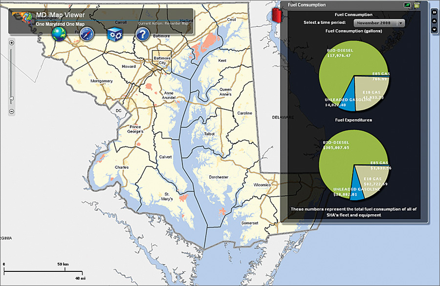
"The overall benefit, for staff and the public, is that StateStat makes government work and holds people accountable," says Beth Blauer, director of StateStat. "And a strong awareness of evolving business practices happens in the process so we are well versed in the business of a given agency. Since we know where their deficits and strengths are, we can quickly and adeptly reallocate resources, redefine missions, and adjust strategies and tactics to make the government work as efficiently as possible." The 14 StateStat participating agencies are the Maryland State Police and the Departments of Agriculture; Business and Economic Development; Environment; General Services; Health and Mental Hygiene; Housing and Community Development; Human Resources; Juvenile Services; Labor, Licensing, and Regulation; Natural Resources (DNR); Planning; Public Safety and Correctional Services; and Transportation (DOT). Before the meetings, agencies must update their data and deliver it to the governor's office. At each meeting, the governor's staff addresses particular aspects of the data based on their concerns or questions. The data and maps support conversations that range from operational expenses, such as overtime and fleet costs, to agency-specific questions. In the public safety sector, questions might include, What is the average length of juvenile stay in a detention center? How many facilities are serving youth in a community? How quickly are we turning around warrants? How are we supporting public safety initiatives? Turning to labor, questions arise such as, How are we addressing unemployment? How well are we connecting people with jobs? Are we connecting enough people with apprenticeships? "The data drives the entire discussion, and the discussion is framed by the maps, charts, and graphs, which get projected throughout the meeting," Blauer explains. Then the data, along with some of the maps, charts, and graphs, is posted on the StateStat Web site for the public. A recovery section has recently been added to the site with an ArcGIS Server software-based map to show how money from the American Recovery and Reinvestment Act will be spent. The data is accessible from the StateStat site and uses the MD iMap basemap (www.statestat.maryland.gov/). Currently, highway infrastructure, mass transit, and education data is available. Soon, the StateStat home page will feature an interactive map that will allow visitors to access more StateStat data and statistics. BayStat and GreenPrintAfter StateStat, staff in the governor's office saw a need for BayStat (www.baystat.maryland.gov), an accountability program that allows stakeholders and the public to assess information about Chesapeake Bay restoration projects. The monthly meeting includes representatives from the Departments of Agriculture, Environment, Natural Resources, and Planning, as well as scientists from the University of Maryland. Discussions at BayStat meetings include topics such as targeting property that can be purchased to support Program Open Space and deploying oyster cages in the bay for improved water filtration. Project Open Space is a long-running DNR initiative aimed at planning, acquiring, and/or developing recreational land or open spaces in Maryland. This land-based effort affects the health of the bay by mitigating factors such as runoff. GreenPrint (www.greenprint.maryland.gov) was a natural next step in measuring performance related to land conservation and sustainable growth. It is a planning tool designed to help government staff, conservation organizations, and individual citizens make good decisions about these issues. The goal is to protect targeted ecological areas, lands, and watersheds of high ecological value that DNR has identified as conservation priorities. GreenPrint is the first of the state's performance accountability applications that is available through MD iMap. Via MD iMap, visitors can see statistics such as those for land conservation in and out of targeted ecological areas by county and statewide. GreenPrint was developed with ArcGIS Server and provides layers of information, including protected and unprotected targeted ecological areas, tributary strategy basins, and the agricultural land preservation foundation. GreenPrint grew out of the BayStat initiative, and the two are closely tied. GreenPrint and BayStat meetings are held simultaneously, and the GreenPrint map serves as the framework for discussions about both programs. One Maryland, One MapMD iMap embodies O'Malley's vision of one Maryland, one map. It is the portal into the state's enterprise GIS, and it provides seamless, geocoded statewide centerlines and six-inch imagery. On the MD iMap home page, visitors can access statistics via the map on parcels, priority conservation areas, Program Open Space, protected lands, protected and unprotected targeted ecological areas, protected lands outside targeted ecological areas, the Rural Legacy Program, and highway beautification. Visitors can also launch the viewer from the main MD iMap page to access more data. The MD iMap Viewer houses information such as fuel consumption of all the State Highway Administration's fleets and equipment—pie charts break out biodiesel, petrodiesel, E10 gas, and unleaded gas consumption. Another link in the viewer's toolbox brings up storm water management data by county or statewide. The StateStat team has begun using MD iMap during their meetings. "StateStat meetings encourage us to continuously improve our work," says Gregory Slater, director of planning for the DOT's State Highway Administration. "Using GIS as the foundation not only enhances accountability but also allows us to share our successes with the public and helps us realize the direction we need to take moving forward." To further support state and local government staff in Maryland, a secure agency login on the MD iMap home page connects them to Maryland GIS Online, which is built with ArcGIS Online. On that site, staff can download data and Web services from other government entities in the state. This functionality will significantly enhance data sharing and coordination among state agencies and local governments. As MD iMap grows and local governments upload more data and services to the portal, it will become an indispensable tool for government staff and citizens throughout the state. It will be an essential place for agencies and governments to collaborate and coordinate efforts. It will also continue to support transparency and accountability and enhance the public's knowledge of how well government is operating and serving their needs. More InformationFor more information, contact Beth Blauer, director of StateStat (e-mail: bblauer@gov.state.md.us). |