Spring 2009
Spring 2009 |
|||||||
|
|
|||||||
Qatar's GIS Turns Twenty |
|||||||
Highlights
In 1989, the State of Qatar, a small nation on the Arabian Gulf, conducted a government-wide user needs assessment to determine which areas of government would benefit the most from the implementation of GIS.
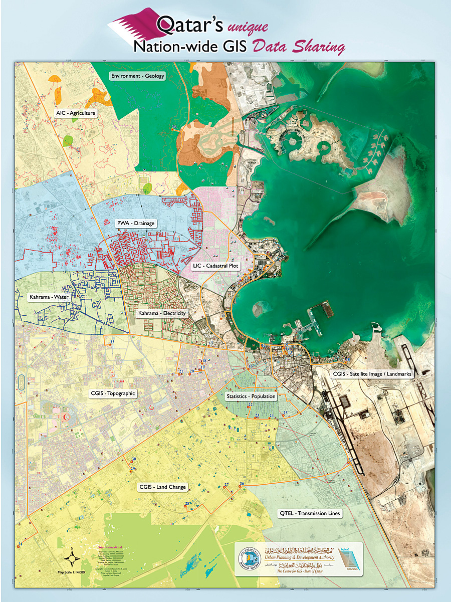
The results of the assessment indicated that the potential use for GIS throughout the government was enormous. In addition, the government subsequently issued three key recommendations. First, a high-level National GIS Steering Committee should be established to set standards and oversee the implementation and development of GIS in Qatar. Next, a digital basemap should be created for the entire country. Finally, a comprehensive fully integrated nationwide GIS should be implemented. Acting on these recommendations, the government established both the National GIS Steering Committee and the Centre for GIS (CGIS). The role of CGIS is to implement GIS in Qatar in an organized and systematic fashion and impartially serve the GIS requirements of all government agencies. One of the initial tasks of CGIS was to develop a high-resolution digital topographic database, which would provide a consistent framework for a wide range of GIS users and their applications. Today, more than 40 government agencies in Qatar are using GIS in their day-to-day activities. Because the same GIS standards are used throughout the country, the data and resulting applications of all government agencies are compatible, providing a nationwide GIS. In addition, the agencies are connected through GISnet, a high-speed network that allows the rapid transfer of data. Dozens of GIS applications have been developed that benefit the country's government agencies, private businesses, and residents. Qatar is currently experiencing an expanding economy and massive infrastructure development. Because of the previously established standards, those companies and agencies in need of GIS data can easily access and share the data they need, when they need it. Mohamed Abd El-Wahab Hamouda, head of the Planning and Projects Division at CGIS, comments, "Data compatibility itself tends to encourage and sustain cooperation among agencies because the data is readily transferred and easy to use." With the technical assistance, training, and guidance from CGIS, most government agencies have implemented GIS-based solutions that take advantage of the wealth of data that has been created during the past 20 years. The Centre for GIS—Maintaining the Accuracy and Accessibility of the Digital DatabaseAs the agency responsible for maintaining and providing online access to Qatar's Digital Topographic Database, CGIS makes sure that the comprehensive database comprises highly accurate, topologically structured, topographic vector maps; high-resolution orthoimagery, satellite images, and oblique images; a high-precision digital elevation model; and, most recently, a 3D city model of urban areas with a high level of detail. Since the topographic vector database consists of a huge volume of information, the data needs to be of highest quality with respect to precision, accuracy, attribute information, etc. To maintain such a huge database, a systematic approach was needed to perform revision and quality control for all incoming data (vector and orthoimages) and surveyed data.
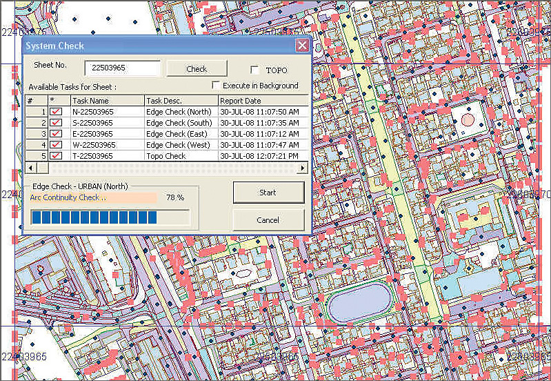
The revision and quality control system (RQCS) was developed to do quality control, editing, and updating of topographic data maintained by CGIS. Data is stored in an Oracle RDBMS with ArcSDE. The current version of RQCS is in ArcInfo 9.2, customized using ArcObjects and Visual Basic for Applications to facilitate the quality checking of data provided by external agencies or from the Survey Department and eventually to provide final quality controlled data for the end user. A number of steps have been taken to ensure the quality of the data. These can be broken down into three primary areas:
Through CGIS, the government encourages and facilitates spatial data sharing and interagency cooperation among Qatari organizations, enterprises, and government entities. CGIS maintains a rich and comprehensive national basemap and a robust framework for communication among groups in the country working with GIS. A few of the GIS initiatives that are supported by CGIS are described below. Qatar Telecommunications—Facilitating Network Expansion and MaintenancePrior to the implementation of GIS, Qatar Telecommunications', or Qtel's, only recourse during an emergency—for example, a break in service that affects 12 square miles of the city—was to analyze the landline network for the most likely location of the break. This necessitated examining hundreds of paper drawings showing the network for the area. The drawings were to scale (tied to geography), so devices were crowded together and became almost indecipherable where the housing density was high. Furthermore, some of the drawings were out of date. This was the type of problem that confronted the engineers of the company that provides wireless and wireline voice communications, Internet, and cable television services. To improve the efficiency of its operations, over the past few years Qtel has been automating its facilities management, including its planning and engineering operations. The company had already acquired basemaps of the entire country and maps of many of the key components of the infrastructure from CGIS. It was also using Telcordia Network Engineer (NE), an ArcGIS software-based product (from Telecordia, an Esri Business Partner, Piscataway, New Jersey), to manage the data. ArcGIS Schematics is now implemented because it allows direct access to underlying, native GIS data sources, eliminating the need to maintain libraries of individual schematic drawings and consolidating data edits to a single source. Some of the schematics the software generates, such as straight-line duct diagrams, are completely divorced from geography, allowing the network to expand and show feature connectivity clearly where features would otherwise be too crowded to distinguish. Other schematics are geoschematic in nature and allow network trace results to be viewed over the underlying basemap, so breaks in connectivity can be quickly identified and understood. Still other schematics can be generated by querying on attributes (e.g., "Display all copper lines laid in 1975 or earlier"). Common to all of these diagrams is the direct derivation of connectivity from NE geodatabase geometric networks—the structure/span network for elements like joint boxes, conduit, and ducts—and the telecommunications network for the telecommunications equipment features. The consolidation of source data in a single repository, the GIS database, offers Qtel a compelling advantage over traditional systems. The engineering effort is a fixed overhead activity that ends with the alteration of the database, and the ability to derive schematic products directly from the database means that the schematic update lag time is essentially eliminated, as is the introduction of error during the subsequent update of the diagrams. Qtel had also performed some customization on ArcGIS Schematics according to the following three categories: work order system integration, custom layout algorithms, and re-creation and automation of standardized Qtel schematic diagram marginalia. Ministry of Environment—Overseeing Development and Environmental ImpactEnvironment Site Assessment and Management System (ESAMS) is an example of combining newer technologies that bring out the potential of GIS in developing applications to support decision making at the highest levels. ESAMS is a decision support system totally developed in ArcView. It is a system that helps evaluate and assess the environmental viability of a site for any kind of developmental activity. The basis of this evaluation is a site suitability index map that is derived by integrating at least 15 different layers that represent potential constraints, like hydrogeology, geology, urban development, vegetation, and fragile landforms, in environmental evaluation of a site. All data layers are accessed online through the GISnet maintained by CGIS. ESAMS is a fully functional analytic tool that gives a qualitative and quantitative assessment of any selected site.
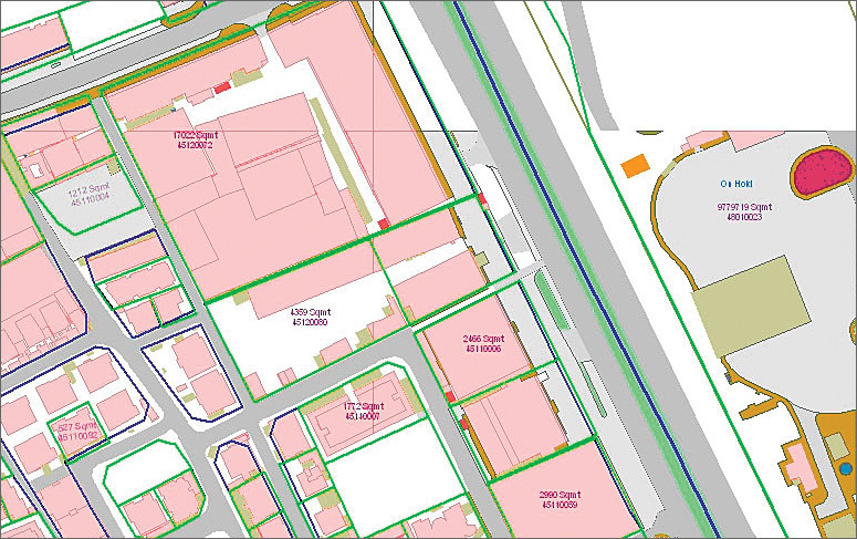
Given only the geographic coordinates of the site and the radius of influence that the proposed activity on the site might have, the system, besides showing the site location on a map, generates an automated report about whether the site lies on a suitable, moderately suitable, or unsuitable area. It includes information on nearest place and road and enumerates all the geographic features that are important in arriving at a decision on granting permission for the proposed activity. Another important feature of the system is that it gives qualitative and quantitative information on the groundwater in the vicinity of the selected site. The system is also customized to manage and monitor waste disposal sites (WDS) in Qatar wherein it generates a complete report on any selected site, along with its picture and composition. The system incorporates capabilities to edit the data as and when the WDS is cleared and add new sites automatically. Urban Planning & Development Authority—Developing the Land Information SystemThe land information system comprises a suite of applications used by many departments within the Urban Planning & Development Authority (UPDA). The scope of the project involves transitioning the existing coverage data model to the latest object-oriented Esri geodatabase model and redeveloping the existing old applications in Arc Macro Language (AML)/Avenue/ MapObjects. It also involves migrating the existing GIS database in the Land Information Center (LIC) to an optimized enterprise geodatabase model stored in an Oracle RDBMS. The system utilizes data coming from various sources of government through the GISnet maintained by CGIS. This includes policy plans and land-use data coming from the planning department, road flow lines coming from the public works authority, and topographic data and satellite imagery coming from CGIS. The system helped in the effective operations to create/update cadastral, policy plan, administrative boundaries, and design data. In addition to managing the workflow through the life cycle of a job, the system provides flexibility in changing data layers, creating layouts, populating editable fields, and using search methods and is made up of several modules. It also provides the ability to manage the workflow throughout the life cycle of a case in tandem with the job tracking system at LIC. The system plots various types of maps displaying policies, zoning regulations, permit approvals, other agency data, etc., with customized symbology and layouts. The country's achievements in GIS were recently recognized at the twenty-eighth annual Esri International User Conference when CGIS was honored with the Enterprise Application Award. Receiving the award was Hamouda, who commented, "I am honored to receive this award on behalf of the many individuals who have contributed to the success of Qatar's GIS." More InformationFor more information, contact Mohamed Hamouda, head of Planning and Projects Division, Centre for GIS—UPDA (tel.: 974-4955575, e-mail: mhamouda@gisqatar.org.qa). |