Spring 2009
Spring 2009 |
|||||||
|
|
|||||||
GIS Modeling Advances Studies of Late Holocene Hunter-Gatherers on the Columbia River Plateau
Reconstructing the Past: A GIS Settlement Pattern Analysis for Northwest North America |
|||||
|
by Kendra Carlisle and Robert Friedel Highlights
Archaeologists have determined that by 2,500 years BP (before present), a subsistence-settlement strategy called the winter village pattern was widely established among hunter-gatherers on the Columbia River Plateau in northwest North America. In this strategy, hunter-gatherers dispersed into smaller groups during spring through fall as they collected food resources in bulk quantities for winter consumption. During winter, they aggregated in larger groups at permanent villages situated in low-elevation riverine environments, where they subsisted on stored food supplies augmented by hunting and fishing.
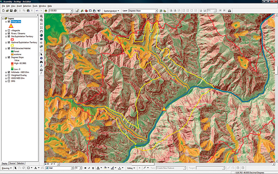
A topic that has not been adequately addressed by plateau archaeologists is how the subsistence-settlement strategies of late Holocene hunter-gatherers, which were sufficiently similar to allow identification of a regional pattern, varied at the local and subregional scale in relation to the structure of the environment and resource availability. One aspect of this question relates to the placement of settlements, such as the winter village. Researchers at Oregon State University in Corvallis, Oregon, took a GIS-based approach to studying the distribution of late Holocene winter village sites in the Lower Salmon River Canyon (LSRC) of Idaho. They developed a spatial modeling methodology and statistical analysis to explore how the economic needs of hunter-gatherers during the winter may have influenced their selection of the winter village location. Selecting a Central LocationThe researchers viewed the winter village as a central location from which foraging activities, specifically hunting, could take place to supplement winter food stores. Assuming that economically motivated hunters would wish to maximize their likelihood of hunting success while minimizing their energy expenditure, researchers hypothesized that winter villages may have been situated to allow relatively easy access to areas of high game productivity in the landscape (e.g., forest and forest/meadow ecotone). High-productivity habitat would have offered hunters an increased chance of success by virtue of greater numbers of game, serving to increase the likelihood of hunters encountering their targeted prey, and vegetation cover, which hunters could use to hide themselves while stalking their prey. It was assumed that a main source of prey would be native ungulates, specifically elk and deer, as this was typical of ethnographic hunter-gatherers of the Columbia River Plateau. To assess whether winter villages were intentionally positioned for optimal access to high-productivity ungulate habitat, the researchers selected ArcInfo with the ArcGIS Spatial Analyst extension on a desktop Pentium III to develop models for known village sites, showing the level of hunting payoff expected under a central-place foraging strategy. ArcInfo was an ideal platform for GIS analysis, as the researchers had used it for many years, and the user forums were an invaluable source of scripting and development support. The raster modeling capabilities of ArcGIS Spatial Analyst provided a versatile tool for cost-distance analysis, and the functionality of ArcInfo facilitated the necessary spatial data aggregation and manipulation. The AnalysisTo examine the quality of hunting grounds in the landscape surrounding known winter village sites, the researchers modeled the relative influence of game habitat productivity and topographic relief on hunting payoff-related movement within village site exploitation territories. The analysis involved three primary steps and was repeated for each village site in the sample population. For comparison, the procedure was also applied to nonvillage locations. To begin the analysis, the site exploitation territory was developed using an isotropic friction surface derived from a U.S. Geological Survey National Elevation Dataset 10-meter digital elevation model. With Raster Calculator in ArcGIS Spatial Analyst, this friction surface was input into a cost-distance formula with a known village site as the starting point. This produced a site exploitation territory extending the work equivalent of 10 kilometers from the site (assumed to be the maximum allowable distance traveled from a village during daily foraging activities). The second part of the analysis involved a weighted overlay grid developed in ModelBuilder. This grid was used to create a friction surface in which resistance is a function of potential hunting success dependent on habitat type and topographic relief, with greater success and lower relief offering the least resistance.
Finally, the weighted overlay cost surface and village site were put into a cost-distance formula in Raster Calculator to identify the optimal exploitation area within the site exploitation territory and calculate the total accumulative cost of traveling from the village site to the boundary of the site exploitation territory along least-cost (highest payoff) routes. In the optimal exploitation area, every cell is assigned a value representing the accumulative cost to reach that cell from the village along the least-cost path within the site exploitation territory. The optimal exploitation territory provides a visual representation of the direction and distance most likely to be traveled by hunters from the village during a single day. The total accumulative cost provides a relative index of the quality of ungulate habitat and steepness of terrain occurring along the least-cost trajectories within the daily foraging radius of a site. A Greater UnderstandingStatistical analysis indicated that the total accumulative cost values of village sites are significantly lower than those of nonvillage locations in sections of the LSRC where high-productivity habitat is heterogeneously distributed. Conversely, the total accumulative cost values for village sites and nonvillage locations are statistically comparable in areas where high-productivity habitat is essentially continuous across the landscape. The results of the statistical analysis suggest that in sections of the canyon where high-productivity ungulate habitat occurs in patches, winter villages were positioned to facilitate easy access to these areas in the landscape, providing a relatively greater chance of hunting success. Where high-productivity habitat is continuous across the landscape, there was no economic advantage for village placement with regard to access—one spot was effectively as optimal as another. This supports the hypothesis proposed by Oregon State University researchers. The GIS modeling described here contributes to a greater understanding of the late Holocene archaeological record in the LSRC of Idaho by identifying, in a testable manner, how late prehistoric hunter-gatherers may have selected the locations of their winter villages. The utility of the modeling methodology is much broader, however, as it is not restricted to the LSRC, a specific time period, or a particular resource. It is a tool that can be applied to archaeological sites of varying ages throughout the Columbia River Plateau. About the AuthorsKendra Carlisle received her M.A. in applied anthropology (archaeology/cultural resource management) from Oregon State University in June 2007. She is currently a staff archaeologist at a cultural resource management firm in Eugene, Oregon. Coinvestigator Robert Friedel received his M.S. in geography (remote sensing/GIS) from Oregon State University in June 2007. He is currently the GIS project manager at Tetra Tech EC, Inc., in Portland, Oregon. More InformationFor more information, contact Kendra Carlisle (e-mail: carlisle_kendra@hotmail.com) or Robert Friedel (e-mail: robert.friedel@tetratech.com). |