Spring 2009
Spring 2009 |
|||||||
|
|
|||||||
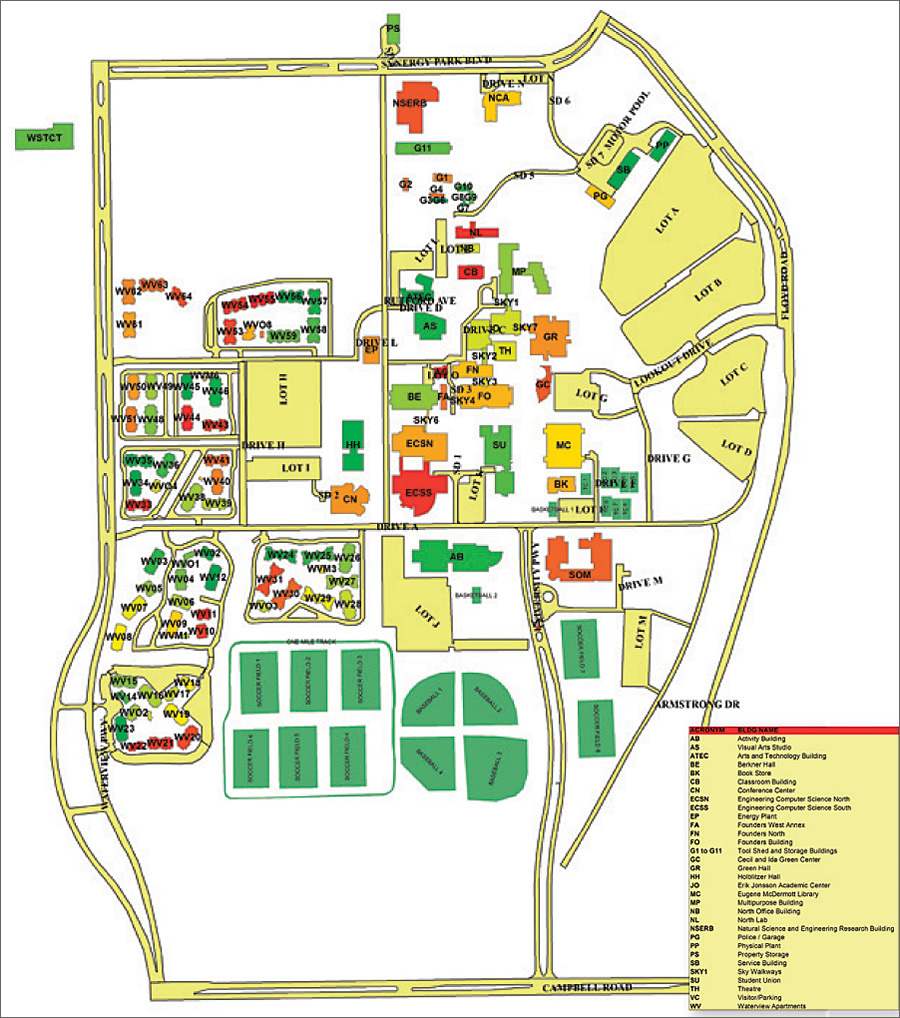
The Multifaceted Tool Is Used Throughout the University of Texas, Dallas (UTD)
University Enhances Its Logistical Tracking System with GIS |
|||||
|
By Nicolas A. Valcik, UTD Office of Strategic Planning and Analysis Highlights
In 2001, the University of Texas, Dallas (UTD), developed an in-house application to more effectively calculate the square footage of its campus structures. Named the Logistical Tracking System (LTS), this system was originally used as a facility inventory and accounting costs system that generated reports on federal research cost recovery and state facility inventory reports.
Once the system was brought online, its power and flexibility became apparent to other departments. The university police were interested in tying security devices, such as cameras, to LTS to locate personnel through their assigned office spaces. Environmental Health and Safety wanted to track hazardous materials shipments from delivery point to destination and accurately inventory and locate all hazardous materials on campus. Facilities Management wanted to be able to locate water and electrical lines, and Telecommunications wanted to be able to locate telephone and Internet cables on an accurate campus map. There was a general need for a new campus map—preferably color coded—to display on the university Web site and on campus kiosks. Furthermore, there were requests for the application to include a Web interface and to generate printable floor plans. The university's wish list kept growing. It was clear that these needs exceeded the existing capabilities programmed into LTS. Therefore, a new component had to be found—one that could enable the university to map out the campus infrastructure, track materials and personnel, and improve the dimensional calculations of the campus structures. The best option available was to create an enterprise geodatabase utilizing ArcSDE technology. The technology's capabilities—which enable robust multiuser editing, storage, and access of very large geospatial databases—and its synergy with LTS's tabular structure made the ArcSDE geodatabase a logical choice. [Note: At ArcGIS 9.2, ArcSDE stopped being sold as a stand-alone product. It is now included with both ArcGIS Desktop and ArcGIS Server.] The university's strategic planning office, which was heavily involved in the production of LTS, employed a developer who also held GIS certification and could work with existing blueprints and CAD drawings to input room measurements. UTD is also home to the Bruton Center, a research facility that focuses on the integration of geographic information systems, spatial analysis, and exploratory data analysis in the social sciences. Assistance from the faculty and students who worked there would be invaluable for integrating ArcSDE technology into LTS. Finally, UTD's geosciences department routinely uses remote sensing, geospatial information science, and GIS products to conduct research on geologic formations. To test their equipment, the geosciences faculty and students regularly scanned campus buildings, such as the Cecil and Ida Green Center. They also recorded GPS coordinates for many campus structures, which could be incorporated into LTS. The core of the GIS module was the creation of accurate floor plans that linked data from all other elements in LTS to produce final plans and reports. Three sources of dimensional data were CAD files, traditional blueprints, and manually recorded room measurements. If there was a discrepancy between the CAD files or the blueprints and the manually recorded information, the manual data took precedence. It was imperative that the dimensions be recorded as precisely as possible, particularly for those rooms that were shaped like pentagons or trapezoids or had rounded walls. Once room dimensions were recorded, a shapefile could be created and imported into LTS. The shapefile would derive additional attributes from the existing data tables. Thus, room numbers, personnel assignments, or any other information that might be desired could be linked to the shapefile to create accurately scaled and labeled floor plans. Since LTS tables are linked to shapefiles, the system will prevent the user from entering data on a nonexistent building or room and from attaching any type of information, such as hazardous materials or security infrastructure, to a location without data first being input into the system. The system is flexible enough to provide working maps of the campus infrastructure without incorporating the preliminary data into the permanent record. It also provides an audit trail of user modifications and can restrict access to certain modules based on the user's job responsibilities.
Expansion of LTSThe inclusion of an enterprise geodatabase in LTS enabled a significant expansion of the system. In 2006, information on hazardous materials was input into LTS to track laboratory inspections, record the National Fire Protection Standards 704 or "fire diamond" ratings for each laboratory, track the location of hazardous materials from the receiving point to their destination on campus, and identify the locations of waste containers through bar code identification markers. In addition, a jurisdictional map was constructed for the campus police so that they would know the boundary of their arrest authority. LTS was also able to generate that campus map that was so needed. The university relied on graduate students who were trained to become GIS operators. While the experience of working on this project was beneficial to the students' education, this arrangement meant that the staff had to devote more time to train and oversee the students' efforts. However, the benefits derived from adding an enterprise geodatabase to LTS greatly outweighed these challenges. Between fiscal year 2001 and fiscal year 2003, the upgraded LTS reaped a cost savings of $1.68 million for the university since the LTS application was developed in-house (Cost Savings Report FY 2001�2003 reported to State of Texas from UTD. Sizable cost savings still occurred with the LTS project after FY 2003). The Future of LTSAt present, LTS is used on a daily basis by numerous staff members at UTD. With more than 100 users, there are constant minor updates being performed to the application. LTS has recently been upgraded to .NET standard (January 2009), and programming is now going to evolve the reporting capabilities for queries against the system since .NET is more capable than the older .ASP configuration. About the AuthorDr. Nicolas A. Valcik is associate director for the Office of Strategic Planning and Analysis and clinical assistant professor for the Program of Public Affairs at the University of Texas, Dallas. He is the author of Regulating the Use of Biological Hazardous Materials in Universities: Complying with the New Federal Guidelines (2006, Mellen Press). As a result of this effort by Valcik, with Esequiel E. Barrera, UTD won the National Safety Council/Campus, Safety, Health and Environmental Management Association Award of Recognition (Unique or Innovative Category) in 2006. For More InformationFor more information, contact Dr. Nicolas Valcik, Office of Strategic Planning and Analysis, University of Texas, Dallas (e-mail: nvalcik@utdallas.edu, tel.: 972-883-6190). |