Spring 2009
Spring 2009 |
|||||||
|
|
|||||||
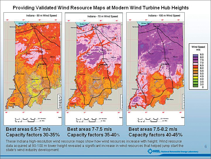
U.S. DOE's Renewable Energy Lab Maps Wind Resources with GIS |
|||
Highlights
During the 1970s, the United States experienced a significant energy crisis as oil consumption grew and supply fell. Soon after President Jimmy Carter came into office in 1977, he addressed the nation and said, "We must balance our demand for energy with our rapidly shrinking resources. By acting now, we can control our future instead of the future controlling us." His energy policy included maintaining healthy economic growth; protecting the environment; and developing the new, unconventional energy sources that the nation would rely on in the following century.
Several months later, Carter established the U.S. Department of Energy (DOE), and the Solar Energy Research Institute (SERI) was opened in Golden, Colorado. In September 1991, SERI was designated a DOE national laboratory, and its name was changed to the National Renewable Energy Laboratory (NREL). NREL is the primary laboratory for renewable energy and energy efficiency research and development in the United States. NREL works to advance many renewable resources, including solar, hydrogen and fuel cells, biomass, and geothermal, but wind is currently the most developed renewable energy market. Windmills appeared on the American landscape in the early 20th century and evolved into wind turbines that increasingly capture more energy and become more cost-effective. In 2006, President George W. Bush spoke about the nation's need for a more diversified energy portfolio and how wind energy might provide 20 percent of the nation's energy by 2030. In May 2008, DOE released a groundbreaking report, 20% Wind Energy by 2030: Increasing Wind Energy's Contribution to U.S. Electricity Supply. The report provides a road map to reaching this important goal, including identifying steps and challenges. As part of the research behind having 20 percent wind energy by 2030, NREL team members were tasked with updating wind resource maps. The updated maps were a critical component of the wind deployment model used to develop the 20 percent scenario. Using ArcGIS Desktop software (through a U.S. government license agreement), the NREL team can determine the most favorable locations for wind farms based on the cost of transmission, locations of load centers and wind resources, and the layout of the electrical grid. GIS-based modeling enables analysis of terrain, which significantly impacts the quality of wind at a particular site. The NREL team also examines economic development potential based on strong manufacturing centers and filters the data to exclude sites such as national parks and wilderness areas. "We use GIS for policy analysis and implementation analysis," says Marguerite Kelly, senior project manager at NREL. "We use it to help decision makers at all levels understand what their resource is." For utility developers, NREL creates forecasting models. "A utility wants to know not only what the average wind speed is at a location," Kelly adds, "but also what's going to happen in 10 minutes, and then in an hour—that's how they buy and sell electricity." The collaborative that produced the road map report includes the American Wind Energy Association, engineering consultants from Black and Veatch Corporation, DOE, Lawrence Berkeley National Laboratory, NREL, Sandia National Laboratories, and more than 50 energy organizations and corporations. Maps include details such as voltage of transmission lines and classes of wind speed and wind power. Forecasts include projected wind capacity by state in 2030 and the expansion of transmission lines that would be required. "The wind maps consistently amaze people," Kelly notes. "Often, the wind resource is much bigger than people expect, since a wind farm requires a strong steady breeze, not gusts." The primary audience for these maps is government decision makers who are thinking about how renewable energy can be used in their counties and states. The secondary audience is developers looking for renewable energy installations. As of September 2008, 35 states were generating wind power. Texas, California, Iowa, Minnesota, and Washington (respectively) made the Top 5 list of total wind power capacities. According to the American Wind Energy Association, as of December 3, 2008, U.S. wind capacity was just over 21 gigawatts (GW) (awea.org/projects). The United States must reach 305 GW by 2030 to meet the 20 percent goal. More InformationFor more information, contact Marguerite Kelly, senior project manager, NREL (e-mail: marguerite_kelly@nrel.gov). |