Spring 2009
Spring 2009 |
|||||||
|
|
|||||||
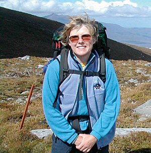
USGS' Leslie Armstrong—GIS Hero |
|||
|
Esri recognizes Leslie Armstrong as a GIS hero because she successfully puts GIS into action to make our world a better place. A predominant theme of Armstrong's 28-year professional career has been her desire to serve society and her fellow world citizens. With this idealism as the driver and technology as the vehicle, she has been able to steer a course that has accomplished much. Her work has provided opportunities to develop and complete projects in global and national mapping and earth sciences, long-term monitoring, earth observation remote sensing, conservation, military and civilian operational support services, training, and program development. Armstrong is deputy regional director of the Central Region, U.S. Geological Survey (USGS), and serves as the primary representative of the U.S. Cartographic Commission to the Pan American Institute of Geography and History. From 2004 to 2006, she served as the deputy staff director for the Federal Geographic Data Committee (FGDC), which is a leader in the development of standards and geospatial data infrastructures. These are the roadbeds for national and international geographic information highways. Armstrong has been a longtime supporter of applying geospatial technologies to geoscientific earth exploration to create products that aid decision makers and citizens alike. She sees investment in geospatial data management and data sharing as critical to our nation's well-being. "Our nation must invest in geospatial data management, the upkeep of that data, and integrating networks that can automate the revision of that information," says Armstrong. "Geospatial data networks and services are essential for us to address the critical concerns of our time, such as climate change and water availability. If we do not invest in the infrastructure and people to accommodate national-level geospatial programs, we are going to have a challenging time in the future. Furthermore, we need to continue to support other countries to develop and broaden those information networks." FGDC coordinates the development of standards and methods for sharing geospatial data on a national basis. One of its major goals is the development of the National Spatial Data Infrastructure (NSDI), a network that facilitates the accessibility and sharing of the nation's geographic information. FGDC has strong affiliations with the nation's government and has been instrumental in affecting international data sharing. In her tenure with FGDC, Armstrong led the completion of a U.S. framework of 13 core data standards. Certainly, FGDC's affinity for standardization of data sounds austere and bureaucratic, but its intent is quite altruistic and upheld as the mantra of many international organizations. Sharing geographic data improves people's lives and creates a better understanding for living in a sustainable world. Armstrong has a vision for the development of standards and spatial data infrastructure with the intent of bringing communities together and providing them with solid information for better decision making, locally and globally. Armstrong's work with FGDC opened the door for her to share her message with the United Nation's Regional Commission on Cartography for the Americas in New York. She also instills her vision through her work with the Pan American Institute of Geography and History, which coordinates and supports technical projects, outreach, and education throughout Latin America. This 80-year-old organization operates under the auspices of the Organization of American States and maintains commissions on cartography, geography, geophysics, and history.
In the early days of her career, Armstrong worked with the United States Department of Defense's Defense Mapping Agency (DMA) to create maps for Latin America. At the time, DMA's methods seemed light years ahead of those used by other mapping agencies. Still, user-friendly features in this cartographic software had yet to be developed. In those days, mapping software could be tedious and frustrating. Nevertheless, Armstrong used it to her advantage in her work with DMA's cartographic school in Panama. One of her projects included mapping the country with a focus on land use—especially aquaculture (shrimp farms) and the impacts on coastal mangrove forests. Her team produced a report showing the extent to which Panama's mangrove forests were declining due to construction of shrimp ponds, thus leading to potential destruction of shrimp habitat and nurseries. Working with the Agency of International Development, DMA and enthusiastic local groups formulated Armstrong's dream to make resource mapping and analysis technologies easier for people in other countries to use so that they could perform analysis that would help their nations' development. DMA was and continues to be a known leader in standards and the standardization process. The advantages of learning mapping standards, such as those for aeronautical charts and hydrographic and topographic mapping, sealed Armstrong's belief in the indisputable necessity of standardization. She explains, "DMA had it all spelled out. I knew exactly what I needed to do. These standards provided a guide for all our cartographers to output excellent products that bore the same quality and accuracy." In the 1990s, Armstrong was hired by the National Park Service (NPS) Information Systems Center in Denver, Colorado. Her strategic vision for NPS was to bring information technology to a complex and very decentralized organization—consisting of more than 389 park units—that lacked standards, training, and technical support. Following her arrival, the parks purchased licenses of ArcView, greatly expanding the GIS user base and development of park management applications. Working with a skilled team, she was able to transform NPS' GIS program into a national model for other federal agencies. Armstrong continued the Latin American connection by working with INPARQUES, Venezuela, on technology transfer and GIS program implementation. The Venezuelans acquired spatial data and GPS technology and use GIS for planning their national parks, including Canaima National Park, the home of Angel Falls, the world's highest waterfall. "In national parks, we used GIS to examine geographic patterns or trends of visitor and management activities, flora and fauna, earth features, and associated changes over time," says Armstrong. "It enabled us to improve planning, identify and protect habitat, and better understand fire behavior and management to name a few examples." As PC-based technology and training evolved, geographic data was coproduced in partnership with USGS for more than 200 parks, and the use of NPS' GIS skyrocketed. "Our goal was to help everyone use GIS themselves rather than our having to assign all GIS projects to a few park GIS specialists or support centers." She worked to bring together the data of all parks into a national GIS when ArcIMS was released. Today, standard geographic databases and tools enable park managers and the public to access and use park information. It is also a source for information that helps policy makers consider appropriate park protection strategies, boundary changes, or community growth in the beautiful areas near and around parks. The list of GIS projects that NPS GIS staff completed was impressive, so Armstrong decided to showcase these. She is coeditor of Mapping the Future of America's National Parks: Stewardship through GIS, published by Esri Press. This book addresses issues ranging from scientific management of fire, wildlife, invasive species, ecosystems, and wilderness to recreation and impacts to parks. In 2007, Armstrong was hired by USGS as the deputy regional director of the Central Region, an area that includes a 15-state swath in the middle of the United States between its Canadian and Mexican borders. More than 3,000 USGS employees and contractors work in the region, and it is home to 20 science centers. Armstrong's work now has a greater administrative emphasis than it once did, but she still has an apron hanging in the GIS kitchen. One of her many projects is working with the Department of the Interior (DOI) on its project Geospatial Modernization Blueprint, which is the first federal civil implementation of enterprise geospatial infrastructure and integration in several lines of business. The architecture and governance structure spans DOI's eight bureaus, making GIS information available for use in law enforcement, natural disaster response, and more. Armstrong is also working to ensure the long-term executive support and funds are on hand to make the DOI project a success. She explains, "It's not totally standardized yet, but we're getting there." Armstrong's career journey has routed her once again to the Southern Hemisphere. "This has been a really fun and interesting project," notes Armstrong. "Once again, I get to work at implementing the geospatial data infrastructure in Latin America and am using that type of technology, data, and expertise to increase the environmentally and socially conscious futures of those countries." Indeed, it is a dream realized. More InformationFor more information, contact Heidi Koontz, USGS (tel.: 303-202-4763, e-mail hkoontz@usgs.gov). |
 This article is part of an ongoing series honoring individuals who have made a difference in the world by applying a GIS solution to challenges or needs within conservation or their communities. Since these unique individuals have been selected for their innovations or special achievements in a particular field, the series is appropriately named GIS Heroes. Esri recognizes Leslie Armstrong as a GIS hero.