Colleges and Universities Participate in Community Maps Program
Esri's Community Maps Program is seeing growing participation from colleges and universities around the globe. Through this program, GIS users and organizations around the world are contributing their local geographic content to a community basemap published and hosted by Esri on the web. These community maps can be freely used by GIS users and provide the entire GIS community with cartographically rich and detailed, ready-to-use, high-quality basemaps for their GIS projects. (Please also see the Community Basemap Program article and the center poster in the Summer 2010 issue of ArcNews.)
When the program initially launched in spring 2010, local government authorities were the main parties interested in contributing basemap content. Cities, counties, states, and national mapping agencies that build GIS content were recruited to participate in workshops and training. As these clients were developing their content for the ArcGIS Online topographic basemap, many reached out to colleges and universities in their respective areas to gather large-scale map content for the campuses. Many of these colleges and universities were able to provide content for the online basemaps that also satisfied their own unique needs.
Universities and colleges are approaching the program from an academic perspective, as well as for campus facility management. Departments of urban and environmental planning, geography, earth sciences, and information technologies are finding that they have a stake in the Community Maps Program. The development of freely available online basemaps provides the foundation for class projects, showcasing real-world map production technologies that give students valuable, hands-on experience right in the classroom. Not only do they learn map production from start to finish, but their contribution is also published so that anyone can use it. Facility management departments on these campuses are able to integrate their map data into the surrounding city or county basemap to extend their basemap, as well as use the services from ArcGIS Online in their campus viewers. For departments, academics, and facilities, the contribution to the large-scale campus basemap is a win-win proposition: it supports campus GIS application needs and supplies the GIS community with trusted basemaps down to campus-scale details.
City of Carson, California, and Cal State, Dominguez Hills
When the City of Carson, California, joined the program, it saw a direct fit for the California State University, Dominguez Hills, campus in its map. Alex Rocco, the City of Carson GIS administrator, has a great relationship with the geography department at the Cal State Dominguez Hills campus and knew of the large-scale content the campus maintained. Immediately following the Esri Community Maps Program workshop Rocco attended in August 2010, he contacted GIS analyst and lecturer Michael Ferris at the university's Department of Earth Sciences to partner in the basemap development.
"Our campus is relatively small, and our facilities people maintain their data in a CAD format," says Ferris, "so most of the community map data had to be created from scratch. After discussing the Community Maps Program with Alex at the City of Carson, we decided that mapping the campus would make a great student project. Most of the students involved had little or no GIS experience at the beginning of this venture. The campus was divided into segments, and then each of the students was assigned a section. The students were given guidelines and base data for creating the necessary layers. Each of the sections was then merged into its respective feature class and imported into a geodatabase. The final step was to make sure all the unassigned or incomplete areas were filled in and adjusted, and then the final product was given to the City of Carson."
Rocco adds, "The campus sits within the city limits and makes a terrific AOI [area of interest] in our city basemap. The university data in the campus template is very eye-catching and great for drawing attention to the community basemap."
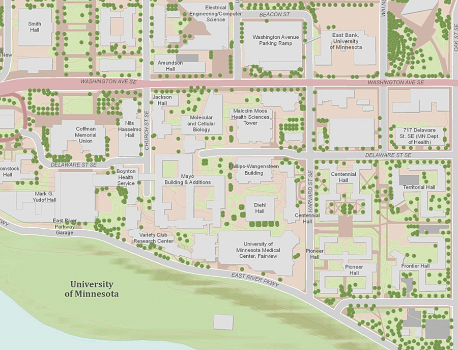
The Twin Cities campus provided by the University of Minnesota in Minneapolis, Minnesota.
University of Minnesota
The University of Minnesota (U of M), Twin Cities, with campus areas located along the Mississippi River in Minneapolis, Minnesota, supplied GIS data to the basemap developed by the City of Minneapolis. Daniel Sward of the University Services department maintains the GIS data for the Twin Cities campus. Sward was eager to share content for the GIS community but also has plans for using the ArcGIS Online map services within U of M campus web maps and mobile applications.
"I fully support the idea of sharing basemap data for the Community Maps Program," says Sward. "I feel the program has many advantages to GIS professionals and demonstrates one of the things I love about the GIS profession—that there is a real sense of community and an understanding that sharing resources can lead to better things for all."
University of North Carolina at Chapel Hill
The Town of Chapel Hill, North Carolina, and the Energy Services department of University of North Carolina (UNC) worked together to integrate data into a seamless basemap of the area. Esri's Charlotte, North Carolina, regional office worked with the two organizations to identify the map elements and create a plan for map production. Katherine O'Brien, the UNC Engineering and Information Services GIS coordinator, states, "The meeting with Esri was helpful because we drew attention to iconic features that were missing on other online maps. We felt very integrated into the process."
"While focusing on the quality of the data, we sometimes neglect the cartography," says O'Brien. "The community map approach to pulling together the definitive sources of the data was very appealing. We were nearing the end of a huge bond project, and demolished buildings are displayed and new buildings are missing on many popular online maps. It was refreshing to have someone come to us and ask for data. The Community Map project combines current and accurate data with good cartographic principles."
As Lisa Huggins, the GIS coordinator in UNC Energy Services, says, "I don't want any other backdrop for my services than our Community Map. That's a pretty map."
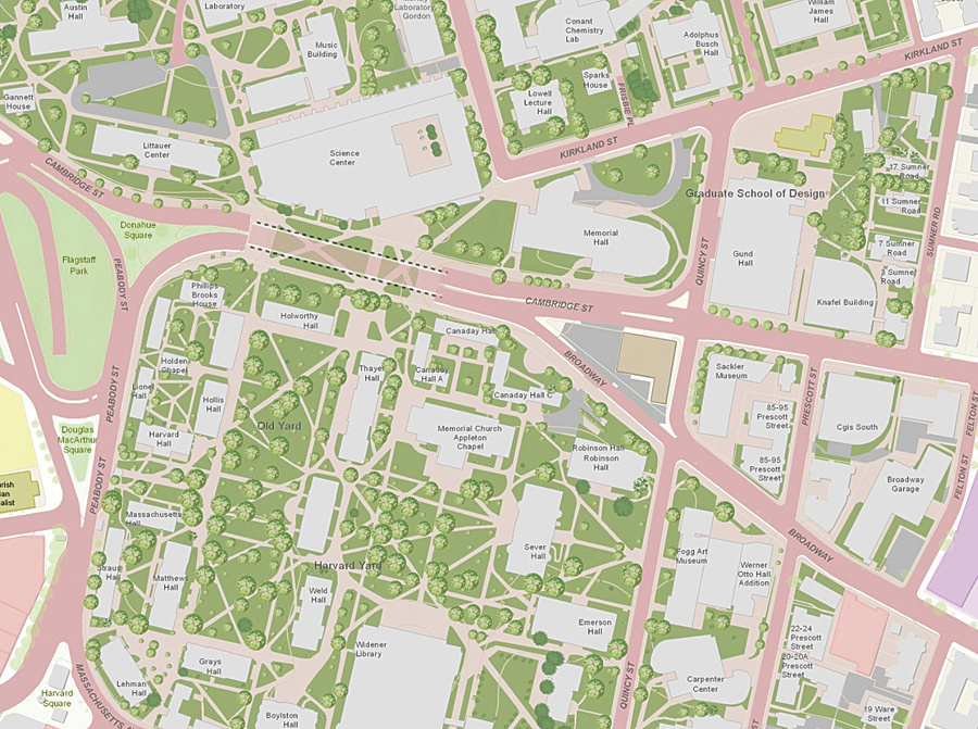
Large-scale basemap content contributed by Harvard Capital Planning of Harvard University in Cambridge, Massachusetts.
Harvard University
Harvard University in Cambridge, Massachusetts, has contributed large-scale topographic basemap content to the program with the mission to provide trusted data to departments within the university, as well as to outside data consumers. GIS manager Parvaneh Kossari and her team at the Harvard Capital Planning and Project Management department maintain the facility GIS data for the campus. She attended a brief seminar on the Community Maps Program at a regional Esri conference and contacted her Esri account manager to get involved. Kossari states that the department has a great deal of highly detailed data and was drawn to the look and feel of the cartography in the World Topographic template. Working with the City of Cambridge and Esri, Kossari contributed GIS data for the four largest scales of the World Topographic map service. This map was integrated with the neighboring City of Boston content, and a seamless urban topographic map was published on ArcGIS Online.
"Within the campus boundaries, we maintain the GIS basemap and operational data," says Kossari. "We already host services of our data, and in the past when a customer wanted basemaps extending into Cambridge and beyond, we would need to stitch data layers together. The Community Map allows us to be part of the global community and reach a broader audience with our content. Our operational map services will still be maintained on our system and serve our clients, but we recognize the audience is far larger with the topo map."
Upsurge in Collaboration
Michael Gould, director for higher education at Esri, adds, "These campus mapping initiatives are spreading across the USA and to other nations and are great examples of how volunteered geographic information [VGI] is created and curated in a controlled manner and not as an uncontrolled contribution of pieces that do not fit together. And we are very excited to see the upsurge in collaboration between campuses and their surrounding local governments." (See also "Volunteered Geographic Information Plays Critical Role in Crises.")
To learn more about the Esri Community Maps Program, visit the web page at esri.com/communitymaps.