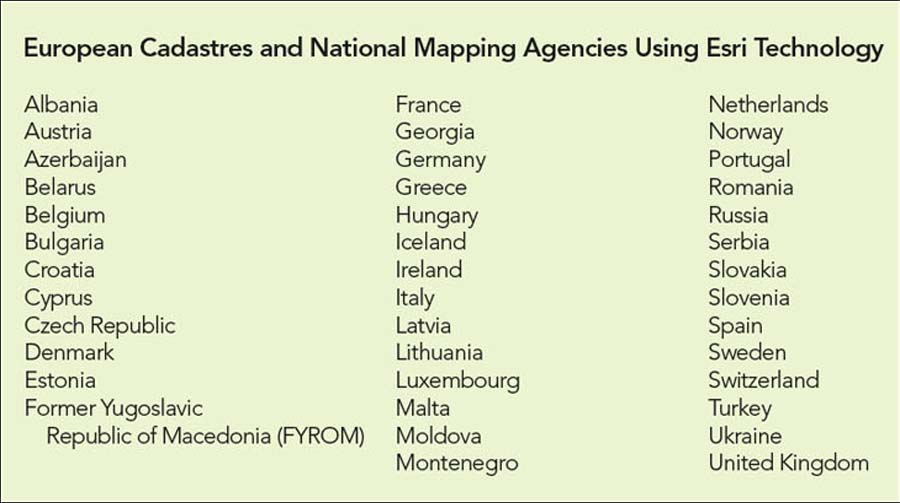
European Cadastres and National Mapping Agencies
Underpinning Land Management and Sustainable Development
Highlights
- Esri's GIS platform technology is used by many of Europe's NMCAs.
- Surveyors are able to submit cadastral data electronically.
- A new case handling system brings both text registers and cadastral index maps into an integrated GIS.
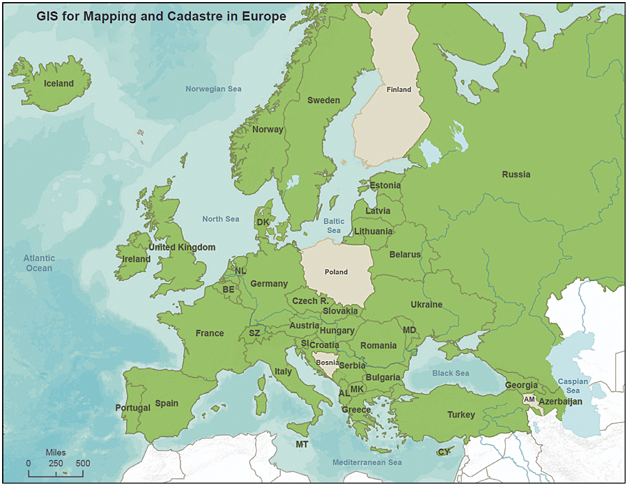
Green represents European cadastral and national mapping organizations using Esri technology.
A traditional cadastre is an official record of the dimensions and value of land parcels, used to record ownership and assist in calculating taxes. Today's cadastre, however, has evolved into a multipurpose land information system, as well as a foundational component of a nation's spatial data infrastructure (SDI). In most European countries, for example, the cadastre not only provides information about the ownership and value of land but may also include information on land use; legal restrictions; regulations concerning how land can be used; and the registration of important assets or infrastructure, such as utilities.
As the demands on Europe's national mapping and cadastral agencies (NMCAs) increase and their role continues to broaden, the fundamental importance and value of using GIS also grows. GIS technology allows NMCAs to not only run their core business national cadastre effectively and efficiently but also integrate it with other themes of information in the national SDI. In so doing, NMCAs can meet many other requirements for land and geographic information, particularly in the context of sustainable development and better land management.
Esri's GIS technology is the preferred platform of many of Europe's NMCAs. Cadastral and land registration systems vary across Europe, reflecting different historical backgrounds, cultures, legal frameworks, and organizational models. The following examples show how Esri is supporting successful cadastral systems across Europe.
Lithuania's Cadastre, Valuation, and Address Management System
Lithuania's State Enterprise Centre of Registers (SECR) is responsible for the nation's real property cadastre and register, address register, and register of legal entities. It also performs real estate valuation for taxation purposes. SECR uses Esri technology for computer-assisted mass appraisal and to update, manage, and distribute cadastral and real estate information for some 2 million land parcels, 700,000 buildings, and 500,000 engineering constructions and utilities.
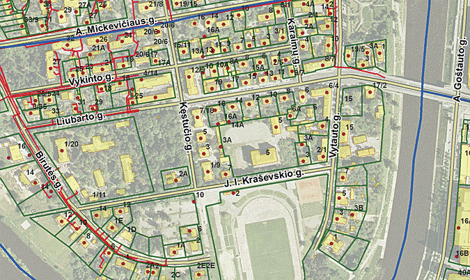
All of Lithuania's real estate records and cadastral data are integrated into one system. The digital cadastral map contains a wealth of information on administrative boundaries of counties, municipalities, cities, and settlements; centerlines of streets and roads; cadastre units and blocks, land parcel boundaries, and reference point coordinates; centroids for buildings and addresses; centerlines of engineering utilities; valuation zones of real properties; topography; and orthoimagery.
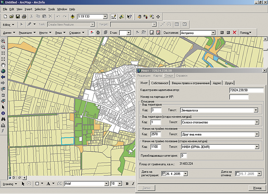
Prior to registration in the real property cadastre and register, SECR's 11 branch offices use the KADAGIS cadastre GIS application to remotely update the cadastral map. Using ArcGIS and the .NET Framework, KADAGIS has more than 50 user-friendly functions that efficiently control and speed up operations, such as data entry, editing, quality control, and updating of the central cadastral database. Updated cadastral parcel boundaries are entered from either coordinates or vectorization of scanned and georeferenced maps. Parcel areas and distances between boundary vertices are automatically checked. Additional attribute information is either entered manually, such as survey type and name of surveyor, or generated automatically, such as cadastral unit and block codes, municipality code, and parcel centroid coordinates. The system supports 700 checkouts for disconnected editing each day.
Providing access to the wealth of information managed by SECR is a critical and important task, as users—including private surveyors, banks, real estate agents, and citizens in general—demand more and better land information services. SECR has taken advantage of ArcGIS Server technology to support a number of applications, from browsing and viewing data to updating and integrating new data in its central registers.
A cadastral maps web application allows users to obtain information on real property cadastre and register data, property addresses, and valuation zones by searching by unique identifier, address, or geographic location. Private surveyors can also use the application to upload new cadastral (parcel) surveys in a variety of formats and compare them with existing registered parcels to ensure that parcel boundaries are correct.
SECR has also launched a lightweight web browser application that allows private surveyors and SECR staff to enter new data directly into the central cadastre database. This ArcGIS Server application eliminates the need for a desktop application to produce cadastral survey documentation. With just a web browser and a variety of editing tools on the web, a surveyor or SECR staff member is able to submit cadastral data electronically without paper cadastral files and manual data input. The system also includes digital signatures, which are already used by notaries who approve real estate deeds and other administrative documents.
Further operational efficiencies are being realized through the Address Register application, implemented using ArcGIS Server—Java, which allows municipalities to update address data, along with coordinates, directly to the central address database.
ArcGIS is also an important component of SECR's mass appraisal system, supporting taxation of real property. Because the system is GIS driven, it is possible to compute property values using a range of different characteristics, such as valuation zones, land use, area, year of construction, and building materials used. Tax formulas can be automatically applied and computed, and periodic revisions due to changes in law or tax fees can be easily accommodated. Through the application of GIS technology, SECR is able to largely automate the process, minimizing human intervention, saving time and costs, and ensuring repeatable and reliable results.
Sweden's Automated Cadastral Workflow
Lantm�teriet is responsible for Sweden's cadastral services, managing information for approximately 3.2 million properties. The Swedish cadastral system is well regarded worldwide for its effective land legislation and administration. Since the late 1990s, ArcGIS has been an important component of the overall system. It supports many aspects of land administration in Sweden, including surveying and mapping; real property formation; production of cadastral maps; public utilities mapping; property valuation and tax assessment; and national, regional, and local planning.
Lithuania's State Enterprise Centre of Registers relies on its ArcGIS software-based KADAGIS. The system features more than 50 user-friendly functions that speed up operations, quality control, and data entry into the cadastral database.
Through the implementation of ArcGIS software with other technologies, such as GPS, and new working methods, Lantm�teriet has been able to improve the efficiency of its cadastral procedures. These efficiency gains have been partly realized through better workflow and job management. Using GIS, the system ensures that legally defined procedures are followed in a unified production line. Users are taken through each stage of the process, from fieldwork and computation through data processing and documentation to the final storage of the data. Commands from a job are automatically stored to be available the next time the job is opened.
Recently, Lantm�teriet initiated a new project to deliver further efficiency through the implementation of a new case handling system that brings all property information together—both text registers and cadastral index maps—into an integrated GIS. The goal is to create an efficient cadastral procedure with which most customers can create their own cases (subdivisions) and automatically validate them against the property formation rules stored in a GIS database.
This new cadastral case handling system is part of a service-oriented architecture, whereby more general systems (e.g., financial and document systems) are connected. A central component of the system is the process engine, which has the ability to hold a cadastral case together throughout the process. The GIS solution is based on ArcGIS. The data in the GIS database comes from different sources and is validated among other controls with the topology rules built into the GIS database environment. In parallel with building up the new case handling system, an ongoing project at Lantm�teriet stores and delivers object-oriented land and property information in a central database. The new cadastral case handling system will, along with other registration systems, deliver changes to and retrieve them from the central database.
Once the new system is in full-scale production, it is anticipated that process times will be reduced by 20 to 30 percent and that maintenance costs for the more integrated system will be lower.
Belgium's National Cadastre Supports E-government
The national cadastral system of Belgium is maintained by the Patrimony Documentation Department inside Federal Public Service (FPS) Finance. It contains the records of the country's 9.4 million land parcels and 1 million registered strata or condominium units. Its cadastre was initiated more than 200 years ago during the French Revolution, when Belgium's land tax and the general cadastre procedures for governing land information were created.
In 2003, FPS Finance began implementing a new cadastral system called CadMAP. The purpose of CadMAP was to migrate from old analog cadastral map sheets to a digital cadastral map files system, supporting the update and management of the vector cadastre map files and improving the quality of the cadastral maps.
Bulgaria's CadMAP system contains data on 9.4 millin land parcels.
To meet these goals, ArcGIS was deployed in FPS Finance's central office, as well as 10 provincial cadastre offices and 300 local survey offices. FPS Finance set up a web software solution using ArcGIS to give users intranet access to digital cadastral maps inside the new centralized file management system.
With a customized GIS application at their fingertips, staff at local offices can now create and update local cadastral plans and submit them to the provincial offices. Concurrently, provincial offices can use a customized interface to make extensive modifications and quality enhancements to the plans submitted by local offices. Meanwhile, the central office uses its own customized interfaces for official cadastral extraction and cadastral sheet printing.
Attributes and layers in CadMAP include cadastral boundaries, parcel numbers, buildings, administrative boundaries, streets, rivers, bridges, parcel monuments, and municipality monuments. Managing a database with 39,000 cadastre map sheets, 200,000 changes per year, and several hundred users was a challenge, but CadMAP was successful, and FPS Finance migrated from the old paper management to the new digital system while updating and continually enhancing the quality of the cadastral data.
Following the success of CadMAP, FPS Finance launched the second phase of the project. This extension to CadMAP involved migration from the desktop file system of separate map sheets to an ArcGIS geodatabase with extended web solutions, providing improved access for existing intranet users and wider access over the Internet for external users, such as notaries, surveyors, and the citizens of Belgium.
Bulgaria's Unified Information System of the Cadastre and Property Register
In Bulgaria, the cadastre and property registers are the responsibility of two different organizations—the Agency of Geodesy, Cartography, and Cadastre and the Registers Agency. In some European countries, the two responsibilities are combined within a single agency, but in Bulgaria, a different organizational approach is taken. The two functions continue under different administrations, but through the implementation of an integrated information system for the cadastre and property registers, the two agencies are able to realize many of the benefits of having a unified agency.
In 2003, the Agency of Geodesy, Cartography, and Cadastre selected ArcGIS technology for its cadastral information system and implemented the solution in its central and 28 regional offices. The system supports all aspects of the cadastral workflow, from data input (from CAD files) through data management, visualization, and extraction of statutory documents in either hard or soft copy to ongoing maintenance of the cadastral data, including the full history of changes.
Subsequently, this agency initiated a joint project with the Registers Agency to implement a new integrated cadastre and property register system. The new system combines the cadastral parcel data with the ownership and legal information for each property within one database at the central level while allowing distributed updating from the local cadastre and registry offices.
This partnership approach has delivered a number of cost efficiencies and other more qualitative benefits. For example, all users now have access to the same land and property information, and all can be confident that they are working with the latest version of the data. The new integrated system is now of great importance to many GIS developments and users within Bulgaria and is laying the groundwork for much greater cooperation between public administration and private business.
For more information, contact Nick Land, Esri (e-mail: nland@esri.com).