
"Managing GIS"
A column from Members of the Urban and Regional Information Systems Association
GIS Management Scholars: Applying Practice to Praxis
By Dr. Michelle M. Thompson, Assistant Professor, Department of Planning & Urban Studies, University of New Orleans
As George Bernard Shaw stated in Maxims for Revolutionists, "He who can, does. He who cannot, teaches." This theory may hold some truth, but providing public participation geographic information systems (PPGIS) in an academic environment has similar, if not greater, challenges, since program implementation does not have the force of law or continuous financial support. My experience as a former licensed real estate appraiser and City of Ithaca, New York, GIS planning analyst strengthened my perspective as a former GIS manager at Cornell University and does so currently at the University of New Orleans. GIS technology allows planners to share both neighborhood and municipal data, but not typically within the same environment. This article focuses on how the WhoData (www.WhoData.org) Internet mapping service website moved the PPGIS concept into a New Orleans community data information system that works.
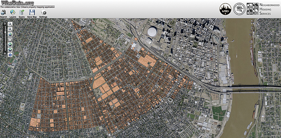
WhoData public participation geographic information systems (PPGIS) with Community Data.
Background
The University of New Orleans Department of Planning & Urban Studies (UNO-PLUS) is part of a city university where students apply planning theory to practice, or "praxis." The need for the planning community to work closely has never been greater than after Hurricanes Katrina and Rita in 2005. Community-based organizations, as citizen planners, significantly aided the recovery by identifying health and safety needs while prioritizing the cleanup of abandoned or blighted properties. Many local and out-of-state intermediaries, community-based organizations (CBOs), and university partners had good intentions, but the collection of neighborhood condition survey data was not synchronous, coordinated, or shared. In August 2010, the City of New Orleans Planning Commission approved the New Orleans master plan, Plan for the 21st Century: New Orleans 2030, which included a mandate to "establish a formal community participation program (CPP)" that may include a community data information system (CDIS) (City of New Orleans Master Plan, Section 15, 2010). WhoData was not created in response to the CPP but may support the CDIS since it is accessible to all.
Responding to Postdisaster PPGIS
In fall 2006, I served as the GIS team manager for the Association of Community Organizations for Reform Now (ACORN)/University Collaboration, which developed A People's Plan for Overcoming the Hurricane Katrina Blues for the ninth ward. This neighborhood plan was adopted by the City of New Orleans Planning Commission in spring 2007. Community-university-municipal PPGIS projects are typically customized for a single semester and serve a limited number of community clients. Since UNO-PLUS could not develop a GIS or manage the training needs of multiple organizations, creation of an Internet map service (IMS) was the next logical phase. In fall 2009, a PPGIS collaboration was formed with Neighborhood Housing Services of New Orleans (NHS), the Regional Planning Commission (RPC), and UNO-PLUS to further advance the www.WhoData.org website. By design, UNO-PLUS adopted the role of GIS manager of the IMS.
Outlined below are best practice standards that were used by this UNO-PLUS GIS scholar to manage the www.WhoData.org website from inception (summer 2009) to the present.
Project Scope/Planning: Identify and Evaluate Priority Public Policy Issues
The WhoData website includes neighborhood data and is modeled after many successful municipal data information systems. Dr. Joseph Ferreira, Jr., et al suggest that a "middle-out" approach combines the benefits of top-down and bottom-up initiatives while largely avoiding their respective pitfalls. ("The Future of Spatial Data Infrastructures: Capacity-Building for the Emergence of Municipal SDIs," 2007). New Orleans residents, investors, and municipal government departments need parcel-level data that identifies areas of blight, recovery, and renewal. However, until now, there hasn't been a unified approach to collecting the neighborhood condition survey data in a format that can be seamlessly integrated with city data.
Contracts and Services: Establish a Community-University-Municipal Project Scope and Service Contracts
Funding initially hampered server installation, but through the support of the University Computing Center, we were able to leverage the in-house computer support with high-end security, appropriate backup, and ongoing technical support. In fall 2009, GISCorps provided a generous gift of programming services using ArcGIS. Rafael Ferraro, GISCorps volunteer programmer, worked well beyond his call to duty and brought our dream to a reality on February 1, 2011. The collaborators were a web development team holding virtual project meetings for more than a year.
It was equally important to find a community partner willing to volunteer with IMS beta testing and share community survey data. We also needed a municipal partner that could provide regional data and suggest protocols that meet with Federal Geographic Data Committee National Spatial Data Infrastructure standards. David Lessinger, project manager and GIS professional from NHS, and Lynn Dupont, principal planner/GIS coordinator for RPC, filled these roles, respectively.
Team Building: Evaluate the Team Skill Sets and Develop a Plan to Increase CBO Capacity Through Training
NHS, RPC, and UNO-PLUS worked diligently to craft an outreach plan, establish survey data training, develop instrument standards, provide survey map services for in-field data collection, and identify neighborhoods that were in need of support. In spring 2010, organizations that conducted resident-led and volunteer neighborhood surveys discussed interorganization collaboration and data sharing mechanisms. While some of the organizations possessed staff, time, funding, and the technical ability to conduct surveys and implement a GIS, many could not.
As of January 2011, participating organizations include Associated Neighborhood Development, Broadmoor Improvement Association, Faubourg Lafayette Neighborhood Association, Gentilly Terrace & Gardens Improvement Association, Jericho Road Episcopal Housing Initiative, Lowernine.org, New Orleans Neighborhood Development Collaborative, NHS, Phoenix of New Orleans, Project Homecoming, RPC, and UNO-PLUS.
Project and Data Management: Identify Data Requirements, Municipal Services, and PPGIS Staff That Will Support the Project
Negotiating data sharing contracts with CBOs has not been difficult since the WhoData team remains transparent and willing to work with any and all stakeholders. We expect that site customization issues will arise as citizen feedback is obtained after the phase I site release in February 2011. On January 20, 2011, the parcel layer file was released to the public by Denice Ross, interim GIS manager for the City of New Orleans GIS Department. Access to this layer will now allow public and private GIS professionals to openly integrate parcel-level community survey and municipal data within a shared spatial environment.
Reflection
An academic GIS manager must create decision support systems and conduct business in a manner similar to a municipal GIS professional. The project management limitations are the same for those in any GIS environment: lack of time, money, and capacity. These can be minimized by identifying nonuniversity resources that share a similar vision and provide pro bono, nonproprietary services and implementing a project plan that has a longer trajectory than would be deemed profitable.
As the face of the new New Orleans shifts, so will the needs of the community. The www.WhoData.org website will make this change more transparent, support citizens, and assist our city officials with developing policies that reflect the shape of a city reborn.
About the Author
Michelle M. Thompson, PhD, has been an assistant professor in the Department of Planning & Urban Studies at the University of New Orleans since 2008. Thompson has provided real estate and market valuation services for over 20 years. She received her bachelor of arts degree from Syracuse University in policy studies, her master's degree in regional planning, and her doctor of philosophy degree from the Department of City & Regional Planning at Cornell University. She is currently the vice president of the Louisiana chapter of URISA and a member of GISCorps.
For more information, contact Dr. Michelle M. Thompson, Assistant Professor, Department of Planning & Urban Studies, University of New Orleans (tel.: 504-280-6593, e-mail: mmthomp1@uno.edu).