Making a New Road Atlas for Tourists and Travelers
Established in 1984, Mapping Specialists, Ltd., began as an offshoot of the cartography lab at the University of Wisconsin, Madison. Since that time, the private company's cartographers have provided quality maps for encyclopedias, street-mapping companies, and educational publishers for textbook maps and a wide array of materials for preschool- through college-level students. The company also assists many federal, state, and local governments in producing quality publications for their agencies. "Maps can sometimes look deceptively simple to create," says Adam Derringer, manager of GIS Services at Mapping Specialists. Cartographers and researchers both have a hand in the maps that are created both freehand and digitally. Each map means doing a large amount of research, whether the maps are created as illustrations to an author's text or used as a guide to find a location.
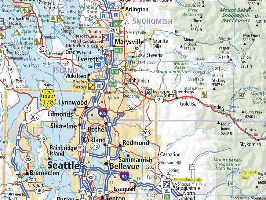
Esri's Maplex software was used to carefully place labels in areas with dense information, such as around Seattle in Washington State.
From Guides to the Ultimate Atlas
While Mapping Specialists has historically used Esri's GIS to create and manage map layers for its cartographic work, GIS didn't become a make-or-break prospect until the company began working with Rand McNally on the Thomas Brothers' road guides. This series of paperback, spiral-bound atlases features detailed street maps of many large metropolitan areas in the United States. With each book containing hundreds of pages, maintaining this data in a graphics-only package became prohibitive. If a feature changed on one page, ensuring that it was updated on all other referenced pages was an arduous task. That is where using GIS became imperative; with a geodatabase, features could be edited once and the change would be reflected on all pages where the particular feature was shown.
Having this experience allowed Derringer to take on another large project—a 224-page Ultimate Road Atlas designed for tourists and travelers as they explore the United States' vast network of highways. The atlas presents complete, updated road information and thousands of points of interest, such as a 24-page Traveler's Guide, including information and maps of national parks, as well as top picks for outdoor adventures, natural wonders, entertainment, culture, discovery, and unique examples of Americana—all highlighted on the atlas pages. Unique among American road atlases, the top of each map page describes several easy-to-find points of interest.
While the print market for maps has taken a hit since the dawn of GPS-laden mobile phones and inexpensive personal navigation devices, Derringer explains that the atlas market has held up well. Ultimate Road Atlas contains details such as a shaded relief map for the entire country; city inset maps; and a comprehensive, small-scale map of the Northeast Corridor of the United States. This gives a complete picture of roadways and tourist sites in the country. Each page features complete latitude and longitude, making the atlas the perfect complement to a personal navigation device. "You can't see all that information on a three-inch GPS screen," explains Derringer.
"We Couldn't Have Done This Project Without GIS"
ArcGIS with a Microsoft SQL Server database was used to store and edit data for the atlas. A team varying in size from 4 to 12 people created and edited more than 300 cartographic layers with the solution. Explains Derringer, "Cutting, editing, then reseaming hundreds of map pages would have been terrible—likely impossible—without ArcGIS."
Data collection and editing took 18 months, with the first year focusing on data collection. The data was largely created by Mapping Specialists staff using available data from Esri and state and local governments as reference. Place points are located on each map page by GPS coordinates down to the second. Since many features are maintained in multiple datasets for different mapping scales, using an ArcGIS geodatabase was necessary to ensure there were no conflicts in edited features and the versions used were the most accurate and up-to-date at all times. Working from the seamless geodatabase meant that all data was available and could be used for multiple pages. This cut down on both data errors and file size.
 A senior cartographer guided each group as the data was scrubbed and readied for placement on the map pages. Most editors had ArcGIS experience, but for those who didn't, training was straightforward and quick. "We spent more time on the rules for cartographic production than we did on how to run the software," says Derringer.
Label placement in Ultimate Road Atlas was the largest effort. Mapping Specialists created custom symbols for different feature classifications. Roads alone had six different classifications for how they were symbolized on the maps. Esri's Maplex software was employed for placement, but most text still needed to be touched by an editor. "In many cases, it was simply hitting the Maplex OK button," says Derringer, "but in others, the text needed to be moved. Maplex made what could have been a very time-consuming job into something that was manageable."
Mapping Specialists gained many efficiencies with ArcGIS on such a large project. "We used staff who hadn't done production work in more than 15 years," Derringer explains. "It took them only 45 minutes to get up to speed with the software. ArcGIS is a pretty effective tool for people, especially those who come from a graphics background."
Editors maintain they couldn't have completed the project without GIS to handle the many page spreads and features. Having a complete geodatabase of features will make new editions of the atlas an easier task to manage. Much of the unique symbology created can be licensed to or used by other agencies for map production, from small publishers to national mapping organizations in need of creating a national atlas.
For more information, contact Adam Derringer (tel.: 608-274-4004, e-mail: adamd@mappingspecialists.com). For more information on Esri's solutions for cartography, visit esri.com/cartography.
Related Podcast
Creating The Ultimate Road Atlas with ArcGIS
Adam Derringer, manager of GIS Services at Mapping Specialists, talks about using ArcGIS to design a 224-page road atlas for tourists and travelers on America's highways. Listen to the podcast. [11:00 | 10 MB]