Multinational Mapmaking in the Czech Republic
A Database-centric Approach to Mapping Distant Territories
Highlights
- Esri's Defense Solution produces high-quality military cartographic products quickly.
- Map portrayal and readability are improved with ArcGIS geoprocessing tools.
- ArcGIS projects serve as a place for map composition creation.
The Geographical Service (GeoS) of the Armed Forces of the Czech Republic has produced high-quality national maps for the country for decades. This experience has led the organization to offer its services to the Multinational Geospatial Co-Production Program (MGCP), an international program that brings together 28 participating countries from all over the world to assist in data production for countries where commercial satellite imagery is usually the only data source.
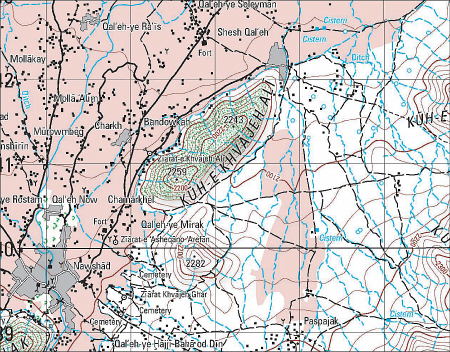
GeoS produces maps for the Multinational Geospatial Co-Production Program, like this one for the country of Afghanistan.
GeoS has been producing the maps, called MGCP Derived Graphics (MDG), since 2007. These maps resemble Topographic Line Maps at 1:50,000 scale (TLM50) and are used to support international humanitarian and peacekeeping operations in these countries.
A longtime user of Esri technology, the Military Geographic and Hydrometeorological Office (MGHO) that serves as the executive body of GeoS chose ArcGIS, including Esri Defense Mapping, to produce the MDG maps. GeoS was looking for a system that would provide a broad range of tools for various military geographic applications. Esri Defense Mapping is used by 25 of the 28 participating nations to help promote standardization of features and maps within the MGCP working group. This, coupled with the capabilities for building and maintaining digital databases and producing high-quality cartography, led the organization to choose Esri Defense Mapping for its military mapping. As a result, MGHO has built its own digital production system based on the ArcGIS platform for the MDG production workflow.
A Workflow for Producing Maps Quickly
One of the typical operational requirements coming from military and civilian data users is to quickly prepare the TLM50-like map for a distant territory. As most cartographers know, this task is quite complex. The source geospatial data must be obtained in the correct format and a map created according to the specifications, including properly applied symbology. Cartographic noise, such as overlapping text on the map, must be deleted, and surrounding elements need to be refined. Finally, the map needs to be published as either a printed or digital copy. All this must be finished and delivered in a specified time frame, which is usually short.
Using ArcGIS, GeoS has a workflow that resolves several key issues when publishing these maps in such a short time frame. Staff are able to do several important tasks with ease, including creating appropriate symbology sets and harmonizing them, providing administrative boundaries, and determining appropriate map composition and finishing.
Cartographic Tools Provide Sophisticated Symbology
The cartographic tools in ArcGIS help GeoS create the correct symbology on the generated map. Technically, two new attributes must be added inside each feature class with a cartographic representation definition: the rule and the override. In general, a rule is represented by a symbol and its behavior, while an override serves as a place to store exceptions to the rule. Appropriate symbology rules have been defined for each feature class inside the MGCP database, and each feature is represented by one rule.
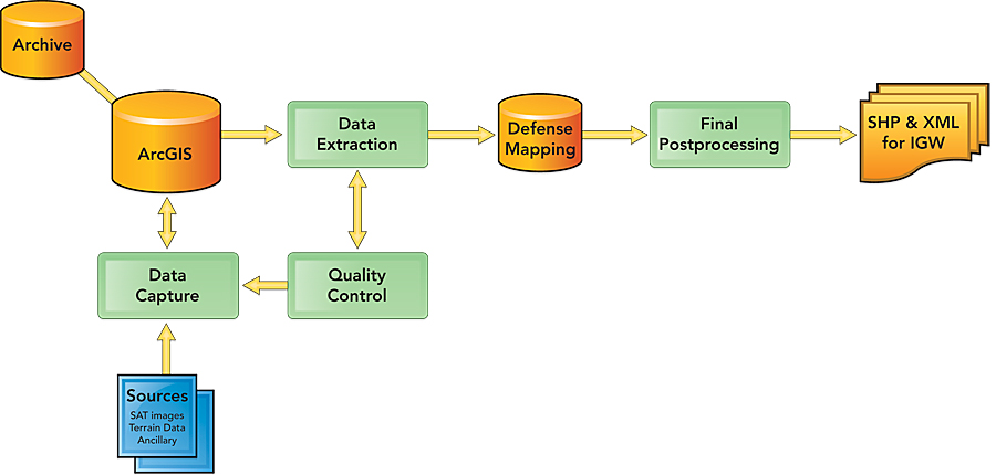
A simplified workflow for creating high-quality military cartographic products by GeoS.
Rule matching for each feature is based on properly defined attribute combinations. This database-driven approach to symbolization provides many advantages: Both the digital landscape model and the digital cartographic model can coexist in one dataset. Geometry edits of cartographic representations do not change the original feature geometry. Quick symbology matching based on attribute combinations is achieved through a user-defined Python script that has been compiled for converting the landscape model into the cartographic model. The out-of-the-box MGCP symbology supplied with Esri Defense Mapping enables quick and efficient cartographic production. Improved cartographic refinement tools, both automatic and semiautomatic, can be used, including rotation, visibility management, and shifting.
Since the MGCP program does not provide elevation data and delta features, other data sources must be exploited to fill gaps in the map content. User-defined tools for processing these sources have been established, such as an ArcGIS geoprocessing model for assembling and successfully applying spot height generation. Digital Terrain Elevation Data level 2 was implemented to create contour lines, as well as shaded relief. This helps improve terrain portrayal and map readability.
Esri software has been used successfully in two editions of MDG and will continue to be the technology of choice. Using the software to create MDG data and maps helps GeoS customers receive rapid map output of the highest quality.
For more information, contact Radek Wildmann (e-mail: radek.wildmann@vghur.army.cz); Vladimir Kotlar (e-mail: vladimir.kotlar@vghur.army.cz); Lubos Belka (e-mail: lubos.belka@vghur.army.cz); or Jan Soucek (e-mail: JSoucek@arcdata.cz), ARCDATA Praha, s.r.o., Esri's distributor in the Czech Republic.