NOAA Geoportal Speeds Data Discovery at National Climatic Data Center
Highlights
- The open source format of Esri Geoportal Server allows users to directly contribute features and fixes that support real-world work.
- NOAA uses the geographic data portal platform to share its own datasets and registered data from thousands of organizations.
- Standardized protocols, such as REST and CSW, speed discovery and provide direct access to metadata.
The National Climatic Data Center (NCDC) houses the world's largest collection of weather and climatic data. As the climate data steward of the National Oceanic and Atmospheric Administration (NOAA), NCDC has the federal government mission to describe the climate of the United States and report climatic trends and anomalies observed in the data. Because of the benefits derived from that mission, there is a large demand by earth scientists and users around the world to access data from many fields of study for research purposes. Recently, NCDC completed the first phase of integrating a system for organizing and sharing data resources more efficiently.
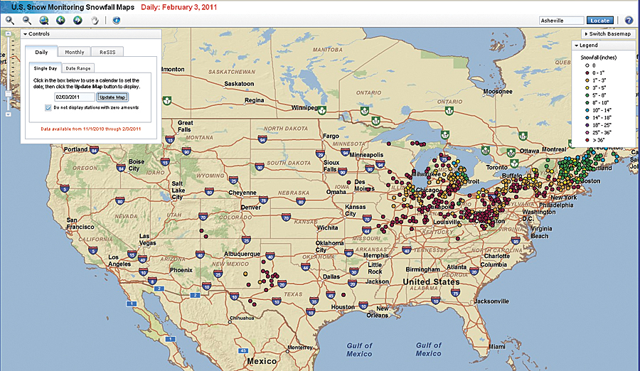
US Snow Monitoring Snowfall Maps present recent and historical snowfall analysis for the United States.
Efficient Discovery Platform
Managing data to keep it searchable, accessible, and shareable is an important practice of any research organization. The processes associated with managing and disseminating large volumes of data have the potential to slow a system and result in an unnecessarily high workload for system administrators. Supported by the right technology, however, these challenges can be overcome.
Recognizing that its technology will be used in distributed and heterogeneous environments, Esri supports the definition of a number of the Open Geospatial Consortium, Inc. (OGC), specifications and has implemented them in its ArcGIS family of products. Esri Geoportal Server (formerly known as the ArcGIS Server Geoportal extension) applies those standards to help organizations create and manage geoportals where data producers can register their geospatial web services, data files, and applications for discovery by consumers. In 2009, NCDC moved its datasets into ArcGIS Server and used the Geoportal extension to make them available through a geoportal called the NCDC Geodata Portal.
NCDC's decision to leverage Esri's geoportal technology was the result of much investigation and the maturation of Esri's geoportal software. In 2007, a NOAA GIS Committee working group received a funding allocation through the High Performance Computing and Communications Office to investigate innovative technology for organizing and sharing its data resources. As a result of this effort, NCDC determined that Esri's geoportal technology would support the creation of a site to serve and share data. At the time, Esri geoportal technology seemed promising, but it relied on older technology that made it a challenge for NCDC to install and configure. By 2009, NCDC had already planned to move to ArcGIS Server, and the center determined that the Geoportal extension had been enhanced to the point to meet its needs.
Protocols Simplify Search
Esri's geoportal technology gives organizations the capability to aggregate geospatial resources for improved discovery, use, and collaboration. It does that by using standards such as OGC's Catalog Service for the Web (CSW), which simplifies the cataloging and inventorying of metadata. Before implementation of CSW, data producers submitted their metadata to data clearinghouses, such as Geospatial One-Stop. However, since clearinghouses couldn't update metadata records as frequently as the owners of that metadata, information quickly went stale. CSW changed that by allowing datasets and metadata to be virtually centralized in data portals maintained by users. Using geoportal technology implemented with CSW gives users the ability to search both other geoportals from within the NCDC Geodata Portal interface and the NCDC geoportal from ArcGIS Desktop, ArcGIS Explorer, and Flex-based mapping applications.
REST supports geoportal users in crafting custom searches for resources and calling those searches from other applications. For example, the NOAA site calls search results from the NCDC geoportal using REST-formatted URLs. REST and CSW are powerful communication and integration points for organizations like NCDC that have decentralized offices, data repositories, and user bases.
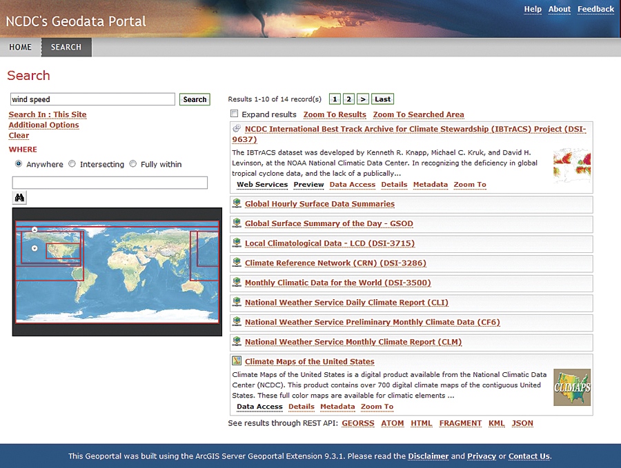
NCDC's Geodata Portal provides metadata search results for popular climatic data products.
Many data-producing organizations use Esri geoportal technology to improve knowledge sharing, reduce duplication of effort, and direct people toward the best available data. Recently, the ArcGIS Server Geoportal extension was redeployed as Esri Geoportal Server and released as an open source project on SourceForge. Being open source, Geoportal Server will continue to evolve as users have more direct input in how to integrate cutting-edge technologies to better catalog, discover, and use geospatial data.
For more information, contact Rich Baldwin, GIS Projects lead (e-mail: Rich.Baldwin@noaa.gov).
Related Podcast
Port of Los Angeles Unifies Operations with Data Portal
Daniel Elroi, president of North South GIS, discusses the challenges and successes of implementing a GIS data portal at the Port of Los Angeles. Listen to the podcast. [10:00 | 9 MB]