Planning for a Polder in the Netherlands
Geodesign Project Integrates Water Management and Land-Use Planning
Highlights
- Land tracts surrounded by dikes (polders) were modeled with quantitative and qualitative trade-offs regarding water and land-use plans.
- With ArcGIS and CommunityViz design tools, land-use stakeholders work together on new plans, sketching ideas and receiving fast feedback.
- The project combined GIS mapping and scenario planning tools, which allowed the team to integrate expert knowledge into the decision process.
The Dutch are familiar with polders—low tracts of land typically enclosed by dikes—and their characteristic hydrologic and land-use challenges. The Bodegraven polder, located in the province of South Holland, is a low-lying peat meadow area of some 4,672 hectares (11,545 acres) in the Netherlands, where water tables are controlled to enable multiple land uses. While Bodegraven has been predominantly used for commercial dairy farming, it is also important for its high natural, cultural, and historical value.
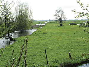
The project study area is the Bodegraven polder, located in the Province of South Holland in the Netherlands (photo copyright Frank Stroeken from Terra Incognita).
Bodegraven is currently facing a number of problems that will affect the sustainability of its land uses: ground subsidence, preservation of the peat meadow landscape, inefficient water management, poor water quality, and the changing economics of dairy farming. Multiple stakeholders are thus involved, including the local water board, the City of Bodegraven, the Province of South Holland, farmers' organizations, and nature conservation organizations, as well as individual farmers, residents, and recreational visitors. Consequently, the provincial authorities have started a planning process to review and adjust both water management practices and land uses in the area. The Spatial Analysis and Decision Support Department of the Institute of Environmental Studies worked with stakeholders to develop and test participatory tools to support integrated land-use planning and water management within this region despite conflicting objectives.
The project team structured the planning process for Bodegraven into a series of three interconnected stakeholder workshops: design, analysis, and negotiation. In the design workshop, the team defined three reference plan alternatives, stakeholder objectives, and evaluation criteria. For scenario planning, the team used ArcGIS and CommunityViz, an ArcGIS extension, extensively during the analysis and negotiation workshops to visualize maps and scenarios. The team was already familiar with Esri software, as it uses it for most of its mapping and cartography work, and it chose to continue using the software for this project. Additionally, the team chose to work with CommunityViz because of its compatibility with ArcGIS and its versatility for application to a wide range of planning studies. The software's calculation speed also made it suitable to support geodesign and conversations around an interactive device, such as a touch-enabled interface, or touch table. The combined solutions allowed "spatial discussions to be clearer and better supported," comments Aletta van der Zijden, regional coordinator of landscape management in South Holland.
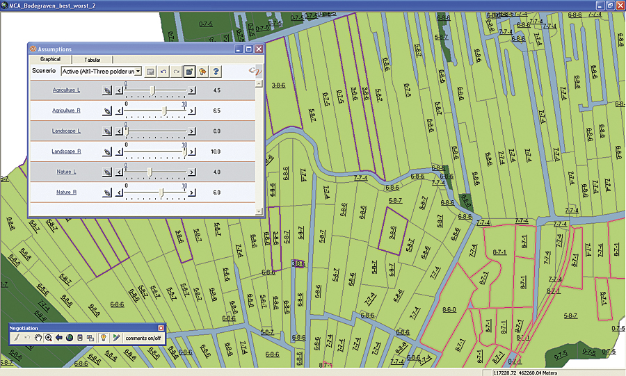
Quantitative trade-offs of the project were identified by selecting polygons that would profit from a land-use swap based on their actual MCA value.
The touch table supported stakeholder participation in the workshops and acted as the main map interface for the geodesign software. A separate screen was also set up to view additional information, such as charts and tables. In the analysis workshop, the project team used ArcGIS to present maps with thematic information about the region to increase the understanding of participants, who included both experts and stakeholders with varying backgrounds. Next, the project team used Scenario 360, a component of CommunityViz, to create scenarios. Each scenario consisted of a polygon-based suitability map in which the weights of each criterion were set according to participants' values. Participants could change the weights interactively using the touch table to adjust assumption settings in the software.
As the weights were changed, the results were dynamically updated and presented both on the touch table as a map and on the separate screen as a bar chart showing aggregated scores for various criteria and objectives the participants had established. A set of weights and the corresponding set of value maps constituted the main product of this phase. Ton Verdoorn, a project manager from the Province of South Holland, remarks that the combination of GIS and planning tools made it "possible to quickly and clearly see both spatial and numerical consequences of changing variables on the map."
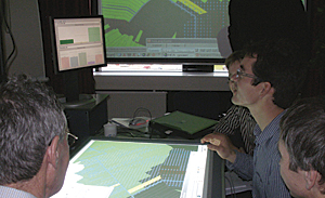
A large touch table acted as the main map interface for the project. It facilitated stakeholder participation in the three project workshops.
The negotiation workshop supported the process of collectively changing the current land-use pattern of the polder into a new, negotiated plan. Participants were the institutional stakeholders: the water board, the City of Bodegraven, the Province of South Holland, and nature conservation organizations. To support negotiation, the project team used multicriteria methods to show trade-offs among stakeholder objectives. Stakeholders used Scenario 360 to adjust two kinds of trade-offs: qualitative and quantitative. Qualitative trade-offs were identified by selecting polygons that were "very suitable" or "very unsuitable" for each potential land-use type based on their summed area and ranked multicriteria analysis (MCA) value.
Quantitative trade-offs were identified by selecting polygons that would profit from a land-use swap based on their actual MCA value. The next step was to change the plan. Stakeholders used their hands with the software's sketch tools to change land-use patterns on the touch table as they discussed the changes. A land-use palette allowed participants to assign new land uses to target parcels. As soon as the participants agreed on changes, MCA results were updated and displayed as bar charts on a separate screen in real time.
This project ran for four years, from 2006 to 2010, and ended with a positive result that satisfied all the project stakeholders. The combined use of GIS mapping and scenario planning tools allowed the team to integrate expert knowledge with stakeholder perspectives into the decision process of Bodegraven.
For more information, contact Gustavo Arciniegas, PhD, consultant in GIS and planning. Visit the Institute for Environmental Studies website. Visit the Province of South Holland website. Learn more about CommunityViz and the DiamondTouch table.