Sea Predators Guide Scientists to Vital Ecosystems
Highlights
- ArcGIS was used to process the remote-sensing georeferenced data, shapefiles, and raster grids.
- WCS uses GIS to create a composite view of Patagonian Sea ecosystems.
- Researchers used GIS to process the remote-sensing tracking data and generate distribution density maps.
The presence of top predators is an indicator of a food chain that supports them and the ecosystem necessary for that food chain to thrive. The southern seas and coastlines of ![]() Argentina and Chile, known as the Patagonian Shelf, are a habitat to albatross, colonies of Magellanic penguins, and pods of right whales. The hints provided by these and others predators, along with scientific analysis and GIS depictions, help nongovernmental organizations (NGOs) better understand and conserve the ecosystems of these waters.
Argentina and Chile, known as the Patagonian Shelf, are a habitat to albatross, colonies of Magellanic penguins, and pods of right whales. The hints provided by these and others predators, along with scientific analysis and GIS depictions, help nongovernmental organizations (NGOs) better understand and conserve the ecosystems of these waters.
Wildlife Conservation Society (WCS) and Birdlife International have collaborated to create Atlas of the Patagonian Sea, which contains maps showing key migratory corridors for top predators such as albatross, petrels, penguins, fur seals, sea lions, and the southern elephant seal. More than 25 scientists from other research institutions and conservation organizations contribute their experience and data to the project. Esri and Aeroterra S.A. (Esri's software distributor in Argentina) donated GIS software and support for visualizing and analyzing data.
The use of the Patagonian Sea (off the coast of South America) by 16 species of top predators is mapped.
In an effort to conserve the biodiversity of the Patagonian Sea, WCS launched its Sea and Sky project. "This unprecedented atlas was essentially written by the wildlife that lives in the Patagonian Sea," says Dr. Claudio Campagna, who runs the WCS Sea and Sky initiative. "It helps fill in many gaps of knowledge and should serve as a blueprint for further conservation efforts in the region."
Researchers used satellite transmitters, geolocators, and recorders for GPS to track predators during foraging trips. They then used ArcGIS to process the remote-sensing georeferenced data, shapefiles, and raster grids. In addition, they used ArcGIS Spatial Analyst to analyze spatial relationships and build spatial models, ArcGIS 3D Analyst to view a surface from multiple points and drape data over a surface, and ArcGIS Geostatistical Analyst to study multiple phenomena.
WCS Sea and Sky's GIS database contains more than 283,600 geographic positions (localizations) of 16 species of seabirds and marine mammals. The majority of the data was obtained by satellite transmitters. Fifty percent of the localizations are in the Patagonian Sea and correspond to approximately 1,300 migratory or foraging trips.
WCS used GIS to answer guiding questions, such as
- Where are the areas of the southwest Atlantic with the highest concentration of foraging top predators?
- Based on the location and timing of the foraging phase of a sea animal's annual cycle, how can we improve the protection of that species?
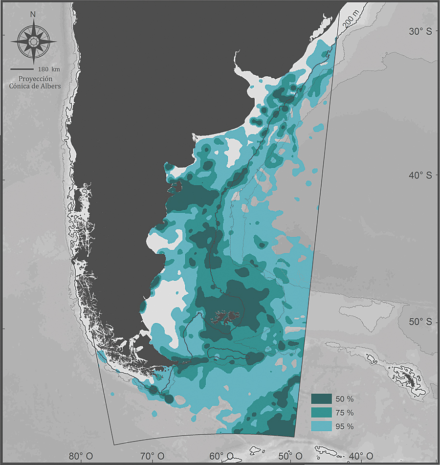
Researchers used GIS to generate a map showing the localization data of elephant seals, as well as their density distributions and utilization distribution contours.
Contours indicate the distribution range of the animals studied and identify areas with similar probabilities of occurrence. Researchers quantified the duration of time that a species stays in a location. Zones identify where individuals spent 50 percent of their time. The 50 percent contour reveals the areas of highest density or probability of the species being in that location.
WCS integrated data from all 16 of the study's targeted species into the GIS to create a composite view of Patagonian Sea ecosystems.
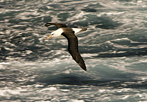
The southern seas and coastlines of Argentina and Chile, known as the Patagonian Shelf, are a habitat to albatross, colonies of Magellanic penguins, and pods of right whales.
The Study Conclusions
The most important areas are the waters adjacent to the Malvinas Islands, Staten Island, Diego Ram�rez Islands, and the Vald�s Peninsula, as well as those stretching from the south of the peninsula to the north of the Gulf of San Jorge.
The most important pelagic areas are the oceanographic front associated with the slope of the Patagonian Shelf, the ocean environment adjacent to the Malvinas Islands, the shelf-slope region at the latitude of the Gulf of San Jorge, the areas influenced by the outflow of the R�o de la Plata, and the vicinity east of the Burdwood Bank.
Relevant areas of importance are the waters of the polar front at the southeast end of the target area and a coastal-pelagic corridor between the Vald�s Peninsula and the shelf-slope.
Researchers could readily see that none of the pelagic areas identified as important for top predators is under a regime of special management for conservation biodiversity. The study provides insight for the biological zoning of the ecosystem and gives scientific credence to policy recommendations for open ocean marine protected areas.
"GIS has been one of the most important tools that the project has used to identify relevant ocean areas and promote the conservation of the Patagonian Sea," says Valeria Falabella, a marine biologist and the assistant director of WCS Sea and Sky. "WCS has been promoting the concept of landscape species and conservation at the landscape dimension, integrating species and spaces in a unique methodology to guide conservation all around the world. Esri and Aeroterra have been fundamental to these efforts by providing software, training, and technical support to the project."
The Atlas of the Patagonian Sea web page is an excellent tool for research and education. Site visitors can interact with maps and download high-resolution maps. See it at www.atlas-marpatagonico.org.
For more information, contact Valeria Falabella, marine biologist and assistant director of WCS Sea and Sky, Wildlife Conservation Society (e-mail: vfalabella@wcs.org), or visit www.atlas-marpatagonico.org. The completion of Atlas of the Patagonian Sea is due in large part to the generosity and long-standing support of the Liz Claiborne and Art Ortenberg Foundation for the WCS Sea and Sky initiative, as well as support from Judith H. Hamilton, James M. Large, Christopher B. Hockett, and Isabella Rossellini. WCS's conservation work in this region also receives support from the Mitsubishi Foundation for the Americas and Mr. and Mrs. James M. Large, Jr. Falabella also provided information for this article.