Indonesia NSDI: One Map for the Nation
Highlights
- ArcGIS for Server and Esri Geoportal Server provide the foundation for the National Spatial Data Infrastructure.
- Data is being made more readily available across the nation through the GIS-based NSDI.
- Government agencies can now easily share geospatial information.
Indonesia, nestled in the Indian Ocean, is the largest archipelagic country in the world. With the proliferation of complex national development tasks, such as rebuilding after the 2004 Boxing Day tsunami, the need for geospatial information has proved to be a necessity. GIS is an important tool for helping decision makers formulate, implement, monitor, and evaluate national and regional development plans. The technology has proved itself in construction and management of various development and infrastructure projects; emergency measures against natural disasters; environmental protection policies; land use; the cadastral system; forestry, agricultural, land, and building tax; and statistics, marine affairs, and mineral resources management, among many others.
Providing access to authoritative data to provinces, local governments, and the private sector through an easy-to-use online portal will increase the use and benefits of the data.
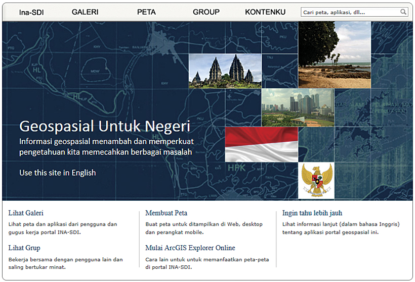
Indonesian NSDI
A National Spatial Data Infrastructure (NSDI) is now being introduced throughout the country to help GIS proliferate while reducing the duplication of effort among agencies, improving data quality, and reducing costs. The project is undergoing the early stages of development, ensuring all institutions have the required technology to implement the system.
The Japanese government's Japan International Cooperation Agency provided a loan to the Indonesian Geospatial Information Agency (Badan Informasi Geospasial). NTT Data, a Japanese-owned company experienced with IT integration, is overseeing implementation. ArcGIS for Server and Esri Geoportal Server are the foundation of the national system. NTT Data and its Indonesian counterpart are implementing the project with guidance from Esri Professional Services. This spatial geoportal will provide access to the geospatial data throughout the country.
Success of the NSDI relies on institutes and national data producers, including provinces and local governments, as well as the private sector, all working together. The goal is to increase data availability to make it easy to find, access, and use online. This in turn will make geospatial data more accessible to the public, increasing its benefits.
Creation Through Legislation
The road to Indonesia's NSDI began with a historic move: the establishment of the Geospatial Information Act on April 21, 2011. Passage of this act has three main advantages: increased access to reliable geospatial information, more effective delivery of geospatial information, and the ability to use that data throughout the country. More effectively sharing necessary geospatial information between ministries was the goal.
With every cabinet meeting requiring that geospatial data be displayed, however, the reality of using geospatial data set in. Every ministry and nonministerial institution had to prepare its own data to report on the progress of national development.
In the beginning, the issues were related to questions of how to present the information on a map. Once government staff learned to represent their own datasets on a map, integrating the data with other ministers' datasets turned out to be just as challenging. Different scales and formats made sharing information as the legislation requested a difficult task.
Esri Geoportal Server provides the foundation for geospatial data that can be used across Indonesia.
Better Data Access Through NSDI
These challenges made access to authoritative data that could be easily shared between parties very important. The logical step forward was to implement an environment in which stakeholders, using technology, standards, and shared geospatial information, could interact to better achieve their objectives at different political or administrative levels. On August 3, 2007, the Regulation of the President of the Republic of Indonesia No. 85/2007 took effect for the implementation of the NSDI.
The NSDI project will help achieve good governance of Indonesian geospatial data between national, provincial, and local governments, as well as nongovernmental organizations. The NSDI will support more efficient administration, especially in eliminating duplicate sets of the same data. The vision is for geospatial data to be more easily acquired and created throughout the island nation by a strong foundational system. This will support regional development planning for provincial governments, as well as manage natural resources, protect the environment, and mitigate natural hazards, ultimately contributing to the overall economic development of Indonesia.
GIS Is BIG in Indonesia
The agency charged with this vision is the National Coordinating Agency for Surveys and Mapping (Bakosurtanal), which is evolving into the Geospatial Information Agency (BIG). Before the Geospatial Information Act, Bakosurtanal was responsible for only providing basemaps up to a scale of 1:25,000. The new mandate for the agency will be to provide an implementation strategy and funding for basemaps at various scales, from 1:1,000,000 all the way to 1:1,000.
Managing the NSDI project will involve many complex activities related not only to administrative matters but also to creating the right technical environment within government institutions to be able to evaluate, select, and manage geographic information. The first phase of the project will be completed by mid-2013 and will involve nine state institutions and two provincial governments. It will be considered successful if the developed NSDI complies with the original operational concept, uses approved standards, and increases the usefulness of Indonesia's geospatial assets.
Once the NSDI is established, every institution involved will be thinking of how to keep the momentum of this historic project going. More participants will be included, more applications designed to use the system, and a working committee created to continue to define the direction and policies of this national treasure.
For more information, contact Antonius Wijanarto, head of the Metadata Division, Bakosurtanal (e-mail: anton@bakosurtanal.go.id), or Anak Agung, Esri (e-mail: agung@esri.com).