Introducing ArcGIS 10.1
Integrated Platform Enables Greater Collaboration
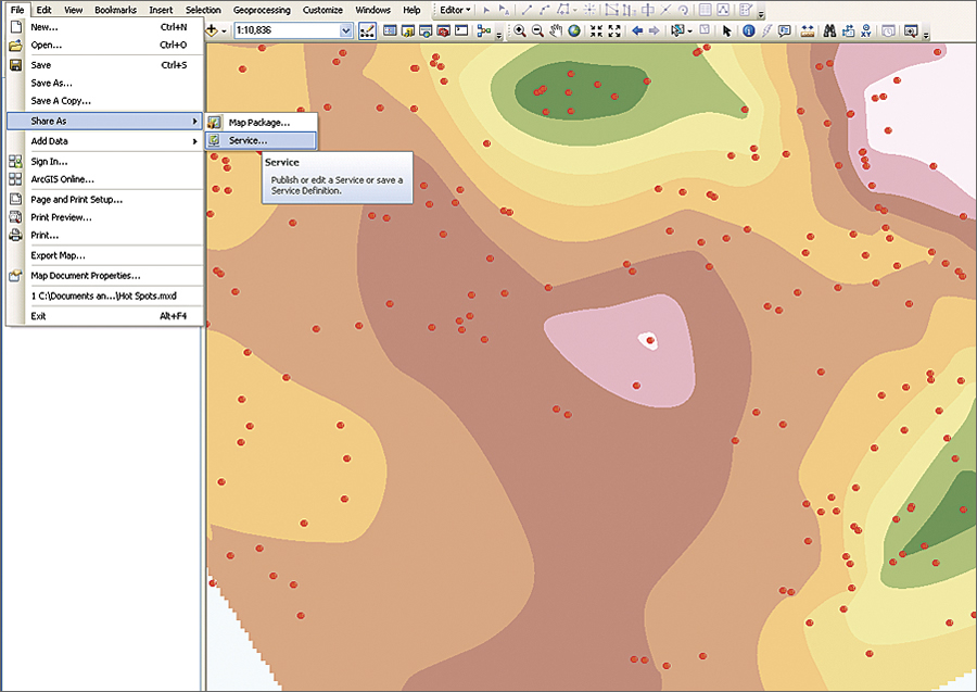
At 10.1, ArcGIS for Desktop can deliver any GIS resource, including maps, imagery, geodata, and tools, as a web service.
The release of ArcGIS 10.1 signals a major development in the way geographic information will be accessed and managed by GIS professionals and their organizations in the years to come. ArcGIS 10.1 gives GIS professionals a complete GIS that further integrates desktops and servers, as well as mobile and web applications. It provides organizations with the additional tools and infrastructure they need to extend the reach of their existing GIS. It also improves organizations' ability to transition to next-generation GIS concepts and platforms without jeopardizing their current GIS investments.
New to ArcGIS Online is ArcGIS Online for organizations—a customizable, web-based system designed for professionals who want to manage their organizations' geospatial content using cloud tools and infrastructure. It allows administrative control over data creation and access while making geographic information easily available to others within the organization, as well as beyond the organization in collaborative efforts with others. (see "The City of Salem, Oregon, Broadens the Reach of GIS").

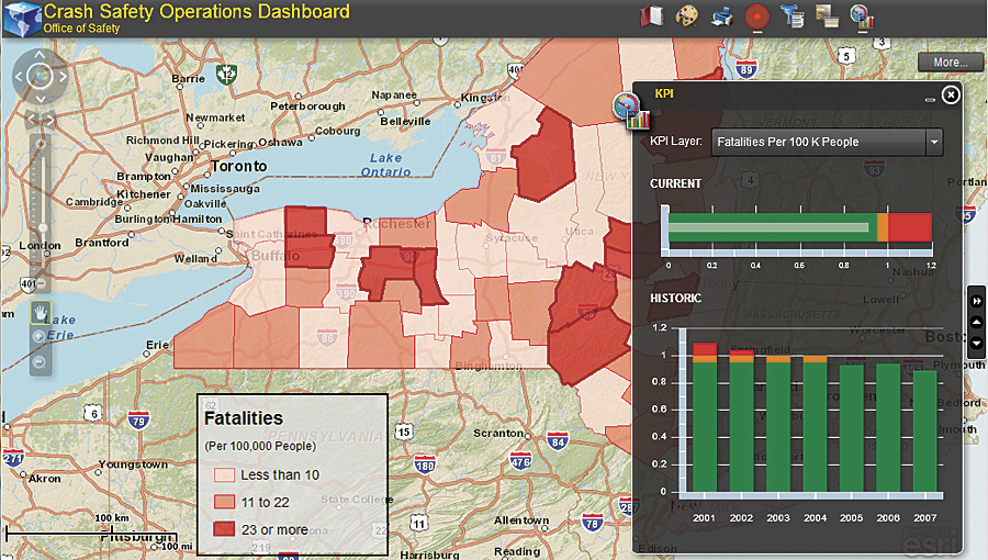
ArcGIS 10.1 users can customize map templates and deploy them as interactive community dashboards that allow citizens to view and report incidents, such as crime.
ArcGIS Online is now a fully integrated, easy-to-use portal for thousands of GIS professionals around the world. In addition to users, organizations can store and manage their maps, data, and other geospatial information on ArcGIS Online, as well as access thousands of free maps, datasets, services, and tools. Esri continuously updates ArcGIS Online content to deliver new map, image, and task services so that users are always getting the latest, most accurate, and best cartographic basemaps and GIS products available anywhere on the web.
At 10.1, ArcGIS for Server runs natively on 64-bit Windows and Linux operating systems, providing users with high-performance web editing and map caching, on-the-fly analyses, and imagery exploitation capabilities, as well as additional choices for deployment. In addition to being fully certified on VMware and VCE's Vblock platform, ArcGIS for Server can be deployed on Amazon Elastic Compute Cloud in both Windows and Linux. ArcGIS for Server includes new services, such as a print service that allows users to produce high-quality, large-format PDF maps directly from web maps. Also new at 10.1, along with the ability to generate sophisticated GIS and mapping services with Standard and Advanced editions, all editions of ArcGIS for Server, including Basic, will provide simple mapping capabilities from a database.
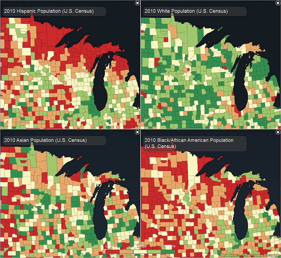
In this example, dynamic layers (new at 10.1) provide web application developers with complete freedom to define how multiple layers within a service are displayed. Here, four synchronized map layers from the same service are individually symbolized and arranged for visual analysis.
GIS professionals will find this release of ArcGIS for Desktop to be the most empowering GIS authoring environment to date. With ArcGIS for Desktop, users can now deliver any GIS resource, including maps, imagery, geodata, and tools, as a web service on both ArcGIS for Server and ArcGIS Online. Desktop users can also easily package their maps and layers and make that content available to staff, stakeholders, partners, or the public via online groups while maintaining complete control and ownership of their content.
Mobile developers now have access to a suite of ArcGIS Runtime Software Developer Kits (SDKs) to create custom business applications for iOS, Android, and Windows Phone devices. Developers are able to create apps that use the powerful mapping and geocoding capabilities found in ArcGIS for Server and ArcGIS Online. These apps can be deployed within an enterprise environment or to the public via the Apple App Store, Microsoft Marketplace, and Android Market. In addition, a free, out-of-the-box ArcGIS application lets users explore map content, collect and edit GIS features, and use sophisticated geoprocessing tasks. The ArcGIS app is available for download on all major mobile platforms.

Even small communities, such as the Town of Groton, Connecticut, can use ArcGIS 10.1 to promote economic development opportunities and provide detailed land record information.
At 10.1, developers will gain even greater access to the ArcGIS system via improved APIs and SDKs for web and mobile applications, configurable viewers, and the new ArcGIS Runtime. ArcGIS Runtime allows developers to create and deploy focused, stand-alone GIS applications for desktop users. The runtime is a small, lightweight deployment that, in terms of capabilities, fits between ArcGIS Engine and the ArcGIS web mapping APIs. The new runtime is designed for both desktop and cloud development. It has a fast display and does not require installation; it can be run directly from a CD.
Learn more about what's new in ArcGIS 10.1.

ArcGIS 10.1 will simplify the job of creating interactive, web-based maps that geoenable stories and events anywhere in the world, even for scientific expeditions, such as the one led by Oceans North Canada to track one of the greatest whale migrations in the world.
Improved web APIs and templates provide ArcGIS 10.1 developers with a rapid development framework for spatially enabling data over time and geography.