James Cameron—A Unifier Many Times Over
GIS Hero
James Cameron
As Applications Section administrator for the Information Technology Bureau of the South Florida Water Management District, James Cameron works to provide flood protection for millions of area residents. His efforts help monitor water quality, treat storm water, and restore the Everglades. For Cameron, a native Floridian, his career is a way to express his deep love for the state and a strong appreciation for the environment.
Cameron grew up in south Florida. He fished Biscayne Bay with his family and camped with his Boy Scout troop at Virginia Key, Mineral Springs, and Fortymile Bend in the Everglades. He later graduated from the University of Florida with a bachelor's degree in geography and a certificate in Florida studies.
"After college, I was acutely aware of how important water is in shaping the development of Florida," Cameron says. "I felt I could contribute in a capacity of public service in protecting Florida's precious environment."
Cameron was hired as a water resource planner, and later appointed GIS manager, at the Suwannee River Water Management District (WMD). He began to see the potential for GIS to bring clarity to complex water management issues, a way to transform large volumes of hard-to-interpret information into data and maps that could be easily understood by those responsible for making water management policy decisions.
"Once I realized my work could provide management with the ability to make better-informed decisions, I was hooked; GIS was my career," Cameron says. "What I love about GIS is that we can put maps in front of decision makers, show them where the issues are so they can understand complicated data and environmental issues, and see relationships between various factors."
One of the major accomplishments during Cameron's six years at the Suwannee River WMD was the initial implementation of GIS. Data had to be put into the system, which, in most cases during the early 1980s, meant using a digitizing table to capture information from paper maps. The team constructed basemaps by digitizing hydrography, roads, the Public Land Survey System, jurisdictional boundaries, and hypsography. Along with the basemaps, team members also digitized data layers, such as surface water drainage basins, soil surveys, and locations of groundwater monitoring wells. With the foundation of GIS complete, the Suwannee River WMD was ready to apply GIS in support of its projects and programs.
GIS played an important role in the implementation of the Suwannee River Basin Floodplain Development Ordinance that keeps people from building houses below the 100-year flood elevation in floodplain areas. Another accomplishment was the use of GIS to derive storm water retention and detention standards from delineated watersheds to support the Surface Water Management Program.
For the past 12 years, Cameron has worked with the South Florida Water Management District directing GIS development. The focus of this GIS has been the integration of both data and applications, including the development of a common hydrographic data model.
Steve Dicks studied with Cameron at the University of Florida, and the two worked together through college as roadies for rock 'n' roll shows. Dicks, who is now the information resources director at Southwest Florida Water Management District, recalls the important, early contributions Cameron made to statewide mapping.
"Jim has been a leader in feeding the statewide database with soil surveys for modeling and surface water permitting, statewide aerial photography, and digitized USGS maps," Dicks notes. "He is a big thinker. The role he played in coordinating that—he was able to get five government agencies moving in the same direction."
Building a GIS Career
Over the years, Cameron has had many job titles in several organizations, from GIS manager and director of GIS applications to chief GIS officer and GIS Division director. However, his role has always been to guide and direct the implementation of GIS to support the mission of the organization.
In the 1990s, Cameron worked as the GIS manager at the St. Johns River Water Management District, where he contributed to the development of the US Geological Survey (USGS) topographic quad updates, digital line graphs, digital raster graphics, orthophotos, and National Aerial Photography Program. One of the most significant accomplishments, according to Cameron, was the creation of a detailed land-cover/land-use dataset needed for a variety of applications, including wetland change-over-time analysis and estimates of non-point source pollution loading to surface water bodies.
In 1997, Cameron was appointed by Florida governor Lawton Chiles as the water management district member of the Florida Geographic Information Board. That same year, he and his team were able to assist fire crews with detailed maps, saving homes and property. The following year, working with a contractor, Cameron and his team developed and implemented a methodology to produce gauge-adjusted Doppler rainfall estimates. A modification of this methodology is currently being used by water management districts throughout Florida.
David Maidment, director at the University of Texas Center for Research in Water Resources, recalls seeing Cameron's work many years ago at the Esri International User Conference. "The map of groundwater recharge constructed for the St. Johns River Water Management District remains still a great example of the use of core GIS functions to support geospatial analysis of water resources."
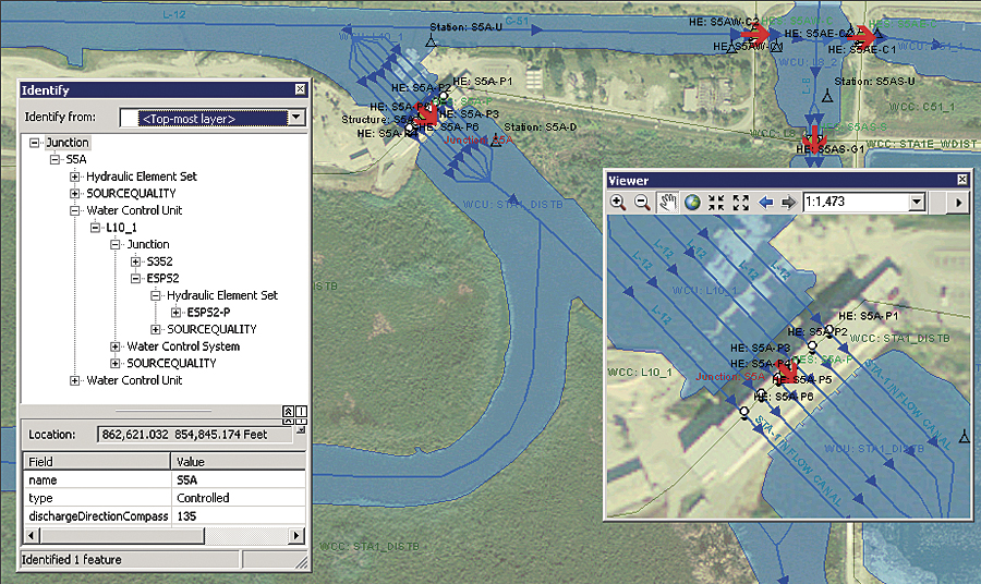
More recently, Maidment says he has admired Cameron's work as a leading advocate of the use of GIS for water resources at the South Florida Water Management District. Instead of having a set of unconnected streamlines, drainage areas, water control structures, and water measurement points, Cameron's efforts have made all the information geographically consistent such that the drainage area outlets fall right on the water control structures and the corresponding streamlines, and all are connected with relationships.
"It was like seeing a fuzzy image suddenly come into a precise focus," Maidment says. "Jim is a great GIS leader with a lifetime of contributions to the field of applying GIS in water resources in Florida."
Leadership on Many Levels
For the past 12 years, Cameron has worked with the South Florida Water Management District and continued the role of directing GIS development. Here, Cameron says, the focus of GIS has been toward integration of both data and applications, including the development of a common hydrographic data model.
Now, one unified database houses hydrography; drainage basins; hydrologic monitoring sites; and hydrologic elements, such as pumps, culverts, and weirs. The unified database provides the ability to define relationships among the hydrographic elements that can then be used for hydrologic modeling. This common hydrographic data model is being incorporated as a foundation component along with the district's SCADA system and a business rules management system to create an operations decision support system that will provide a key resource to water managers. This means the data and GIS tools will support the district's work to provide flood protection for millions of residents of South Florida.
"I have been blessed to lead a team of dedicated GIS professionals who have implemented a GIS that is used by the entire agency," Cameron observes. "As the district staff learn and use existing applications, they begin to understand the power of GIS and how GIS can be applied to meet other business objectives."
Tim Minter, a GIS enterprise architect with the South Florida Water Management District, remarks on not only Cameron's skills in the application of GIS but also his effective management style.
"Jim has a consistently keen eye for spotting significant opportunities to advance the application of geographic information science and technology in water resource management communities," Minter says. "He delivers meaningful and successful GIS services because he builds and supports strong teams by supporting team members' professional interests and growth, highlighting individual and team achievements, and caring about his staff on a personal level."
For more information, contact James Cameron (e-mail: jcameron@sfwmd.gov).