RCN—Strike Up the Broadband!
Highlights
- ArcGIS helps RCN realize more accurate and efficient management.
- GIS makes it easy to enter and update network connectivity.
- ArcGIS provides a consistent database that tells RCN where its network is and how it is connected.
Expansion across its big-city markets raised a key network documentation challenge for RCN Telecom Services, LLC, based in Princeton, New Jersey.
RCN is a competitive broadband service provider that delivers all-digital and high- definition video, high-speed Internet, and premium voice services. Its services are available to residential and small-to-medium business customers under the brand names RCN and RCN Business Services, respectively. RCN's primary service areas include Washington, D.C.; Philadelphia and Lehigh Valley, Pennsylvania; New York City, New York; Boston, Massachusetts; and Chicago, Illinois.
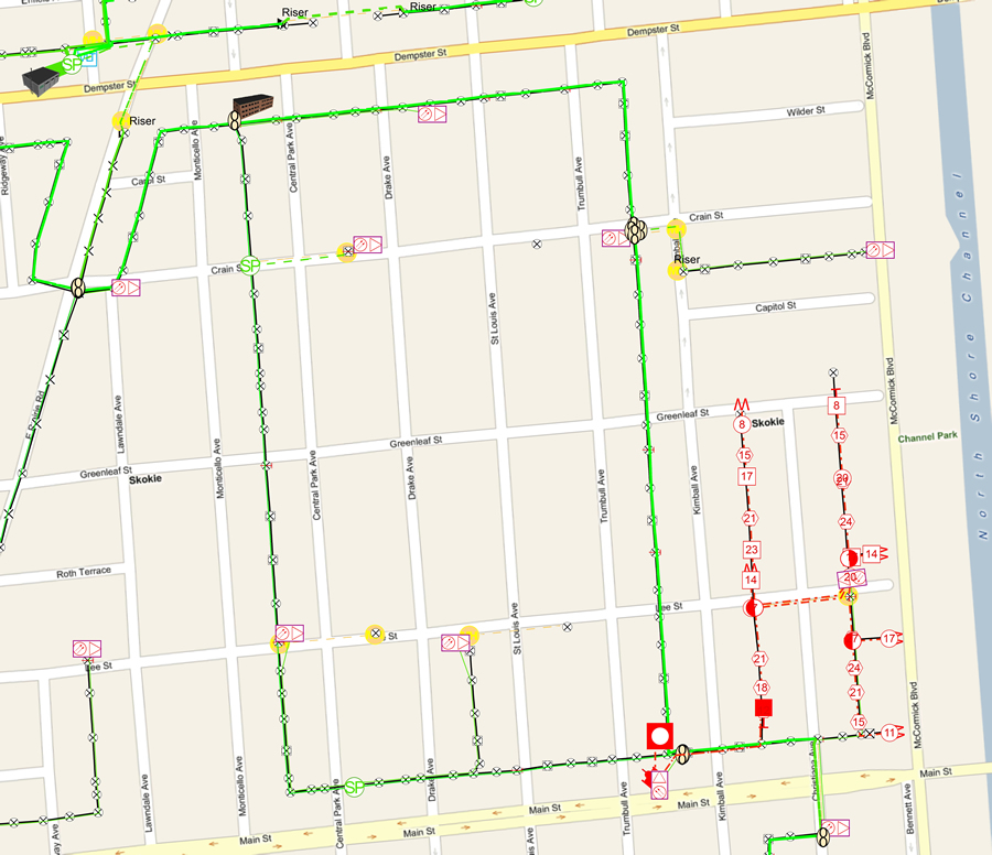
RCN can view its network elements such as the hub site (upper left), fiber-optic-fed commercial buildings (top center), the fiber-optic network out to the node, and the coaxial facilities out to the taps in front of the customer's home.
RCN provides services through an advanced hybrid fiber-coaxial network, a platform that increases high-definition availability for improved picture quality, to cable TV customers and enables cable modem speeds that challenge industry standards. These capabilities—and the company's culture of innovation—are supporting the organization's successful expansion in its strategic Northeast Corridor and Chicago markets.
In preparing for this expansion, RCN operators noted that the company's fiber-optic networks were documented through various and multiple systems including CAD maps, stick drawings, splice diagrams, and splice sheets.
"For all the service territories, there must have been hundreds, even thousands, of CAD documents," says Chris Augustine, RCN network engineering manager.
Augustine explained that RCN staff wanted to move away from paper and toward a GIS-based solution. The GIS had to be able to tell network personnel where the fiber-optics were physically located, how much was available, and how many nodes there were for any hub site. Such information was necessary to streamline asset management and customer service.
After evaluating several vendor products, RCN selected the Fiber Manager solution from Esri partner Telvent USA Corporation of Fort Collins, Colorado. Fiber Manager is an extension of Telvent ArcFM Enterprise GIS, which is based on the ArcGIS platform. Augustine and his team found that the GIS solution made it easy to enter, update, and work with network connectivity.
Implementation began in 2009 with a small pilot project and was extended through all RCN service territories, with almost 100 percent of the company's extensive fiber-optic network database completed in late 2010.
Standardized Network Asset Management

GIS gives RCN the ability to manage its network assets more effectively by including information about the surrounding areas, such as satellite imagery.
All RCN markets now operate with a common and centralized network infrastructure management system that supports efficient communication, planning, and reporting. Operations within each service territory share a central database that is updated to provide more accurate information to everyone.
"We can now locate fiber assets from our office," says Augustine. "We don't have to spend the time and labor to visit the field to identify and confirm assets."
Flexible Data Modeling
Fiber Manager's Flexible Data Model sparked RCN's innovative juices. Working with Telvent, RCN capitalized on the ability to extend the solution to include the coaxial network. The addition of coaxial facilities to the data model was done completely through system configuration and did not require customization. Now, having modeled its network, the resultant completed management system is maximizing RCN's investment in GIS technology.
This is the first GIS-based hybrid fiber-coaxial application of its kind. It offers the ability to trace the communications network from the fiber-optic patch panel through the fiber-optic and coaxial network to the final destination, a home or other customer. It also allows tracing of the radio frequency power network separately. This ArcGIS software-based capability helps RCN realize more accurate and efficient management of each component of the communications network and optimize maintenance and customer service.
"The segregated tracing allows us to separately monitor two different networks in one system," Augustine says. "In addition, we can easily track customers and equipment affected by an outage anywhere along our network."
Customer Database Management
Accurate geodatabase profiling of its fiber-optic networks using ArcGIS helps RCN easily identify the proximity of existing network assets to customers and noncustomers. This information has been highly valuable in helping RCN efficiently recruit new customers and assess the cost and returns of potential network expansions.
With improved management of its advanced fiber-optic and coaxial networks, RCN is able to implement network expansion more efficiently, optimize customer satisfaction during the process, and retain customers to stay ahead of the competition.
"The biggest advantage we have found with GIS is a consistent database that tells us where our network is and how it is connected," Augustine says. "It gives us the ability to put that information in the hands of everyone who needs it."
For more information, contact Chris Augustine, RCN (e-mail: chris.augustine@rcn.net), and visit Telvent or Esri at esri.com/telecom.