Realizing a MAGIC Vision
Local Iowa Consortium Raises Data-Sharing Bar
Highlights
- ArcGIS for Server cached image services display, in just moments, multiple years of orthophotos.
- Using ArcGIS Viewer for Flex and ArcGIS API for Flex, custom web applications were created for each partner organization.
- With GIS, all partners share precise and current copies of the master parcel data maintained by the county.
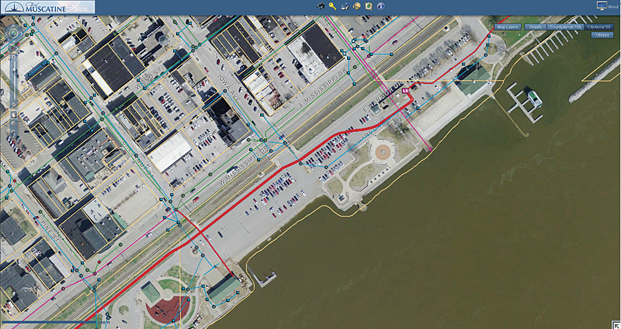
Final network configuration that allows Muscatine Area Geographic Information Consortium's (MAGIC) three principal partners to use MAGIC's ArcGIS for Server map services over a private segment of the Muscatine Power & Water (MPW) municipal area network.
Located on the Mississippi River just 20 miles downriver from the better-known Quad Cities, Muscatine, Iowa, became known as the Pearl Button Capital of the United States in the late 19th and early 20th centuries due to its abundant supply of river mussels and innovative citizens who knew how to take advantage of that resource. While that early industry has since faded, Muscatine has spawned numerous other local innovations over the years, one of which is a local GIS consortium created in 1999 and known as the Muscatine Area Geographic Information Consortium, or MAGIC—the first such local GIS consortium in Iowa. MAGIC's principal partners are the City of Muscatine, Muscatine Power & Water (MPW), and Muscatine County.
MAGIC's Mission and Initial Implementation
MAGIC is a product of chapter 28E of Iowa Code, which enables local governments to enter into cooperative agreements to provide common services to their respective communities. As stated in its charter, MAGIC's mission is to "improve the efficiency and effectiveness of its member organizations through the coordinated development of geographic and land information systems (GIS/LIS) technology and data."
To achieve this goal, MAGIC's initial investment focused on constructing a centralized, high-quality, photogrammetric basemap that could be accessed over a newly constructed fiber-optic municipal area network built by Muscatine Power & Water's new communication division. Supplemental data layers would then be compiled in this accurate basemap.
Procurement of the photogrammetric basemap component was straightforward, thanks to the funding strength made possible through cost sharing by the three partners, along with the quality specifications provided by MAGIC's initial consultant, GeoAnalytics of Madison, Wisconsin. Actual development of a central data repository was a trickier matter. Due to a variety of impediments, MAGIC postponed the initial goal of a centralized geodatabase to a later date and instead opted to initially develop the community GIS as a disconnected system.

The City of Muscatine bike trail along the Mississippi River is lit with period lamps known as the "String of Pearls."
While the disconnected environment solution was less than optimum, MAGIC and partner staff remained undaunted and moved forward in developing an array of GIS datasets, such as a survey-accurate, three-dimensional, storm water/wastewater geodatabase for the City of Muscatine; electric, water, cable, and fiber-optic geodatabases for MPW; and a robust parcel database for Muscatine County.
Solving the Largest Problem
The single largest problem with maintaining GIS datasets in a disconnected environment is keeping the data current and synchronized. While these shortcomings were never serious, they were nevertheless a constant reminder that a more centralized approach was needed, so by 2007, MAGIC was ready to take a closer look at ArcGIS for Server technology as a possible solution.
MAGIC staff attended a system architecture and design class in July 2008 and learned to estimate computer hardware and communications needs for a viable system.
MAGIC's implementation goals focused on one simple metric: keeping screen refresh times for end users under five seconds. From past experience, MAGIC staff had found that end users would not use GIS services if screen refreshes took longer than five seconds for a pan or zoom. Because of the storage size required for MAGIC's 2000, 2005, and 2010 countywide orthophoto flights, the biggest concern involved ensuring that any display of MAGIC's multiple years of orthophotos would stay under the five-second display threshold. ArcGIS for Server cached image services promised to provide the solution needed to meet this demand.
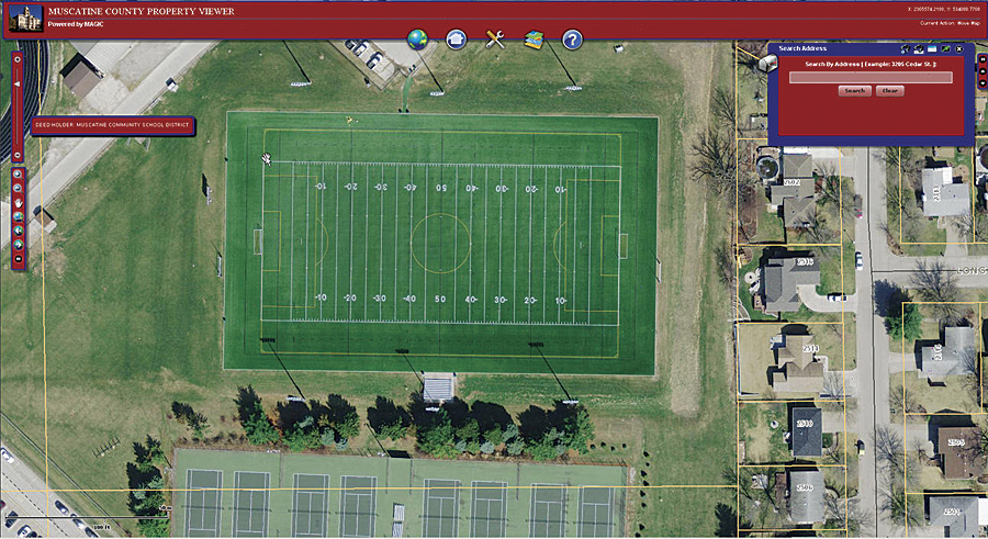
Muscatine County Property Viewer is a customized version of ArcGIS Viewer for Flex version 2.4. City staff members use the viewer to access map services on MAGIC's server.
A second, but no less important, concern involved providing MAGIC's partner organizations with fast remote access to MAGIC's central server. Fortunately, equipment upgrades and price reductions in 2008 for MPW's local fiber-optic wide area network (WAN) made an initial intranet testing phase of ArcGIS for Server affordable for all partner organizations, and their respective governing boards gave a green light to proceed.
Final design steps involved calculating the data transfer rates needed to achieve refresh times of five seconds or less over MPW's WAN. By quantifying local system variables, MAGIC staff estimated that adequate refresh speeds could be achieved for MAGIC's approximately 50 users with a 10 Mbps intranet connection for each partner and a single robust MAGIC server.
MAGIC purchased its server in September 2009 and spent two months configuring it and testing the WAN connections from each partner organization's location. In the end, user refresh times met or exceeded initial designs.
Realizing the Vision of a Centralized Data Repository
With the server technology installed and the local communications network established, staff members moved personal geodatabases that had been maintained on MAGIC's old file server to MAGIC's new centrally located ArcSDE geodatabases for use in creating map services of MAGIC's custodial data. Additionally, MAGIC was able to replicate Muscatine County's enterprise parcel geodatabase to MAGIC's server so that city and MPW staff could have access to an exact and fresh copy of the master parcel data maintained by the county. Finally, the City of Muscatine's storm water and wastewater personal geodatabase was migrated to an enterprise geodatabase on the new MAGIC server. This migration has introduced a new dimension of editing to city staff: multiple versions of the geodatabase are now checked out to field crews, office staff, and department supervisors, and each group independently edits them as needed. Using ArcSDE versioning functions, users post changes back to a master geodatabase, and any conflicts that arise are easily detected and reconciled.
Another powerful aspect of this server technology involves the use of custom web applications to extend GIS technology to the desktops of staff that formerly had no access to GIS functionality. Using ArcGIS Viewer for Flex and ArcGIS API for Flex, provided by Esri, staff created custom web applications for each partner organization, which has increased the number of GIS users by 30 percent.
Multijurisdictional Enterprise License Agreement
Another vital factor in the success of MAGIC's ArcGIS for Server migration involves the multijurisdictional enterprise license agreement (MJ-ELA) that MAGIC has with Esri. This updated version of the original 2009 ELA, which was for municipal partners only, has now expanded the scope to cover all MAGIC partners and eliminates the previous ELA boundaries between county and city governments. This has resulted in lower annual software maintenance costs for Muscatine County, has opened up software access to MAGIC's smaller affiliate members, and now provides an equitable software maintenance solution for all partners. Moreover, access to enhanced software functionality through the MJ-ELA makes it more feasible for MAGIC to test advanced ArcGIS for Server applications, such as deploying mobile GIS once the anticipated citywide Wi-Fi network is established for the Muscatine community.
Summary
Most successful projects share the common attributes of being flexible and persistent and having the ability to change as technology advances. In MAGIC's case, despite early roadblocks, the persistence of its staff has developed the project to the point where it can take advantage of new enterprise server technology. The synergistic result promises to be a quality mapping and GIS infrastructure that will serve the Muscatine community for many years into the future.
For more information, contact Mark Warren, MAGIC GIS manager (tel.: 563-263-2631, e-mail: mwarren@mpw.org).