The Rivers Agency, Northern Ireland
Raising Awareness of the Risk of Flooding from Rivers and the Sea
Highlights
- The Strategic Flood Map attracts more than 300 infrastructure and business visitors per week.
- Built with ArcGIS technology, the Strategic Flood Map defends against future flooding incidents.
- The Esri data center in Dublin hosts the viewer.
Whether caused by rivers, the sea, or surface water, flooding can have a devastating impact on communities. A number of serious floods have occurred in recent years across Northern Ireland that have resulted in considerable damage to both businesses and homes.

December 2011—The Strategic Flood Map was updated to include surface water flood mapping (flooding from short-duration, high- intensity rainfall).
In response to these natural events, the Rivers Agency of Northern Ireland has launched a Strategic Flood Map to encourage a more proactive approach to flood risk management. Commissioned by the Rivers Agency, this online service makes information about flooding more accessible to public-sector organizations, infrastructure providers, private businesses, and the general public.
The Rivers Agency is an executive agency within the Department of Agriculture and Rural Development and is the statutory drainage and flood defense authority. Its aim is to reduce the risk to life and damage to property from rivers and the sea and undertake watercourse and coastal flood management in a sustainable manner.
In 2008, extreme rainfall impacted a third of the region and resulted in widespread flooding that caused damage and misery for thousands of people. The Rivers Agency recognized that the risk of further flooding was not only high but likely to increase in the future according to climate change predictions.
Against this backdrop, the agency has developed a flood map that is consistent with its new, more strategic approach to managing floods.
"Our approach to managing floods in the past, and that of the whole flood defense industry, was mainly reactive—we simply dealt with flooding incidents as they occurred," explains David Porter, director of development at the Rivers Agency. "We realized new technology enabled floodplains to be identified with a good degree of accuracy, and this enabled a more proactive approach to be taken whilst still maintaining a capability to react to actual flood events."
The agency started to implement a wider range of measures as part of its flood risk management strategy. This broader approach is consistent with the requirements of European legislation known as the Floods Directive, which outlines the approach in the terms of three Ps: prevention, protection, and preparedness. Prevention is ensuring that inappropriate developments are not built in areas of flood risk, protection is building barriers or other measures to stop water from reaching property and people, and preparedness is making people aware of potential risks so that they can make plans to protect their homes and businesses.
Traditionally, the Rivers Agency had concentrated on protection. Now, however, it wanted to develop its ability to support prevention and preparedness. To succeed with this, it knew that it would need to make information about flood risks more accessible to the general public, partners, and stakeholders. It therefore decided to develop an online map viewer to display information about past and future flooding risks.
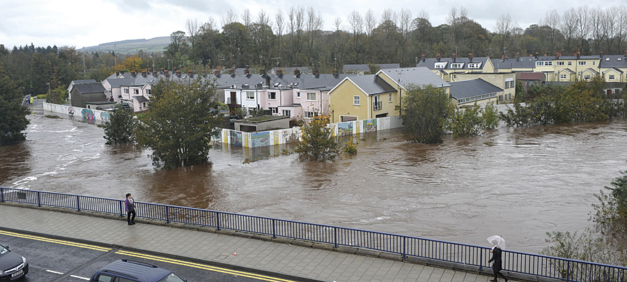
October 2011—Significant flooding through Omagh, County Tyrone. The flood defenses protecting the town were threatened but not overtopped.
"We needed to be able to communicate information about the potential risk of floods and make maps of floodplains more accessible to individuals, businesses, and local authorities," Porter says. "It is important for people to know which areas are at risk of flood so that they can be prepared and take appropriate action."
Solution and Capability Delivered
Under the terms of public-sector procurement policies, the Rivers Agency appointed the RPS Group plc—Belfast Office as framework consultant to oversee the entire project. Esri Ireland, Esri's distributor, was then brought in as a subcontractor to provide the specialist GIS solutions and expertise. Staff from Esri Ireland listened to the organization's requirements, documented them, and built a prototype of the online map viewer. This prototype was then made available to a fairly large user group comprising technical and nontechnical staff from the agency, who put the solution to the test.
"User involvement in the development process ensured that we ended up with a map viewer that was suitable for users with mixed ability," says Malcolm Calvert from the Mapping and Modeling Unit within the Rivers Agency. "Ease of use was absolutely essential for a system that would be used by the general public."
Developed using ArcGIS technology, the online map viewer provides simple pan and zoom tools and location search features to make it easy for people to find, view, and interpret information about their locality. In addition to being responsible for the initial design and development, Esri Ireland was also called upon to host the solution from its data center in Dublin.
Currently, the online map viewer displays five different datasets, which together make up the Strategic Flood Map. Individuals and public and private organizations can go to the Rivers Agency website and use the map viewer to see
- Historical maps, incorporating archive aerial photography, that illustrate areas that have flooded in the past
- Flood defense maps that indicate the locations of existing walls, embankments, and other defenses and the areas protected by them
- Predictive flood maps, for present day and climate change epochs, and for various flood sources, including
- River (Fluvial) flooding
- Sea (Coastal) flooding
- Surface Water (Pluvial) flooding—which is flooding caused by short-duration, high-intensity rainfall
The Strategic Flood Map was launched jointly by the ministers with responsibility for flood risk management and land-use planning from the Northern Ireland Assembly in November 2008. Today, the ArcGIS software-based map viewer attracts more than 300 infrastructure and business visitors per week.

August 2008—When the River Lagan flooded, Northern Ireland experienced its wettest August since 1914. The floods caused widespread chaos across Northern Ireland and the Irish Republic.
By making information about flood risks more accessible to a wide number of organizations and the general public, the Rivers Agency has been able to encourage more proactive responses to flooding. Individual property owners, businesses, and local service providers alike have easy access to information about potential risks in their own locations and can be much more prepared.
"We know that there is a much greater awareness of flood risk now," says Porter. "When floods do occur, residents, businesses, community groups, and local authorities will be better prepared to deal with them."
The Rivers Agency's Strategic Flood Map helps it comply with European Union legislation and improves the availability of flood risk information to key stakeholders.
The map viewer has proved to be reliable, and the agency has received very few calls from customers reporting difficulties in using it. "Flooding can never be entirely prevented, but by acting together with other organizations and the public, we can help reduce its impact on people, property, and the environment," Porter says.
Wish List
The Rivers Agency intends to further develop its Flood Mapping communication over the next couple of years by adding data layers and giving users the ability to drill down to large scale to get much more detailed information.
For example, the agency has recently included surface water flood mapping and will soon be including information on flood risk from reservoir inundation.
At present, the Strategic Flood Map displays what are termed medium-probability events. In the future, the Rivers Agency will be publishing the flood risk from high- and low-probability events too. This will help users recognize the difference between frequent flooding and more extreme but unusual events and allow them to plan accordingly.
For more information, contact Malcolm Calvert, principal engineer, Department of Agriculture and Rural Development, Northern Ireland (e-mail: malcolm.calvert@dardni.gov.uk), or Joanne McLaughlin, Esri Ireland (e-mail: jmclaughlin@esri-ireland.ie).