Summer 2003
Summer 2003 |
|||||||
|
|
|||||||
ERICSSON Brazil Implements Enterprisewide GIS |
|||||
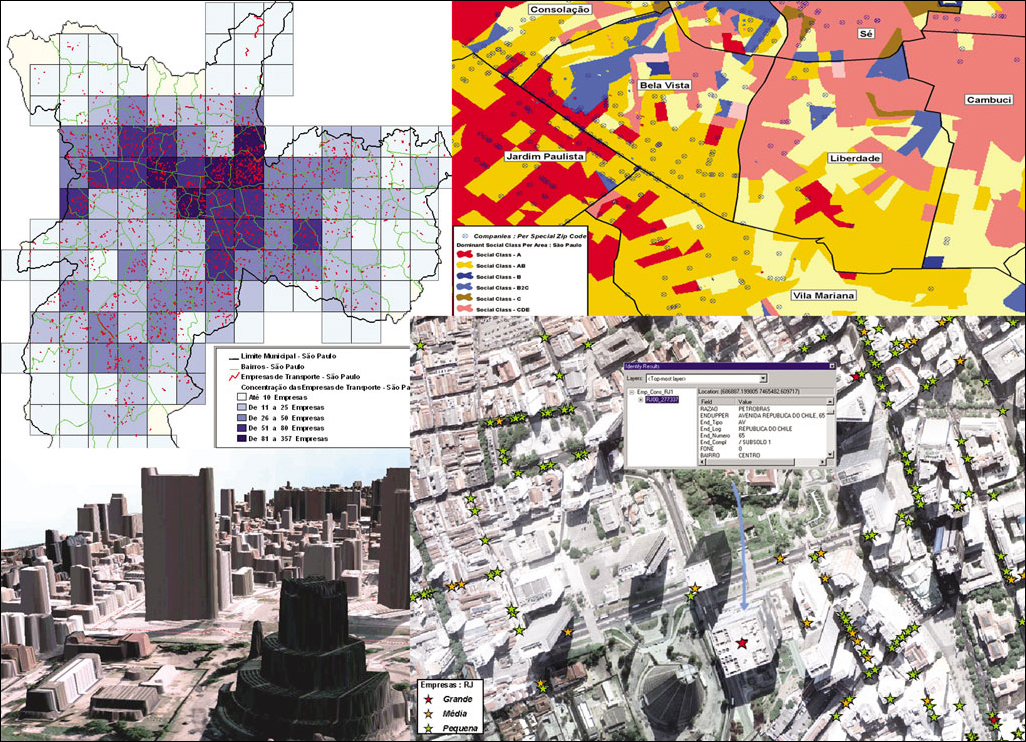
In response to market changes, the ERICSSON Brazil Business Consulting Division began the development of valuation methodologies for the telecommunications market, which identified business opportunities for existing products and evaluated the implication of new technologies. One of the primary technologies recognized by ERICSSON was GIS, which it uses for decision support processes. Besides financial analyses for projects, the division produces consulting projects using its knowledge in geomarketing such as performing cluster analyses in channel optimization, providing sales support, launching sales campaigns, and optimizing technical solutions in association with other ERICSSON divisions. Managers for ERICSSON's Business Consulting Division realized that using information from other divisions would increase the value of its studies although the integration of its business and engineering databases was highly expensive because of software incompatibility. In the beginning of 2002, ERICSSON's Business Consulting Division joined forces with Imagem Geosistemas E Comercio Ltda., one of Esri's Brazilian distributors, to sketch an innovative project involving the divisions of Business Consulting, Cellular Planning, Transmission Planning, and Core/Datacom Planning to design a GIS structure able to integrate and share the wealth of geographic information used by these divisions and to promote the usage of the GIS tools throughout the company at an enterprisewide scale. Under this concept, ERICSSON implemented its GeoNetWork project. The GIS infrastructure of GeoNetWork consists of Esri's GIS applications and server software. Because of its open protocol standards, it can be easily integrated with other applications used by ERICSSON such as TEMS for transmission and cellular wireless planning and VPI Access Maker for data communication network planning. An ArcSDE geodatabase was built to integrate and store business and engineering databases. Thus, by using the ArcIMS server, controlled sharing of information and GIS services delivery through the Web became possible, serving several of ERICSSON's divisions and clients across Brazil and worldwide. In general, the GeoNetWork project enhances ERICSSON's ability to provide strategic information for its engineering and business initiatives.
"GeoNetWork is a critical tool to enhance the flow of market capital intelligence throughout the different areas of ERICSSON," says Jesper Rhode Andersen, ERICSSON's vice president of Business Development, Customer Solutions and Sales Support, Brazil. "The concept of a corporate GIS enables the company to be extremely competitive in providing optimized solutions based on thorough understanding of the market. For example, some of our studies indicated that 80-85 percent of the corporate broadband demand in downtown Rio de Janeiro is highly concentrated in only 10-12 percent of the total existing buildings. With such a detailed level of marketing knowledge we can customize our solutions for the specific area where our client operates, optimizing the return on the investment. Our Business Consulting team further uses such valuable market knowledge of both residential and corporate customers to provide services such as producing sales guides, performing channel optimization studies, and structuring sales campaigns." ArcGIS 3D Analyst is used by the planning team to help in the design of cellular and transmission networks, using digital elevation models (DEMs) and a building heights database. ArcGIS Geostatistical Analyst is used by the Business Consulting team to analyze the probabilities and behaviors of markets and users. The new ArcPublisher extension enables the sharing of data and projects to ERICSSON's clients, minimizing the use of paper maps and plots. The GeoNetWork project places ERICSSON in an outstanding competitive position, adding to the currently supplied services the vision and values that are fundamental to GIS as a strategic information source for engineering and business strategies. ERICSSON is using this new work approach both internally and externally, where the clients can have real benefits, can participate in all stages of the process, can customize the development of the solution, and can obtain a more optimized result. For more information, contact Gustavo Barbosa Dias, Imagem (e-mail: gdias@img.com.br, tel.: 55-12-3946-8969). |