Summer 2003
Summer 2003 |
|||||||
|
|
|||||||
Fast, Efficient Data Integration, Analysis, and Display
Federated Department Stores, Inc., Uses GIS for Advanced Market Research |
|||||
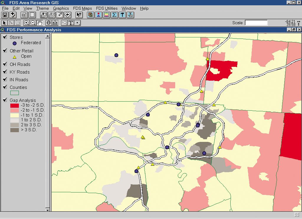
Today's technology helps businesses make sense out of a sea of data to better understand who their customers are, where they are located, and where opportunities may exist. However, even in the brave new business world, nothing's perfect. Disparate data repositories, varying data formats, and other hurdles can make it difficult to get the most out of customer information. Federated Department Stores, Inc., is one of the nation's leading department store companies. Federated operates more than 460 stores in 34 states, Guam, and Puerto Rico. The company operates under the names of Macy's, Bloomingdale's, The Bon March�, Burdines, Goldsmith's, Lazarus, and Rich's-Macy's. It also operates macys.com, Bloomingdale's By Mail, and a network of online bridal registries operated in conjunction with WeddingChannel.com. The Federated Area Research Department provides a host of services for its corporate office and divisions including sales projections for new stores, remodels, expansions, and potential acquisitions; market and strategic analysis; and map/report production. Its staff of 13 includes six analysts, two database specialists, two project assistants, and three support staff. To perform its analyses, the department uses a diverse array of data such as Access databases containing credit sales; vendor demographics; and other information gathered from proprietary, government, and industry sources including field research. Federated acquired GIS technology in the late 1990s to perform simple map production and analysis, but the system was underutilized by an inexperienced staff not aware of the full benefits of GIS. In addition, the researchers had differing levels of computer skills and relied heavily on "institutional" knowledge acquired over years of experience in the field. "We had researchers who had a good sense of individual markets from years of work experience but did not have highly sophisticated computer skills," says Keith Wardrip, senior Federated research analyst. "Federated also had a gold mine of customer data stored in proprietary databases, but none of the databases were in one place or accessible by the previous GIS packages. Users had to switch between different programs and sources to access the various data. We needed a more efficient way to integrate this data to perform market research. The critical step was to deploy the right GIS application, one that was very user-friendly, so that it would be used actively by everyone." A New GIS SolutionRecognizing that problem, Federated formed a GIS team of five analysts. The team was charged with hiring and guiding a consultant in the development of a proprietary application that could be used by all staff. Following an intensive period of research, Federated contracted Esri Business Partner Bluegrass GIS to assist the GIS team. Jeff Laird of Bluegrass GIS delivered the first customized application for area research in the form of an ArcView 3.x extension. Wardrip and Jesse O'Neill, Federated analysts with GIS background, then learned the Avenue programming language, which enabled them to modify the application and add functionality as the department's needs changed. After project design and development, a customized ArcView application was deployed within the department. The Federated GIS application combined a collection of tools and utilities with a customized interface for enhanced usability. The application accesses proprietary data that was previously available only through Microsoft Access databases. This new level of data integration provided experienced staff with new and improved methods to speed market evaluation. It also enables new employees to quickly familiarize themselves with Federated's markets including demographics, sales penetration, and competition. Corporate In-Fill Strategy ProjectThe newly developed GIS could not have come at a better time. Simultaneously, a corporate-level initiative was being outlined to grow core department store business by identifying filler locations for small stores in existing markets. The Area Research Department examined existing markets and identified areas of underpenetration. It used GIS to compare actual performance with market area potential, which was calculated by applying an expected sales per household measure to the households in a given geography. Thematic maps that depicted untapped potential were then created for each of Federated's existing markets.
When mapped, the data clearly showed areas of under- and overpenetration. For areas of underpenetration, further analysis could be performed to determine how best to boost sales, whether by adding a store or implementing new marketing and sales programs. "This was the first major test of the usefulness of the new GIS functionality," says O'Neill. "The whole process was programmed into an easy-to-use dialog box. The user simply had to choose the expected sales per household and the area of interest to get a very detailed gap analysis map. The process highlighted areas with high concentrations of better-income households that had lower-than-expected sales." The GIS-based report achieved its goals. Perhaps most important, the customized ArcView solution proved its worth to researchers who transform reams of data into valuable information as well as to decision makers who direct corporate strategies based on GIS-generated reports. The end result: a better and faster method for providing answers to business problems. "The filler store project showed GIS could be useful as an analytical tool, not just a data display tool. Not only were we able to perform analysis faster using a highly intuitive interface, but also map production time was cut dramatically. The benefits were immediate." Conclusion and Future PlansFor Federated Department Stores, one company's challenge became its opportunity. The nationwide retailer developed a customized market research application using ArcView and Avenue. The desktop GIS provides a means for integrating proprietary databases and allowing market researchers with little or no GIS experience to quickly and accurately analyze existing markets. For more information, contact Keith E. Wardrip, senior research analyst, Federated Department Stores, Inc. (tel.: 513-579-7986, e-mail: HO0KXW@FDS.com). |