Summer 2003
Summer 2003 |
|||||||
|
|
|||||||
For Douglas County Forestry in Wisconsin, GIS Is the Primary Tool |
|||||||
Douglas County, Wisconsin, located in the extreme northwestern corner of the state is rich in unique ecological and biological resources. The Douglas County Forest originated in the late 1920s when the county obtained a large acreage through tax delinquency. Logged over and ravaged by fires, these "unwanted" lands presented no prospect for immediate financial returns and became an increasing burden for the County. Passed by the Wisconsin State Legislature in 1927, the County Forest Law prepared the way and provided the means for the local establishment of a county forest. The first entry of lands under the Forest Crop Law took place in 1931, consisting of 9,002 acres. Today, the Douglas County Forest is the largest county forest in the State of Wisconsin and fourth largest in the nation totaling 270,000 acres. The Douglas County Forestry Department is responsible for managing the forest's timber, water, wildlife, and recreational resources. Over the past four years, GIS has proved itself as the primary tool used by forestry staff to analyze and manage Douglas County's natural resources. Since its implementation, GIS has been utilized in many different capacities of the county's natural resource management program including, but not limited to, timber sale establishment, vegetative mapping, watershed and wetland delineation, forest road design and maintenance, sustainable harvest planning and management, wildlife habitat improvement, recreational trail mapping and monitoring, endangered species management, and forest reconnaissance (forest recon) data management. Forest reconnaissance is a tool utilized by foresters and forest managers to assess the geographical, structural, and compositional attributes of the landscape. Planning for SustainabilityDouglas County was faced with a growing number of pressures, both economically and ecologically, for forest sustainability. New technologies were needed to better manage forest recon data seamlessly without delays due to updating. Since forest recon data is very dynamic and easily influenced by a variety of unpredictable natural processes, a streamlined system was needed that could easily handle instantaneous changes to the data while having a scaled-back architecture suitable for nontechnical end users.
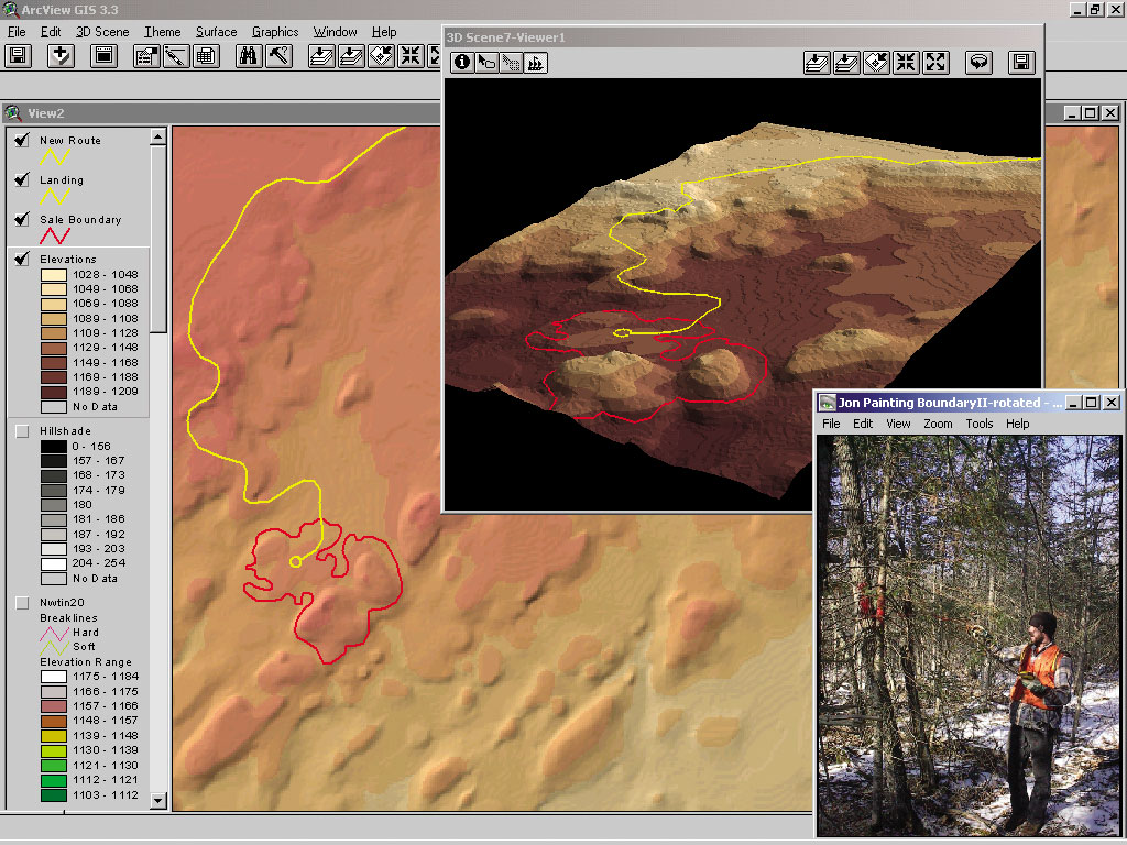
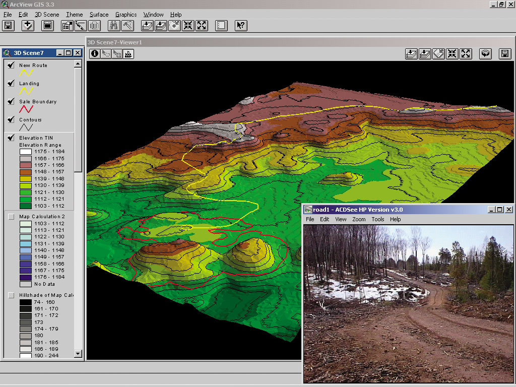
To find an appropriate solution, Douglas County turned to the Wisconsin Department of Natural Resources (WI DNR). Created in 1999 by the WI DNR Bureau of Forestry, a fully integrated forest recon management tool code-named RAVE (Recon ArcView Editor) was implemented. The software was developed primarily in an ArcView 3.x environment around an Avenue script core. Statewide tabular forest recon data for both state and county forests resides in an Oracle database. Maps and reports are generated in ArcView and produced by Crystal Reports. RAVE provides users with tools for addressing fundamental forest inventory updating, harvest planning, silvicultural prescriptions, reforestation activities, and stand maintenance scheduling. The application runs locally at county and state forestry offices with locally stored data being continuously uploaded into the central Oracle server. "RAVE has become an essential tool in managing our day-to-day forest activities," says Jim Latvala, forester for Douglas County. "Its user-friendliness allows foresters to become more accountable for updating data and planning management activities." Striving for sustainable forest management, the instantaneous forest recon updating provided by RAVE allows for more accurate data to be incorporated into commercial timber growth models as well as annual allowable harvest calculations. With the responsibility of planning and managing approximately 3,500 acres of allowable cut and scheduling silvicultural prescriptions and reforestation activities over 269,850 acres, Douglas County has implemented a fully functional, user-friendly, integrated GIS. Forest Structure ManagementThe primary management activity performed by Douglas County forestry staff is the establishment of commercial timber sales. Stands of aspen, white birch, red oak, northern hardwoods, and jack pine are under intensive even-aged forest management practices. Historically, many of these species were overharvested in a short time period resulting in poor age-class distribution over the current landscape, leading to reduced horizontal structural diversity throughout the forest. A multistoried or structured landscape provides many benefits to wildlife, forest health, species composition, human aesthetics, and overall ecological diversity. By incorporating remotely sensed land cover and forest recon stand height data into an ArcView project utilizing the ArcView 3D Analyst extension, large blocks of undisturbed, mature timber with very little structural diversity are easily visually identified and prioritized for possible sale establishment locations. Compared to simple two-dimensional coverages, modeling horizontal forest structure in three dimensions has provided a much better visual graphic for foresters to use as a tool in planning management efforts as well as examining effects of past practices. Timber Sale Establishment Planning Process
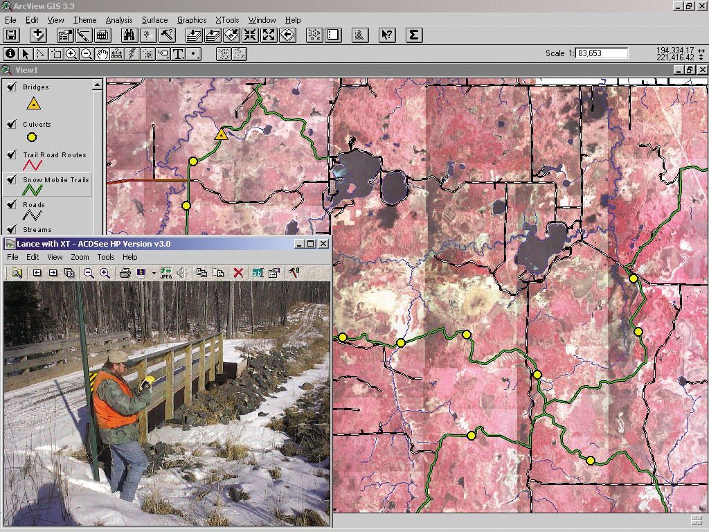
Timber sale establishment is the process of locating, analyzing, establishing, and preparing a particular stand of timber for harvesting. Traditionally, foresters relied on black-and-white 1:15,840 aerial photography and acetate film for hand-drawn maps to estimate locations, road routes, boundaries, and acreages of timber sale preparation activities. These estimates were often inaccurate and resulted in significant errors. Facing growing pressures from the logging industry and a drive for improved product quality, three Trimble GPS GeoExplorer III units were implemented in many phases of the field data collection activities. Area, line, and point features, such as boundaries, proposed road routes, parcel corners, and survey monuments, are recorded in the field and later incorporated into ArcView where topography, black-and-white/infrared digital orthophotos, and watershed hydrology coverages are used to further analyze timber sale establishment planning activities. United States Geological Survey 10-meter digital elevation models (DEMs) are imported into ArcView, and ArcView Spatial Analyst is used for topographical analysis such as calculating the total topographical surface area of specific forest stands, crucial to accurately estimating wood volumes. Subsequently, DEMs are viewed three-dimensionally with ArcView 3D Analyst, allowing for better planning and designing of sale boundaries and new timber access road routes. Managing Recreational ResourcesFaced with the challenge of developing and maintaining 300 miles of snowmobile and seasonal all terrain vehicle trails, 17 miles of cross-country ski trails, and numerous nature-hiking trails, Douglas County once again turned to GIS for a solution to more efficiently and effectively manage complex trail maintenance and monitoring data. Mapping the countywide trail system was accomplished with GPS technology where ArcView software's geoprocessing and feature editing tools were used for further analysis and manipulation of data. Attributes, such as trail names, types, permitted uses, seasonal designations, and property owners, were attached to trail features. In addition to simplifying logistics, the use of ArcView by recreational staff has proved itself a real time-saver in scheduling, mapping, and monitoring general maintenance activities such as trail grading and grooming. Recently, the department has continued to streamline and expand this program by implementing Esri's ArcPad, a mobile GIS on a Trimble GeoXT GPS platform incorporating trail gate, culvert, and bridge monitoring data. For more information, contact Jon Harris, GIS specialist/forester, Douglas County Forestry Department, Solon Springs, Wisconsin (tel.: 715-378-2219, e-mail: jharris@douglascountywi.org). |