Summer 2003
Summer 2003 |
|||||||
|
|
|||||||
Geospatial One-Stop Portal Is Key to President's E-Government Strategy |
|||
|
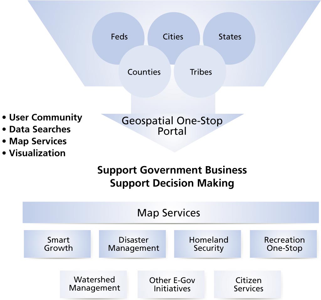
This statement from a Presidential memo documents the Bush administration's commitment to technology. This is further detailed in the E-Government Act signed by President George W. Bush in 2002, which calls for expanding the use of the Internet and computer resources to deliver government services for a citizen-centered, results-oriented, and market-based government. To achieve these goals the Office of Management and Budget is overseeing 24 e-government initiatives. The Geospatial One-Stop Initiative is one of these 24 initiatives. The purpose of Geospatial One-Stop is twofold. The first purpose is to support the business of government. Almost every aspect of government, including, but not limited to, disaster management, recreation, planning, homeland security, public health, and environmental protection, has a geographic component and requires geospatial data and tools to appropriately manage it. The second purpose is to support decision making—issues occur in places (e.g., floods, events, crimes) and decisions addressing one issue often have broader implications, sometimes affecting entire communities. Geospatial information allows decisions to be viewed in a community context and can facilitate cross-agency coordination.
Geospatial One-Stop builds on investments already made to develop a National Spatial Data Infrastructure (NSDI) and capitalizes on advances in geospatial information technologies to encourage greater collaboration and coordination in their use across all levels of government. The Geospatial One-Stop Initiative has several components, but the most visible is the development of a portal to make it easier, faster, and less expensive for all levels of government and the public to access geospatial information. Geospatial One-Stop Portal VisionHomeland security and other critical e-government initiatives depend on quick and easy access to geospatial data. To meet this urgent need the federal government determined that it needed to deliver a sustainable, interoperable portal. And it had to do this quickly. First, the Geospatial One-Stop team defined a vision for the portal. The Geospatial One-Stop portal would be the Internet-based organizational umbrella for federal agency channels addressing geospatial activities. The portal would be the virtual repository for spatial data and Web services to support local, state, and federal programs and decision making. The portal would be the gateway to find
What Is the Geospatial One-Stop Portal?In order to deliver a fully functional portal in a matter of weeks, the Geospatial One-Stop team is working with Esri to leverage the portal development work already being done for the Bureau of Land Management (BLM) for the National Integrated Land System (NILS) project and the Geography Network. The NILS GeoCommunicator portal provided a perfect time- and money-saving jump-start for developing the Geospatial One-Stop portal. As a result, Esri was tasked with quickly creating this portal, using past experience and standards-based commercial off-the-shelf technology. Additionally, the Geospatial One-Stop portal would be open and interoperable and would incorporate industry-approved interoperable standards. In June 2003, Esri delivered the Geospatial One-Stop portal to the government. The portal is the one-stop Web utility that provides the ability to search for geospatial data, Web mapping services, data collection activities, references, and contact information about GIS professionals at a national scale through the Geospatial One-Stop network. Geospatial One-Stop portal users are now able to
Geospatial One-Stop Builds a GIS for the NationThe Geospatial One-Stop program is the foundation for building a GIS for the nation: a realization of the National Spatial Data Infrastructure. The Geospatial One-Stop program is responding to a variety of federal business drivers demanding better service to citizens, more collaboration, improved efficiency, and improved homeland security. The entire GIS user community is encouraged to participate in the Geospatial One-Stop. To start, go to geodata.gov to register your geospatial data and Web services. For more information, contact Pat Cummens, Esri (tel.: 651-454-0600, e-mail: pcummens@esri.com). Also see Innovations Key to Geospatial One-Stop Portal Design. |
 "Implementation of e-government is important in making government more responsive and cost-effective."