Summer 2003
Summer 2003 |
|||||||
|
|
|||||||
Dane County, Wisconsin
Land Use Impacts for the Black Earth Creek Watershed Modeled With GIS |
|||||||||||
|
By Tom McClintock, University of Wisconsin-Madison, and Larry Cutforth, Dane County Regional Planning Commission
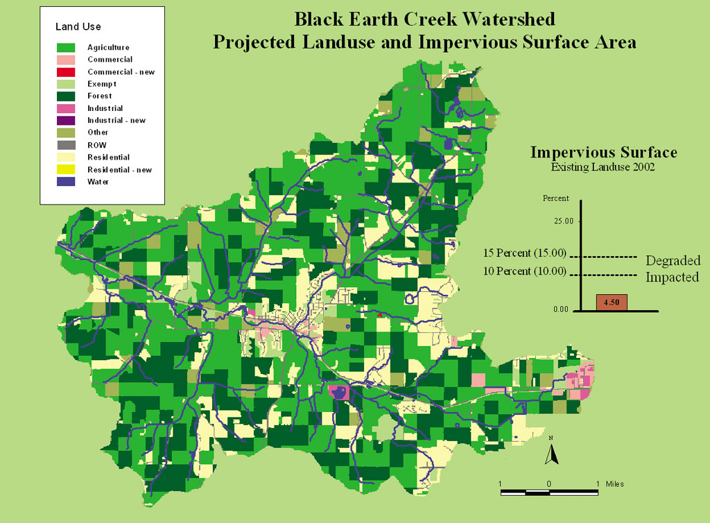
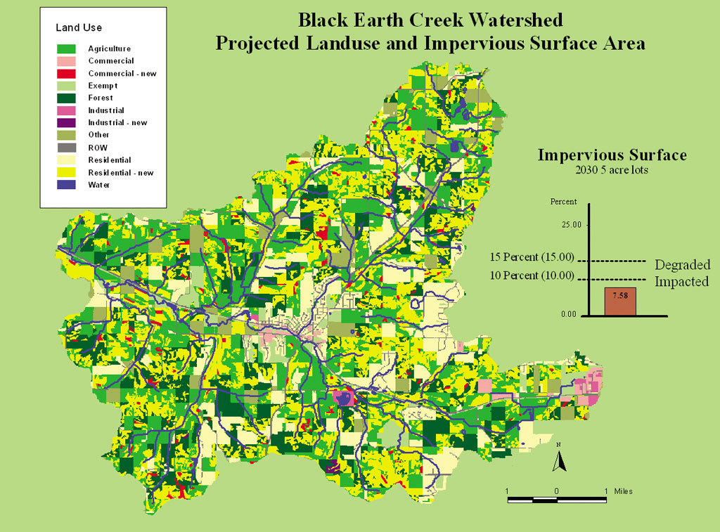
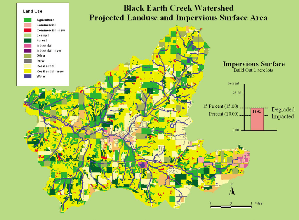
Balancing growth and preservation is a pervasive challenge for planners and resource managers everywhere. The Black Earth Creek watershed in Dane County, Wisconsin, demonstrates the tensions of balancing multiple land use objectives: protecting a valuable cold water stream, sustaining agriculture, and accommodating new development. It also demonstrates the role that Esri software and GIS-based tools, such as What if? and CommunityViz, can play in dealing with these issues. Environmental Dangers in Black Earth CreekBlack Earth Creek is a naturally reproducing brown trout fishery that supports up to 1,600 wild trout per stream mile and has been designated Outstanding and Exceptional Resource Waters by the Wisconsin Department of Natural Resources (WDNR). Over the past 15 years, $4 million has been invested in the area on resource management tools such as dairy manure storage pits, conservation easements, and trout habitat improvements. The Black Earth Creek watershed is located within a 15-minute drive of the city of Madison, with a metropolitan population of 350,000 people. Besides the close proximity to Madison, the watershed's pastoral glacial valleys and panoramic ridge tops attract a variety of homeowners. As dairy herds and suburban development expand into the watershed, the sustainability of the Black Earth Creek fishery has become increasingly threatened. The land use tensions among the Black Earth Creek fishery, agriculture, and development reached a crisis in June 2001 when a two-inch rainfall resulted in a widespread trout fish kill in Black Earth Creek. In some segments of Black Earth Creek 80 percent of the trout population was killed, and WDNR fish biologists estimated that it would take three years for the fishery to recover its previous fish populations and sizes. WDNR concluded that a variety of diffuse sources were likely responsible for the fish kill: farmers' manure spreading near the creek, farm pesticides discharged into the creek through drainage tiles, and urban storm water runoff from impervious surfaces. Using GIS to Examine the IssueResponding to the fish kill, the University of Wisconsin-Madison Land Information and Computer Graphics Facility (LICGF) decided to examine the use of GIS modeling and impact assessment tools to consider how urban growth might impact Black Earth Creek in the future. The LICGF has a 25-year history of helping local governments and agencies adopt GIS for land use and natural resource applications through partnerships, demonstration projects, and hands-on education and training. The LICGF researchers modeled the growth of impervious surface areas under different development scenarios because the quantity of impervious surfaces directly affects stream quality and is more readily quantifiable than some of the other factors affecting a stream's health. As the Black Earth Creek watershed develops and roofs, roads, and other impervious surfaces cover more of the earth's surface, less water can infiltrate into the ground; more runoff at higher temperatures will discharge into the creek, thereby threatening its fish population. A generally accepted rule of thumb is that stream health begins to decline when the surface reaches 10 percent imperviousness and becomes severely degraded when imperviousness exceeds 30 percent. The researchers began by using a digital elevation model (DEM) and the ArcView Spatial Analyst Hydrological Modeling extension to determine the watershed that contributed runoff to the stream. The watershed was determined to be about 28,954 acres or about 45 square miles in size and included several political jurisdictions. Forecasting Future Land Use Patterns and Their EffectsNext, the LICGF researchers used the What if? package developed by Esri Business Partner What if?, Inc. (Hudson, Ohio), to prepare alternative scenarios for the future development of the Black Earth Creek watershed. Available information on slopes, distance to roads and existing development, productive farm soils, distance to streams, and wetlands was combined in ArcView to create a comprehensive view of the region's environmental resources. This information was used in What if? 1.1 to determine the relative suitability of different locations for accommodating future development. Information from the U.S. Census of Population was used to prepare scenarios for the area's likely population in 2010, 2020, and 2030. What if? was then used to project future land use patterns for different development densities. The projected addition of 1,358 households for 2030 required 450 acres of land for quarter-acre lots; 1,700 acres for one-acre lots; and roughly 8,000 acres for five-acre lots. The projected land use maps under the different growth scenarios were saved as ArcView shapefiles for use in later stages of the analysis. The amount of impervious surface associated with different development patterns was estimated from locally derived impervious surface coefficients. Impervious surfaces in the form of roads, roofs, driveways, and gravel pits were digitized from one-foot orthophotography using ArcView 3.x. The impervious surfaces were combined with a digital parcel layer to calculate an average percent imperviousness for different lot sizes and land uses. Five-acre residential lots had an average of 8 percent impervious surfaces; one-acre residential lots had an impervious coefficient of 16 percent; and quarter-acre residential lots had a coefficient of 26 percent. The impervious surface coefficients for commercial lots, industrial lots, and rights-of-way were 40 percent, 50 percent, and 80 percent, respectively. The CommunityViz Scenario Constructor, developed by The Orton Family Foundation (Boulder, Colorado), another Esri Business Partner, was used to develop indicators measuring the effects that different development scenarios would have on overall stream quality. The derived impervious coefficients for different land use types were used as variables in a Scenario Constructor formula to estimate the overall percentages of impervious surface for different land use patterns. The What if? land use forecasts were brought into Scenario Constructor, which was then used to compute the overall percentage of impervious surfaces, which was displayed on-screen as a chart. The watershed's existing development was found to have roughly 4.5 percent impervious surfaces. The projected land use patterns for 2030 with quarter-acre lots yielded an average of 5.8 percent impervious surfaces; development patterns for one-acre lots yielded an average of 6.7 percent impervious surfaces; and five-acre lots had an average of 7.6 percent impervious area. None of these scenarios significantly endangered the stream. However, scenarios that considered what would happen if all the available land was developed indicated that a development with five-acre lots would yield an average of 9 percent total impervious area; one-acre lots would yield 14.6 percent impervious surfaces; and quarter-acre lots would produce a 20.6 percent impervious area. In the short term, higher-density development would have a smaller impact on the watershed. However, assuming that 10 percent imperviousness is the threshold for maintaining a sustainable trout fishery, all three build-out scenarios suggest trouble ahead if current development trends continue without mitigation. Policy ImplicationsThe results of this GIS-based analysis provide an incentive for implementing policies to minimize the effects of future development on the Black Earth Creek fishery. Dane County recently enacted Wisconsin's first storm water performance standards for new developments. These standards require storm water runoff from roads and other impervious surfaces to be allowed to infiltrate into the ground instead of being diverted to storm drains. The St. Francis subdivision in the Black Earth Creek watershed is one of the first subdivisions to incorporate these infiltration practices. Every home in the subdivision is required by deed restriction to plant a rain garden of native grasses to help infiltrate runoff water. In addition, roads in the subdivision have a boulevard median strip to help capture road runoff. This example illustrates the role that Esri's GIS software and related tools such as What if? and CommunityViz can play to help public officials and private citizens understand the environmental implications of future development. Together they can help provide a foundation for informed actions that can help protect critical natural resources such as the Black Earth Creek fishery. For more information, contact Tom McClintock, University of Wisconsin-Madison Land Information and Computer Graphics Facility (tel.: 608-263-5534, e-mail: tlmcclin@wisc.edu, Web: www.lic.wisc.edu). For more information about What if?, contact Richard E. Klosterman, president, What if?, Inc. (tel.: 330-650-9087, e-mail: klosterman@What-if-PSS.com, Web: www.What-if-PSS.com). For more information about Scenario Constructor, contact CommunityViz (tel.: 866-953-1400), e-mail: info@communityviz.com, Web: www.communityviz.com). |
|||||||||||