Summer 2003
Summer 2003 |
|||||||
|
|
|||||||
Interoperability Extension for ArcExplorer—Java Edition Also Available
New Versions of ArcExplorer Now Available |
|||
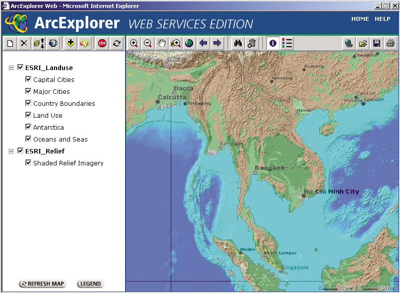
Two new versions of ArcExplorer are now available: ArcExplorer Web and ArcExplorer 4.0.1—Java Edition. ArcExplorer WebArcExplorer Web, an online geographic data viewer, provides a fast, simple way to view multiple map services in a standard Web browser. With ArcExplorer Web, you can add map services from the Geography Network and other ArcIMS servers and display them in a single map view. You can also set the transparency of each map service, save your map, and create a link to it from your Web page. No downloads, plug-ins, or applications are necessary to use the viewer; simply visit the ArcExplorer Web product page and choose to launch ArcExplorer Web. Optionally, Esri can be engaged to give ArcExplorer Web the same look and feel as the rest of an organization's Web site. For information on this service, send e-mail inquiries to aewebteam@esri.com. ArcExplorer 4.0.1—Java EditionArcExplorer 4.0.1—Java Edition is a freely downloadable data viewer supported on Macintosh and SGI-IRIX operating systems in addition to continued support on AIX, HP-UX, Linux, Solaris, and Windows. The ArcExplorer 4.0.1 download is available from www.esri.com/arcexplorer. Also, as described below, the new interoperability extension for ArcExplorer is supported with version 4.0.1. Interoperability Extension for ArcExplorer—Java EditionThe new interoperability extension for ArcExplorer 4.0.1—Java Edition, which adds support for OpenGIS Web Map Services (WMS) and Web Feature Services (WFS), is now available. The interoperability extension for ArcExplorer 4.0.1—Java Edition acts as a client for WMS- and WFS-based servers. With the interoperability extension, ArcExplorer—Java Edition can write out any feature layer as a Geography Markup Language (GML) document and add those GML documents to its view. GML is an OpenGIS Implementation Specification designed to transport and store geographic information. The interoperability extension for ArcExplorer is available at no cost from the Esri Interoperability Technology Download Center. Also available at the download center are the WMS and WFS connectors for ArcIMS. Spatial data standards and interoperability have long been a major focus for Esri. Esri has developed its products based on open standards to ensure a high level of interoperability across platforms, databases, development languages, and applications. Esri is also committed to supporting and actively leading efforts associated with interoperability and the development of standards. For more information on Esri's dedication to data standards and GIS interoperability, visit www.esri.com/standards. |