Summer 2003
Summer 2003 |
|||||||
|
|
|||||||
Orlando, Florida, Utilities Commission Powers Water and Electric Services With GIS |
|||||
|
Serving the electric and water needs of much of the Orlando area is the Orlando Utilities Commission (OUC). OUC is the second largest municipal utility in Florida and the 16th largest in the nation, with more than 190,000 customers in the cities of Orlando and St. Cloud and adjoining portions of Orange and Osceola Counties in central Florida. At OUC, providing dependable service to its customers is its first priority. To maintain its position of reliability in the state, OUC invests in good equipment, preventative maintenance, and—above all—its dedicated employees. When a service interruption does occur, OUC crews respond quickly to restore electric and water services.
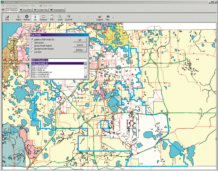
Reliability is also of critical importance to OUC when it comes to information technology (IT) systems. Systems such as facilities management and outage management play key roles in the utility's daily operations. "Maintaining the electric model for our outage management system is mission critical," says Ken Zambito, manager of Finance and Technology in OUC's Energy Delivery Business Unit. "We also needed a more efficient and accurate way to maintain and distribute important geospatial data to our water and electric field crews and engineers." With that in mind, OUC set out to create a business case to capture its needs and identify the best possible technology. After conducting in-depth research, OUC selected Esri to provide an enterprise GIS solution. OUC Creates Business Arguments for GISTo better support its utility operations and reduce duplicate operating costs, OUC needed to explore ways of streamlining its business and data management processes. The utility started by researching GIS technologies and companies that could help in implementing a companywide platform for automating and simplifying its operations. "We needed an enterprise, or foundation, geographical information system that would accurately represent our water and electric distribution systems and provide a geodatabase that could be efficiently updated and managed," says Rick Coleman, OUC's director of Water Engineering and Executive GIS project sponsor. "Also, the GIS had to be a useful and reliable tool for operations, engineering, and other groups within OUC, as well as for customers, and be capable of being integrated with other systems in the future." OUC concluded that a foundation GIS would help the utility produce more accurate and up-to-date maps in support of its daily operations. Additionally, OUC anticipated a foundation GIS solution would help its crews respond faster to customer requests, help the utility receive and share data with other agencies, and make its overall performance even more reliable. Also the foundation GIS solution would help
Based on these findings, "OUC felt that Esri's technology provided the most flexible and expandable solution to meet OUC's short-term as well as long-range GIS requirements," says Rick Frymyer, OUC's Electric GIS project manager. Esri's solution gave OUC the tools it needed to begin developing cost-saving business and data management processes. It was also the foundation of a partnership that capitalized on the unique skills and experience of both OUC and the Esri team. OUC Builds a Partnership for SuccessIn addition to using Esri technology, OUC partnered with Esri Professional Services to implement this foundation GIS solution for its electric and water business units. Esri teamed with two subcontractors-Esri Business Partners Miner & Miner (Fort Collins, Colorado) for technical consulting and M.J. Harden (Kansas City, Missouri) for data migration services. OUC made it clear that Esri had to enter a long-term partnership with OUC in order for this project to be successful. "Our CEO is a strong advocate of partnering with consultants to create mutual ownership of a project," says Ron Hawkins, OUC's Water GIS project manager. "Esri seized this opportunity to deliver a quality implementation process and product." After two years, the foundation GIS implementation and data conversion at OUC are complete. Esri's long-term partnership agreement to support OUC has been extended for three additional years to support and maintain the project and to work closely with OUC in setting up future phases of the GIS. OUC's foundation GIS allows users to
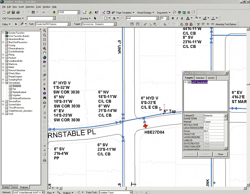
The implementation of the foundation GIS was structured into eight phases: project planning, system and hardware architecture and deployment, GIS software deployment, data modeling and functional analysis, database conversion and migration (including basemap acquisition, field data collection, migration specifications, quality control, data conversion tools, a pilot data conversion, and a full-scale conversion of water and electric data), GIS application and interface development, training and resource development, and ongoing system maintenance and operation. With the conclusion of this initial foundation GIS implementation, OUC was able to bring all of its source information into a single geodatabase that OUC maintains using Esri and M&M ArcFM technology. Besides simplifying data maintenance, the geodatabase has improved communication and sharing of geospatial information within OUC and between OUC and several local and state agencies. For more information, contact Ron Hawkins (Water) (e-mail: rhawkins@ouc.com) or Rick Frymyer (Electric) (e-mail: rfrymyer@ouc.com), OUC (tel.: 407-423-9100), or Lane Powell, Esri project manager (e-mail: lpowell@esri.com; tel.: 909-793-2853, ext. 1-1551). |
 Orlando, Florida, is one of the world's premier travel destinations. Home to SeaWorld, Universal Studios, and Walt Disney World, this fast-growing area hosts more than 35 million visitors each year.