Summer 2003
Summer 2003 |
|||||||
|
|
|||||||
South Carolina Telecommunications Firm Implements GIS |
|||
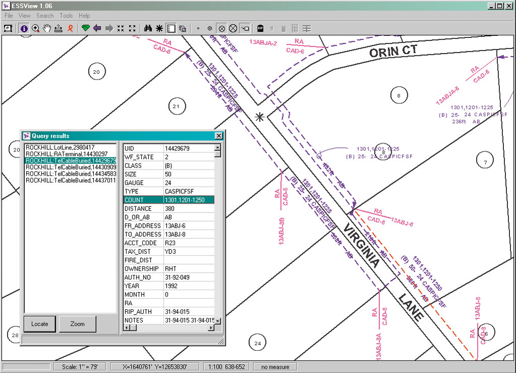
The U.S. telephone service and cable television industries received a major overhaul in 1996 when Congress passed the Telecommunications Act. According to the Federal Communications Commission (FCC), the goal of this law was "to let anyone enter any communications business—to let any communications business compete in any market against any other." In this new era of competition, telecommunications firms small and large have been looking for ways to stand out in terms of service and dependability. For long-established companies, part of staying competitive is keeping up with the latest technology. For instance, Comporium Communications of Rock Hill, South Carolina, is in the process of substantially upgrading how it keeps track of its miles and miles of cable. Comporium is a group of affiliated companies providing residents of the north-central South Carolina counties of Lancaster and York with communication services including local telephone, long distance, wireless, cable TV, and Internet connection. Just over the border from fast-growing Charlotte, North Carolina, the area is becoming less rural and more suburban. "We've just completed the first step in converting from a CAD-based system to a GIS, and we're already seeing the benefits," says Worth Sparks, assistant manager, Engineering Support Services at Comporium. Sparks is also a C++ programmer and Comporium's GIS expert. "Our CAD program was a proprietary file system and was tied to a single PC. Every database was single user," explains Sparks. "To make changes to it you might have to export a section, make the changes, and then remerge the data. It also was difficult to find things because the search routine was antiquated. Even panning and zooming were difficult." About two years ago Comporium decided that it needed to upgrade to a GIS. "The first thing that piqued our interest in Esri was ArcSDE," continues Sparks. "We found ArcSDE to be a very open platform. We wanted our spatial data to be free to move from one vendor's database to another and ArcSDE provides this. Once Esri had our attention, we began to realize some of the possibilities in its other software offerings. Ultimately, we chose Esri because of its wide selection of options and the promise of an exciting future." Comporium's migration from its legacy system did not happen overnight. Rather, it took a more gradual approach to implementing what will eventually be an enterprisewide GIS implementation with dozens of end users. "Our first step, which we've just recently completed, was to get the data converted with a viewer platform," says Sparks. "That viewer is MapObjects. We now have about 70 users of the MapObjects application with access to a read-only version of the data." According to Sparks, MapObjects gave them full control of their application that the CAD system did not offer. "If there is any new feature that anyone wants, we can simply add it. The application has anything the telephone industry needs. "I've made the system extremely simple to use. There's a toolbar across the top that gives technicians all they need but nothing more. I've even created a dialog that resembles the tool they used previously, so the transition for these users was very easy." One of the most important uses of the MapObjects application is to locate cable in the field. Technicians will routinely download the most up-to-date data and take a laptop out to the field with them. "I get comments every day about how this has saved them time," says Sparks. "If a customer calls in complaining of a noisy line or slow modem connection speeds, we run a 'loop makeup' to help track down the problem. Before, a technician might be clear across the county and have to call back here to have us run a cable trace and try to describe it to him over the phone. But if he has downloaded the data onto his laptop, he can run the cable trace there and view it right on his screen." With its data converted to shapefile format, Comporium is ready to further enhance its system's functionality throughout 2003. The conversion to an enterprise system using ArcGIS is already in the works. For Comporium, ArcSDE is the future key to enterprise data management. "2003 will be the year of the geodatabase for us," continues Sparks, referring to the ArcGIS data storage format. "We have already begun to build our geodatabase. The plan is to initially convert our data maintenance users to our newly formed geodatabase and to ArcInfo desktops by summer 2004. Shortly after, we will produce a new version of our MapObjects software-based viewer to connect to the geodatabase." For more information, contact Worth Sparks at 803-326-7231, e-mail worth.sparks@comporium.com, or visit www.comporium.com. |