Summer 2003
Summer 2003 |
|||||||
|
|
|||||||
MetroGIS Deploys Data Distribution System
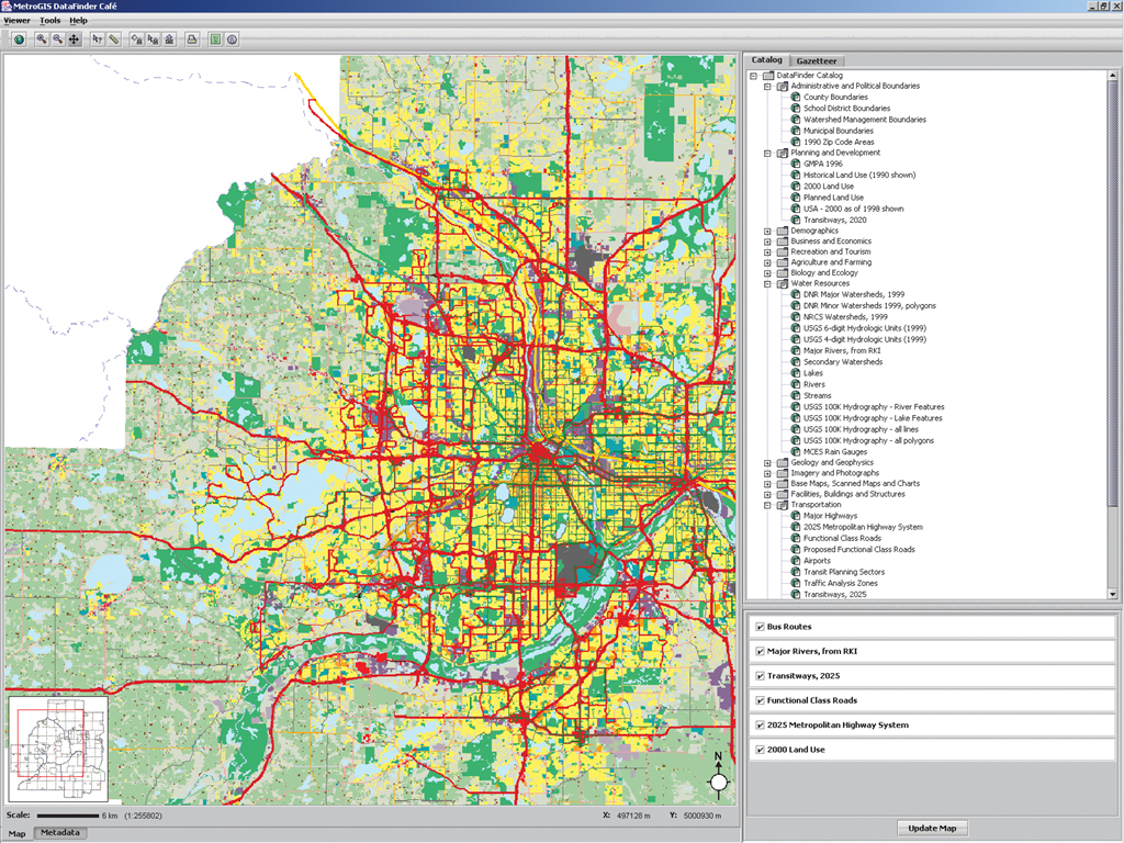
The Seven-County Minnesota Twin Cities Metropolitan Area Creates a Central GIS Repository |
|||
The decision makers at MetroGIS, an innovative GIS initiative serving the seven-county Minneapolis–St. Paul, Minnesota, metropolitan area, had come to the conclusion that distributing very large GIS data files via CD–ROM would be both costly and burdensome. MetroGIS' mission is to provide a regional forum to promote and facilitate widespread sharing of geospatial data. A voluntary collaboration of more than 300 local and regional governments, MetroGIS also has participants from state and federal governments, academia, and commercial and not-for-profit arenas. The recipient of the 2002 URISA Exemplary Systems in Government (ESIG) Award for Enterprise Systems, the organization's roots date back to the mid-90s. Conceived in 1995 by the Metropolitan Council, the planning agency that serves the seven-county Twin Cities Metropolitan Area, the impetus was to institutionalize data sharing so its stakeholders could easily obtain accurate and reliable data in the form needed to carry out their business functions. With strong public support the council officially moved to sponsor the MetroGIS initiative. Within a year, MetroGIS had a mission statement and identified five initial strategic initiatives including the implementation of an Internet-based data search and retrieval tool. A Vision for Data DistributionAlthough MetroGIS already had a substantial online GIS presence, the organization instituted a competitive bid, with an important differentiator being an Open GIS Consortium (OGC)-compliant solution. At the end of the process, MetroGIS approached Esri Business Partner Syncline, Inc. (Boston, Massachusetts), for help with the design, development, and deployment of a sophisticated GIS data distribution system. Participants of the organization envisioned an automated, online system whereby MetroGIS members and anonymous browsers alike could locate GIS data of interest via an intuitive, map-based application and then download only the geographic extent of interest rather than the complete data set. An overriding design objective was to create a distributed system such that partners would be able to distribute their own data from their own servers. Stringent security requirements demanded that access to data be restricted according to the user's organization and that person's role within that organization. In addition, the vision called for cross-platform compatibility, compliance with the open standards developed by the Open GIS Consortium, and a strong focus on an easy-to-understand user interface. ArcIMS Software-Based Web Services Play Integral Role in DataFinder Caf�Given the nature of the requirements, a Web services model was deemed the best approach to fulfill the vision, and ArcIMS was chosen to be the basis for an associated e-commerce strategy. The new system, now known as MetroGIS DataFinder Caf�, has two distinct operators: a Web-based application (client) and a federation of loosely coupled servers working and communicating in concert to support that client. The nerve center for the federation is an ArcIMS server hosted by MetroGIS. It is here that image, feature, and data extraction requests are brokered among a group of servers managed by partners such as Minnesota's Land Management Information Center (LMIC) and the City of St. Paul. The nerve center intelligently combines image and feature layers on the fly, creating a composite map image that is sent to the Web client. This framework keeps control of the data (updates and access permissions) in the hands of the partner organization. Here, the dominant axiom is "data management is local—access is global." Alison Slaats, DataFinder Caf� manager, notes, "This is a very valuable part of what Syncline developed for us. It means that our partners can distribute data from their servers, which results in the ability to serve the latest data sets while, at the same time, reducing overhead costs." Another important aspect of the nerve center is that it can not only communicate with servers that are in disparate locations, but it can interface with different mapping technology as well. To accomplish this, the system implemented open OGC standards called Web Map Server (WMS) and Web Feature Server (WFS) Gazetteer, common XML-based protocols for exchanging map images and features. The MetroGIS server speaks to other servers in the federation utilizing WMS and WFS components that sit on top of ArcIMS. "To use our Web map server technology, our partners need only be compliant with OGC standards," says Slaats. On the back end, an easy-to-use administrative interface provides a means by which MetroGIS staff can customize the data taxonomy (in a hierarchical format of their design) and data access privileges. The security framework provides a facility by which end users see only the data to which the administrator provides them access. Advanced Data Download CapabilitiesThe DataFinder Caf� client uses cutting-edge Java Web Start technology to deliver a desktop application-like feel to the end user. The map-based interface employs easy-to-use tools to add data layers of interest to the map view, navigate around that view using standard mapping tools, zoom directly to a point of interest using the geocoder, and/or zoom directly to an extent of interest using the built-in gazetteer. Once the area of interest has been located, several extraction methods are available. Users can download data based on the current map extent by drawing an ad hoc polygon on the map or by selecting a feature of interest from one layer and performing a "cookie cutter" extract on one or more other layers and, optionally, using a buffer. An intuitive wizard steps the user through the entire process and even provides the end user with the ability to selectively turn on or off specific attributes for inclusion or omission in the delivered data set. The user can also select the data format for delivery from a number of industry-standard GIS and CAD formats including .shp, .dwg, and .tab. Ultimately the data is zipped and downloaded to the user's desktop for GIS use. DataFinder Caf� Takes OffThe system went live in June 2002 and already fulfills more than 100 extraction requests per month, eliminating the need for MetroGIS to distribute data via CD. In addition, the DataFinder Caf� significantly increased the download options for users, enabling the creation of truly custom download bundles. The expanded data download capability provided by the DataFinder Caf� is already reducing the time and effort spent by community members searching for, accessing, and manipulating GIS data prior to use. For more information, contact Matt Gentile, Syncline (e-mail: matt.gentile@syncline.com). |