Summer 2004
Summer 2004 |
|||||||
|
|
|||||||
Tracking SARS in China With GIS |
|||
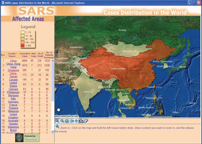
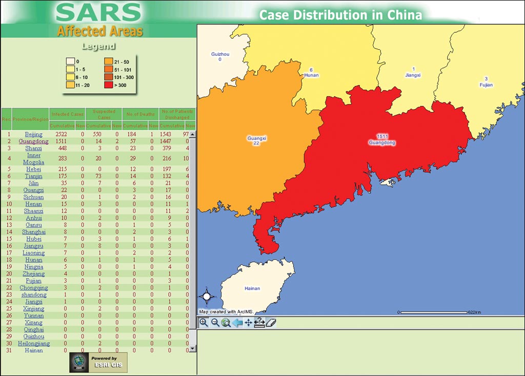
In late 2002, a new strain of atypical pneumonia was detected in southern China. By March 2003 the disease, now commonly known as Severe Acute Respiratory Syndrome (SARS), had spread around the world and would continue to cause suffering and widespread disruption for much of the next three months. The epidemic claimed the lives of many people, required the enforced quarantine of thousands more, and brought upheaval and discomfort to literally millions. It had severe economic implications for countries in Asia and leading cities around the world. As the World Health Organization (WHO), governments, and health authorities throughout the world battled to understand and contain the epidemic, the fear, confusion, and limited access to reliable information worked to compound an already difficult situation. It rapidly became clear that the disease spread through proximity with infected carriers, and isolation either of individuals or whole buildings became the single most effective response. The importance of location suddenly became very real to many people. Where were infected cases located? Which areas or buildings were free of the disease? More important, for speeding the return to normal life, which areas had been infected but were now declared clear? In Hong Kong, initially one of the hardest hit areas, Esri China (Hong Kong) Limited rapidly appreciated the value of GIS as a means of assembling and analyzing information on the spread and distribution of the disease. However, more than simply analyzing, Web-based GIS would make it possible to disseminate this information not only to the local population but to a global audience as well. As its contribution to a major effort by local businesses and community groups to respond positively to the emergency, Esri China (Hong Kong) developed and hosted the SARS Mapping Web site.
The Hong Kong SARS map page presented information on suspected, actual, and recovered SARS cases within Hong Kong. As part of its effort to provide clear, transparent data on the disease, DoH provided detailed information including a daily SARS bulletin, numbers and the status of patients, and the names of buildings in which infection had occurred. Every morning the SARS map team used DoH updates to geocode case information against Hong Kong street and building databases. This turned what had been tables of building names and statistics into data that could be intuitively presented, analyzed, and understood as a local map. Residents and visitors to Hong Kong could, therefore, easily check on the Web site which buildings in their neighborhoods had, or were suspected as having, infected cases and which had been cleared. Being able to see the information clearly presented on a familiar map helped alleviate a lot of the fear and concern of "not knowing" that had so disrupted normal life during the early days of the outbreak. The system also provided tools to highlight the most recent updates so people could monitor the spread of the disease and pace of recovery, as well as functionality to measure the distance between two buildings and check the number of infected cases within a given radius. In addition, the site provided summary views of statistics aggregated to administration regions. The China and world SARS map pages were based on daily status reports from the China CDC and WHO. Information presented included the number of infected, suspected, and recovered cases as well as the number of deaths. Information for the China SARS map was aggregated to regional boundaries, while that for the world map was summarized by countries providing a global overview of the distribution of the disease. The system, launched within a week of the outbreak occurring in Hong Kong, quickly became established as a center of information for both the public and press in the Asian region and throughout the world. At the height of the epidemic, the site was producing approximately 12,000 maps per day, and over the entire duration of the crisis produced more than 250,000 maps. Dr. Heston Kwong, principal medical and health officer, DoH, comments, "Getting accurate information to the general public about the nature and spread of disease was absolutely essential. We posted daily status updates on our home page. We were delighted to see this data being presented through the SARS Mapping Web site. Being able to see the distribution of cases on the background of a familiar map and run spatial queries on the data provided another excellent channel through which information could be passed to the public." The threat of SARS has, at least for now, subsided. On June 23, 2003, WHO removed Hong Kong from its list of areas affected by local transmission of the disease, and by the end of July 2003 all countries that had experienced the disease had been taken from this list. Many lessons have been learned in combating this disease including the importance of vigilance; clear and early notification of outbreaks; and accurate, open dissemination of information. It is also a reminder of the interconnected nature of today's world and the overriding importance of geography and location. The SARS Mapping Web site was developed as part of the Esri China (Hong Kong) ongoing program of serving the local community through the innovative deployment of GIS. The site was established and hosted as a voluntary initiative. Once the epidemic was over, the site was taken offline in August 2003. While it is hoped there will be no call to reactivate it, the site is ready if the need arises. For more information, contact Paul Tsui, sales and marketing director, Esri China (Hong Kong) (tel.: 852-2730-6883, e-mail: ptsui@esrichina-hk.com). |