Summer 2004
Summer 2004 |
|||||||
|
|
|||||||
U.S. Air Force Uses GIS to Predict Bird Strike Hazards |
|||||
|
At an August 1911 contest in Chicago, Illinois, Rodgers set an endurance record, remaining airborne for 27 hours over nine days. The next month, he set out to become the first person to fly across the United States. Leaving Long Island, New York, in a Wright Brothers biplane, he arrived battered and bruised in Pasadena, California, 50 days later, his plane comprising mostly replacement parts. He had landed for refueling and maintenance 68 times, including 16 crash landings.
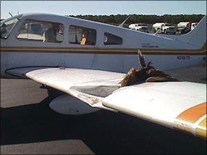
Rodgers was responsible for another important first the following April. Flying offshore near Long Beach, California, he encountered a flock of seagulls. One struck the aircraft and interfered with his controls, causing him to crash into the sea. The incident is considered the first documented bird–aircraft strike fatality in aviation history. The problem of sharing the skies with our feathered friends has not decreased as a result of technology. In fact, the opposite is true. As planes fly faster with quieter engines, bird encounters are likely. "There are approximately 3,000 bird strikes every year at an average annual cost of $45 million in the U.S. Air Force alone," says Dr. Russell DeFusco, a retired Air Force lieutenant colonel and former biology professor who has been working on the problem of bird–aircraft strikes for years. DeFusco is currently a consultant to the U.S. Air Force (USAF) on bird strike hazards. He adds, "Worse than that, we have had 33 fatalities since 1985. The military is particularly susceptible to bird strikes because we train at high speeds and low altitudes. Our aircraft are vulnerable because they are often smaller and have fewer backup engines than large airliners." Since World War II, the Air Force has concentrated on mitigating the problem around airfields because the risks are greatest at takeoff and landing. Over the years, many practices have been developed to reduce the number of birds around runways, including the use of scarecrows, falconry, and pyrotechnic "popper" cannons to scare them. "The goal is to avoid creating a nice, cozy nesting environment on and around the airfield," says Ed Riegelmann, a vice president at Esri Business Partner CH2M HILL. Headquartered in Denver, Colorado, CH2M HILL is an employee-owned, global firm providing engineering, construction, operations, and related technical services to public and private clients, including the Air Force. "Early bird–aircraft strike evaluations were done for each airfield, applying a statistical approach for that location at that time. It was a lessons learned approach. It was crude, and there was no geography involved."
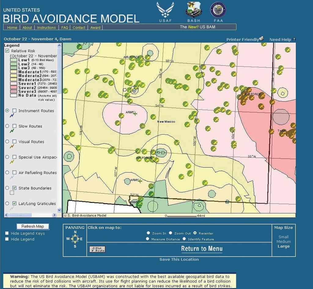
According to the U.S. Air Force Bird/Wildlife Aircraft Strike Hazard (BASH) Team, efforts to digitally model bird strike risks began in the early 1980s. "The initial Bird Avoidance Models developed beginning in 1982 were manual in nature," says DeFusco. "As part of an Air Force sponsored doctoral program, I later developed a GIS-based model using Geographic Resource Analysis Support System (GRASS) software developed by the U.S. Army. A larger GIS-based version of this model was later developed under contract with another firm, also using GRASS." However, a significant event prompted the Air Force to redouble its efforts. On September 22, 1995, an E-3 Airborne Warning and Control System plane, a high-tech radar surveillance platform based on the Boeing 707, crashed on takeoff from Elmendorf Air Force Base in Alaska, igniting 125,000 pounds of jet fuel. Its crew of 22 Americans and two Canadians was killed. Several dead Canada geese were found on the runway, and others were believed to have been sucked into the jet intakes causing the engines to fail. "Two factors converged at that time," explains Riegelmann. "We had this tragic event at a time when significant research was being done in the academic community using GIS to model point phenomena. We believed we could create an interpolated model from point data over a landscape. Biologists picked up on the concept quickly and wanted to apply it." For their GIS work on the U.S. Bird Avoidance Model (BAM), the GIS developers for the BASH Team selected ArcView 3 and the ArcView Spatial Analyst extension. "We were looking for a certain capability," adds Riegelmann. "We knew we had discrete point data we needed to interpolate over the United States. We realized we were going to have issues statistically evaluating the data. We had varying densities of point data, so we needed some good analytical tools. We felt that ArcView Spatial Analyst was the best choice, built on the vector data support from other Esri products." The current BAM research effort is seated at the Institute for Information Technology Applications (IITA) at the U.S. Air Force Academy, Colorado Springs, Colorado. Funding for the project is provided by the BASH team, part of the Air Force Safety Center, Kirtland Air Force Base, New Mexico. BAM is a predictive bird hazard model that consists of 104 time period-based GIS raster grids that cover the continental United States. The value of each cell, or pixel, in one raster grid is equivalent to the sum of the mean bird mass for all species present during a particular daily time period for one of 26 two-week periods per year. Bird weight and distribution were derived from a variety of sources including 30 years of North American Breeding Bird Survey and Audubon Christmas Bird Count data sets as well as reported bird strikes recorded in the USAF and Federal Aviation Administration databases for the past 20 years. Arrival and departure dates of bird species acquired from refuge managers nationwide are factored in as well as data from the U.S. Fish and Wildlife Service, among others. "We collect any kind of data we can think of from any source we can think of," says Kristie Sweeney, a CH2M HILL GIS analyst working for IITA. "Locations of landfills and vegetative cover data tell us which areas are attractive to birds, as well as atmospheric data and topographic data—modeling bird behavior is pretty complex." Using ArcView with ArcView Spatial Analyst, the statistical method used to generate the interpolated raster surfaces from species point data was an inverse distance weighted method, a technique that determines cell values in a grid with a set of weighted samples. The farther a point is from the cell being evaluated, the less important it is in calculating the cell's value. The team currently uses ArcView 8.x with the ArcGIS Spatial Analyst and ArcGIS Geostatistical Analyst extensions to develop and maintain the data. Military and civilian pilots can access the model at a publicly accessible Web site (www.usahas.com/bam), which was developed with ArcIMS. "The idea is for the flight planner to sit down ahead of time and determine relative risk," says Sweeney. "The Avian Hazard Advisory System (AHAS) incorporates BAM historical data and updates it with radar weather information, so it's near real-time risk." "Right now Air Force flight crews are instructed to access BAM and AHAS to look at their predictive risk," adds Riegelmann. "It's a preflight checklist item. So it has become institutionalized in the business process of flight operations." As long as birds and aircraft share the skies, there will be collisions. It is difficult to quantify how many incidents have been avoided by flight planning using the model. However, some users state they've seen up to a 70 percent reduction in damaging bird strikes, saving potentially tens of millions of dollars and, doubtlessly, lives. For more information, contact Kristie Sweeney, IITA (tel.: 719-333-9286, e-mail: Kristie.Sweeney@usafa.af.mil). |
 Perhaps less famous than other pioneering aviators, such as Eddie Rickenbacker or Charles Lindbergh, Cal Rodgers is responsible for several "firsts" in the history of flying.