Summer 2005
Summer 2005 |
|||||||
|
|
|||||||
Arkansas Firefighters Respond Faster with GIS |
|||
|
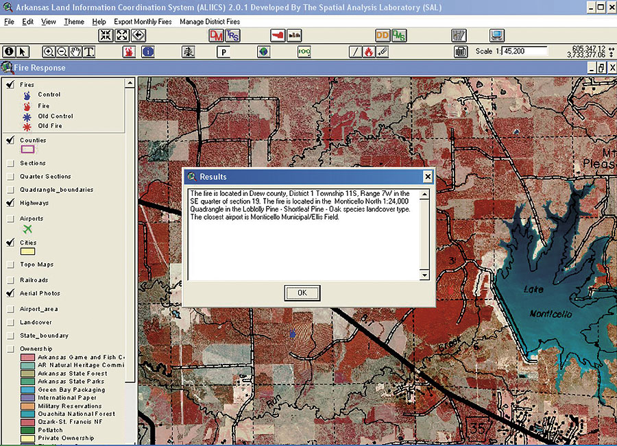
Ten minutes normally isn't a long time, but every second is crucial when trying to stop a wildfire. Until recently, the Arkansas Forestry Commission's forest fire response time was hampered by an outdated process of pinpointing a location. The majority of forest fires in Arkansas are either spotted by aircraft or called in by local citizens. When an aircraft locates a fire, the pilot simply radios the latitude and longitude of the fire to dispatch personnel. In the past, dispatchers would take the latitude and longitude, go to a United States Geological Survey (USGS) quadrant map, and using a T square, determine the township, range, and section of the fire and relay that information to the firefighters. The whole process can take up to 10 minutes.
When average citizens phone in the location of a fire, they usually can't tell the dispatcher the latitude and longitude or section, township, and range. The caller usually describes the location using road names and addresses. Dispatchers would use USGS quad maps to determine the fire's location. With 915 quads in the state offering limited data and maps often more than 50 years old, the process was grueling and inefficient. Recently, the Spatial Analysis Laboratory developed a more efficient forest fire dispatch program using ArcView. ArcView was selected because it doesn't demand excessive processing power, is easily customizable, and meets the needs for dispatching fire response personnel. Moreover, the customized application doesn't require a GIS expert to use it. The Fire Program is composed of 15 data layers, including jurisdiction boundaries, highway maps, airport locations, topography, and one-meter color-infrared aerial photography. When a dispatcher receives a call, the fire can be located three different ways: by latitude and longitude; township, range, and section; or user point. When a pilot radios in the latitude and longitude of a fire, it now takes the dispatcher approximately 10 seconds, as opposed to 10 minutes, to determine not only the township, range, and section of a map but also a wealth of information derived from the 15 different data layers that were not available in the past. After the latitude and longitude are known, the dispatcher simply selects the Add Fire by Latitude-Longitude button and enters the information. The dispatcher is then prompted to enter an incident number and the name of the fire. Now dispatchers have vital information at their fingertips in the form of a small "results" window, including county, district, township, range, section, quad name, land-cover type, and the closest airport. Once the fire is entered in the database and centered in the view, the dispatcher has 15 data layers to display and query. The dispatcher determines which data layers will assist firefighters locating the fire and selects the Create Map button. A map is then created and displayed on the fly, building a dynamic legend and scale bar and highlighting the county in the smaller map of Arkansas. The dispatcher can print the map or export it as a .jpeg, which can be e-mailed or faxed to fire crews. Another method to locate a fire is to simply click on the desired location on the map. This method is used primarily when a fire has been called in by the general public. The dispatcher can easily locate a city or county by selecting the Zoom to County or Zoom to City buttons. After the dispatcher has selected the location of the fire, information such as county name, district, township, range, section, and the closest airport are displayed. The third method to locate a fire is by township, range, and section. It is seldom used because most people who report fires don't know which township, range, or section the fires are in. This method works similar to the first method, except the dispatcher enters the township, range, and section information. Other Bells and WhistlesAfter a fire has been logged, the dispatcher can select the Update Fires to Server button, which updates the master database. The Fire Program compares the local database to that of the master database on the server and adds any new information. By giving all dispatchers an updated copy of the database on their computer, it prevents a fire from being logged twice, preventing redundant records and redundant calls to fire stations. The Return Distance and Azimuth tool allows dispatchers to select an airport and draw a line to a fire. When the mouse button is released, a message box appears with an angle and distance from the airport to the fire, allowing a pilot to more quickly and accurately reach a fire. The dispatchers can also edit the attribute information for a fire by selecting the Edit Fires Database button. With this tool, dispatchers can edit such fields as total acres, crews dispatched, arrival times of those crews, and the time the fire was suppressed. For more information, contact Robert Charles Weih, director, Spatial Analysis Laboratory, University of Arkansas at Monticello (tel.: 870-460-1248, e-mail: weih@uamont.edu). |