Summer 2005
Summer 2005 |
|||||||
|
|
|||||||
Conservation GIS in Slovenia |
|||||
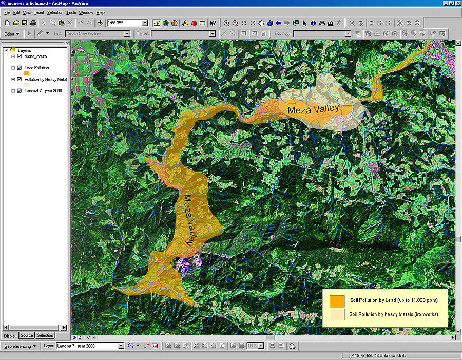
The Society for Conservation GIS (SCGIS) is a nonprofit organization that builds community, provides knowledge, and supports individuals using GIS and science for the conservation of natural resources and cultural heritage. SCGIS Slovenia is a professional, nonprofit, nongovernmental, nonpolitical organization established in 2004 with the mandate to support the professional, scientific, and educational goals of society in the Balkan region in cooperation with the European Union (EU) and U.S. organizations. Slovenia is located in central Europe, measures just over 20,000 square kilometers (roughly the size of New Jersey), and is home to a population of approximately two million people. Its terrain ranges from the Adriatic coast to the Alps. Because of such great diversity in landscape, Slovenia hosts more than 15,000 species, 5,000 varieties of plants, and 5,000 fungi. Conservation agencies have protected 115 wild bird species, and 25 percent of its land is protected under various national and EU directives (e.g., Natura 2000). Even before joining with SCGIS, Slovenia's GIS professionals had been working on various projects of value to the ecology and cultural heritage of Slovenia. SCGIS has a special opportunity to help nonprofit projects, individual researchers, and actions undertaken for the general interest of Slovenia. Monitoring Soil Pollution in the Lower Meza ValleyIn 2000, the first database was completed to monitor soil pollution in the lower Meza Valley. The pioneering results showed a lead concentration considered unbearable for people and animals, in some places above 11,000 parts per million. Through the use of ArcEditor, with the ArcGIS Spatial Analyst and 3D Analyst extensions, the affected regions can be shown on a topographical map. Soil data can be easily updated and new maps easily reproduced, saving time and money with quality assurance. In 2002-2004, a larger research project was initiated to develop a municipal spatial database that would serve as a starting point for future conservation GIS projects. The file-based spatial data is being moved to Geodatabases in ArcGIS 9, since this way of storage enables more functionality with licenses of ArcEditor, especially with the Topology that covers many issues of quality assurance. Finding Lost Cartographic Data
During efforts to acquire old maps dating from 1827 to 1872 from national and surveying archives located in Ljubljana, Ravne, and Klagenfurt (Austria), several maps were missing. Some of these maps were even made by hand. The use of ArcGIS has helped regain or make available much of this important missing geographical and cartographic data. Most of the work was done using on-screen digitizing from scanned maps that were large raster files. The Raster Pyramids in the ArcMap application of ArcEditor helped keep pace with time and performance. The work took nine months, but the maps were preserved in a sustainable way. Free Web Mapping SolutionsAnother project that is under way is obtaining shared technology for conservation GIS projects worldwide. The goal of the project is to offer free Internet mapping solutions on SCGIS Slovenia's server, which will be hosted free at the University of Maribor. SCGIS Slovenia will start hosting student conservation GIS results and applications on the server and evaluating solutions that would enable remote, limited server administration from the authors themselves. Slovenia GIS PortalMost recently, a project called GIS.si was planned and supported by the Academic and Research Network of Slovenia. It will be a GIS portal specialized for Slovenian GIS users and will offer information about GIS technology firsthand in the Slovene language. Education and conservation GIS will be the highest priorities. As a conservation organization, SCGIS Slovenia sees its future in enhancing the community, not only with the latest GIS technology but also by offering individuals adequate educational support. For more information, contact Dejan Gregor, president, Society for Conservation GIS Slovenia (tel.: 386-41-3-1681, e-mail: dejan.gregor@scgis-si.org). Visit SCGIS at www.scgis.org and the Society for Conservation GIS Slovenia at www.scgis-si.org/en. |